Our impact
Explore case studies from researchers working with communities around the world towards positive change.
Posted on 12 January 2016
As rain-swollen rivers wreak havoc across mainland Britain, our environmental scientists head to the beach to predict the effects of rising sea levels on coastal communities
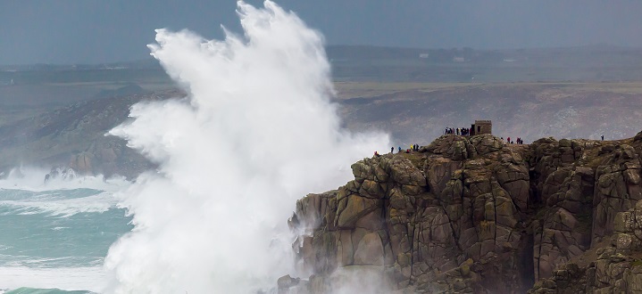
Stormy waters: Our environmental scientists are using the latest computer modelling techniques to predict UK coastal flood risk. Credit: Shutterstock - Ian Woolcock
...we now have the technology to make a much more accurate assessment of the risk to Britain from smaller tsunamis”
Sea levels are on the rise leaving Britain’s coastlines at increased risk of flood damage. Quantifying that risk means examining thousands of years of tidal data, so we can project how sea levels will rise. But what if the data is wrong? What if we are overestimating the risk in some areas and underestimating it in others? We could be spending billions of pounds in the wrong areas and still be liable to flooding.
That’s the danger Dr Jon Hill is aiming to address by bringing the latest numerical modelling techniques to a study involving five British universities.
“Prehistorical sea level is determined by drilling holes to collect sediment cores at different locations around the coast – called Sea Level Index Points,” explains Dr Hill, from our Department of Environment and Geography. “Geologists examine the sediment to determine the sea level in that location at a particular point in time and this allows us to calculate sea level changes over the past few thousand years - and then predict what’s going to happen in the future.”
The problem is that these Sea Level Index Points only show the sea level at maximum tide, not at mean tide. To do that you need to factor in what’s called the tidal range – the difference between high and low tide.
“This has been done,” says Dr Hill, “but generally only using today’s tidal range. The range has actually changed massively over the years and if we don’t take that into account, the data – and our predictions – could be faulty. What we’re proposing is to construct numerical models that simulate the tides around Britain from 20,000 years ago up to the present day – and factor in the historical tidal range. This will allow us to double-check our projections and make sure we are spending our sea defence budgets appropriately.”
Dr Hill's software engineering background makes him especially well qualified to create such models. His cutting-edge techniques have already led to the reassessment of a catastrophic tsunami that hit Britain some 8,000 years ago, and another that surged towards prehistoric Australia 20,000 years ago. In both cases the tsunami was triggered by a submarine landslide, which Dr Hill was able to model with unparalleled accuracy.
“To create this kind of model,” says Dr Hill, “you need to know the topography of the coastline above water, and the equivalent below water, which is called the bathymetry. And, crucially, you need the correct measurements for the timeframe you are studying. We were the first to do that with the Storegga Slide off the coast of Norway, which triggered the tsunami that hit Britain. We created a multi-scale model of the coastline, which allowed us to zoom in on areas of particular interest. Then we programmed in the volume of material involved in the landslide and sent it down the slope in the model to generate the wave.”
What Dr Hill’s reconstruction of the Storegga Slide showed was a tsunami that thundered down the east coast of Scotland and England. If the same wave hit today – something which Hill stresses is not going to happen – Shetland and its oil refineries would be hit by a 12 to 20 metre wave and cities like Aberdeen, Inverness, Dundee and Edinburgh would be engulfed by waves up to 10 metres high.
“The chances of another Storegga are almost zero,” he says, “but we now have the technology to make a much more accurate assessment of the risk to Britain from smaller tsunamis.”
Quantifying the risk of a tsunami means figuring out how often they have occurred in the past. Again this means coring into sediment that the tsunami left behind and using it to work out details such as when the event occurred and how the wave was travelling. Unfortunately the sedimentary evidence is patchy and it currently tells us little about where the wave originated or its size and effect. To make better use of the evidence, Dr Hill plans to use a technique known as inverse modelling – the first time that it has been applied to the study of tsunami deposits.
“This kind of model would take existing tsunami deposit data and move it backwards through time to see what the original landslide looked like. We could then run that same landslide forward to see not just where the tsunami has left behind sedimentary evidence but also the effect the tsunami had in other areas where evidence has not survived. In fact we could even tell geologists where other deposits might be more likely to be lurking. And that new evidence can be used to refine the model still further.”
He plans to start by studying a tsunami that hit Japan in 869 AD. “Japan has the most data – 50 or 60 deposits for that one event alone – so it’s the best place to test the inverse modelling process. Once we have got it working, we can take the existing evidence from anywhere in the world – Japan, Britain and elsewhere – and use it to create a much better base for our risk assessments. That way we can take whatever measures are necessary to keep ourselves safe.”
Dr Hill's work on modelling the effect of tsunamis is funded by NERC
The text of this article is licensed under a Creative Commons Licence. You're free to republish it, as long as you link back to this page and credit us.
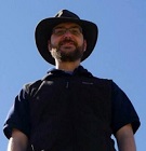
Dr Jon Hill
Research into the application of the latest numerical techniques to a wide range of environmental phenomena, including in the ancient past
Submarine landslides on the Great Barrier Reef shelf edge and upper slope: A mechanism for generating tsunamis on the north-east Australian coast? was published in Science Direct
How does multiscale modelling and inclusion of realistic palaeobathymetry affect numerical simulation of the Storegga Slide tsunami? was published in Science Direct
Watch a computer simulation of the impact of the Storegga Slide
A research project needed to spot trees on historic ordnance survey maps, so colleagues in computer science found a solution.
We’re using gaming technology to ensure prospective teachers are fully prepared for their careers.
A low cost, high-accuracy device, could play a large part in the NHS's 'virtual wards'.
Our monthly research newsletter features a curated mix of news, events, and recent discoveries delivered straight to your inbox.