Our impact
Explore case studies from researchers working with communities around the world towards positive change.
Posted on 15 March 2016
Our environmental scientists are researching natural ways to harness floodwater
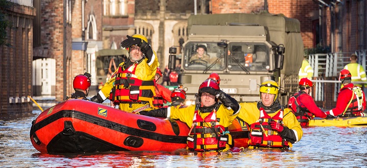
A river runs through it. Police and mountain rescue teams in Kings Staith Road, York at the height of the floods in December 2015
... we have to work in a way that holds back water but, at the same time, maintains the productivity of the farming systems”
The December 2015 floodwater may have receded, but debates still rage about the best way to deal with future torrents. Should we build higher barriers, dredge rivers or provide more flood gates?
These physical barriers will help, says Professor Colin Brown in our Department of Environment and Geography. But, he says, it is also important we take a long hard look at the source of the problem in countryside streams, ditches and natural waterways that act as the feedstock for bigger problems down river.
“There’s no single answer.” says Professor Brown. “But, increasingly, the debate is widening to look at measures that work with nature and the natural landscape and that could be applied as a package with physical barriers further downstream.”
At the centre of that debate, the Water Friendly Farming project, involving research by Professor Brown and his team of environmental experts at York, is testing a range of land and water management options on agricultural land draining into the River Welland in the Leicestershire lowlands.
The £1.3 million project, funded by the Environment Agency, Defra, Syngenta and Anglian Water, is groundbreaking because it is focused on a lowland arable area, rather than upland moors and hillsides where many studies into ‘slowing the flow’ are already under way.
“In upland areas, there is more uncultivated land which can be used for natural flood defences,” says Professor Brown. “The project in Leicestershire is important because it is based on a lowland arable landscape where land is at a premium and where we have to work in a way that holds back water but, at the same time, maintains the productivity of the farming systems.
“This type of arable landscape is common across large areas of the central and eastern UK. It surrounds some of our largest towns and cities so it is important we understand its potential to help in flood alleviation.”
The York team began work on the ground in the Welland catchment in 2012, alongside the Freshwater Habitats Trust and the Game & Wildlife Conservation Trust. With the help of farmers and landowners, our environmental scientists are gathering data which is used to develop computer models demonstrating how the landscape and its water courses react under different weather conditions and land management options.
The models plot the effect of ‘leaky’ log dams introduced in streams to slow the progress of peak flows. They track the impact of new field and woodland ponds, woodland areas and enlarged ditches. Meanders have also been re-introduced to manage flows in some water channels.
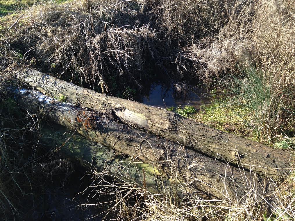
An example of a leaky log dam slowing the flow on a stream draining into the River Welland.
Our researchers are also working with farmers to try different ways of managing the land. This includes moving away from deep ploughing in a bid to improve the soil structure and reduce the amount of soil and sediment run off into local water courses. Strips of uncultivated land around field edges have also been introduced to reduce the amount of soil and nutrients lost to ditches and streams - a system which benefits agriculture and keeps drainage channels clear.
Following the Christmas floods, the team recently gained further funds from the Environment Agency to extend the scope of their water flow prediction models.
“The Agency already has models to predict downstream flows. Combining these with models covering land management options in upper catchments for rivers like the Welland could provide a more accurate overall picture. It could also inform spending decisions to ensure that flood defence budgets are spent on the most cost-effective measures,” says Professor Brown.
The research shows that slowing the flow upstream is likely to require many different options applied over a wide area.
Of all the natural methods tested in the Welland catchment, the one showing most promise involves using land as temporary flood storage – an option already under discussion nationally by politicians and policy makers. These new holding areas, created in part by the leaky log dams which push water out onto surrounding land, have the potential to slow the pace of floodwater as it pours into our downstream communities.
The project team is minimising the amount of agricultural land affected, focusing instead on holding water back within the existing stream banks and directing the water out onto lower grade land such as wooded stream edges or existing uncultivated wetland pockets.
“An upland flood defence scheme at Pickering in North Yorkshire – credited alongside changed soil management practices with protecting the town from the worst of recent floods – holds 120,000 cubic metres of water. Our models show how on intensely farmed lowlands we can hold 80,000 cubic metres of water in one 10km square catchment area using a series of 13 small leaky dams,” says Professor Brown.
“This model is encouraging because it shows how targeted interventions can provide significant amounts of temporary water storage in headwater catchments and make a valuable contribution to flood protection further downstream."
These would not be permanent wetlands because the water would drain after a few days. Farmers may have to be compensated for the work involved in installing and maintaining the systems.
“The reality is that with the volumes of rainwater we have experienced recently, there is no guarantee that any defences will prevent flooding completely,” says Professor Brown. “But our research in the Welland catchment area is helping to inform the debate about the best way to mitigate the worst effects of the weather.
“There’s currently a lot of discussion in the media about dredging rivers, or building more flood defences. Here at York, we are making an important contribution to that debate by providing scientific tools to underpin some very important future decisions.”
The Water Friendly Farming project is funded by the Environment Agency, Defra, Syngenta and Anglian Water
The text of this article is licensed under a Creative Commons Licence. You're free to republish it, as long as you link back to this page and credit us.

Professor Colin Brown
Research interests in the fate and effects of chemicals in the environment including catchment-level monitoring
The Water Friendly Farming project is run by the Freshwater Habitats Trust and the Game and Wildlife Conservation Trust. As well as the team from York, it also involves the University of Sheffield, Oxford Brookes University, Anglian Water, the Welland Rivers Trust and Syngenta
Read the project’s first report Water Friendly Farming – Results and practical implications of the first three year of the programme
The Environment Agency works to create better places for people and wildlife, and support sustainable development
A research project needed to spot trees on historic ordnance survey maps, so colleagues in computer science found a solution.
We’re using gaming technology to ensure prospective teachers are fully prepared for their careers.

A low cost, high-accuracy device, could play a large part in the NHS's 'virtual wards'.
Our monthly research newsletter features a curated mix of news, events, and recent discoveries delivered straight to your inbox.