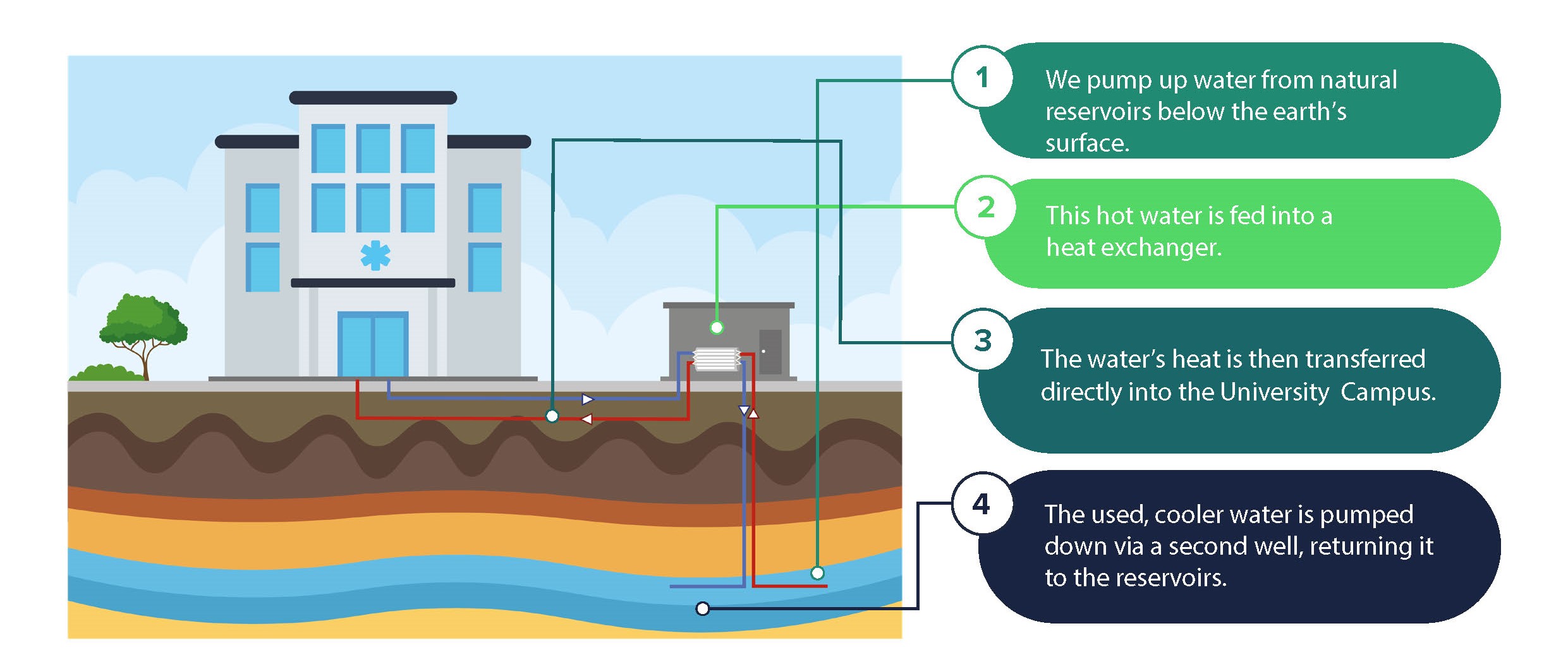
Skip to content Accessibility statement

Seismic survey

As the next step in our Deep Geothermal Energy Project, a seismic survey will take place on Campus East and surrounding areas in late October 2025.

This important early-stage activity, delivered with our specialist contractor Echo Geo, will build a detailed 3D map of the ground and help us understand the size, shape and depth of the geothermal reservoir beneath our feet. Some parts of the reservoir may lie several kilometres below the surface and beneath the borehole on Campus East, so the survey provides a safe, non-intrusive way to collect data and build a clear picture of the project’s potential energy output.

Explore below to find out more about our seismic survey, how it works, how it may affect your area, and opportunities to get involved in this part of the project.

Seismic survey disruption notice

The University, with its specialist partner Echo Geo, will be undertaking a seismic survey on Campus East and surrounding areas between 27 October and 16 November 2025. The survey is a part of the University's Deep Geothermal Project and will help further define the geology beneath our feet.

Please see key details below for more information about the survey, including what it involves, and when and where it will take place.

Seismic Survey Public Notice of Disruption (PDF , 103kb)

Why we're doing a seismic survey

Delivered by our specialist contractors, Echo Geo, our seismic survey is an important early-stage activity which will build a detailed 3D map of the ground, helping us understand the size, shape and depth of the geothermal reservoir beneath our feet.

Watch our video as we explain why we're doing a seismic survey, what's involved, and why it's an important step in our geothermal journey. Hear from Paul Bushnell (Deep Geothermal Project Director, University of York) and Mark Rees (Operations Director, Echo Geo).

What is a seismic survey?

A seismic survey is a safe, non-intrusive method of mapping underground rock layers. It works by sending controlled sound waves into the ground and recording the echoes that bounce back, similar to ultrasound scanning during pregnancy.

The data helps geologists understand the subsurface and assess whether geothermal energy extraction is possible.

Significance for the project

The survey will provide essential data for helping build detailed models of the structures below our feet. By understanding the rock layers and conditions underground, we can determine the potential targets for a geothermal heating source and help us identify areas where we might be able to access naturally heated subsurface water.

This would be a major step forward in reducing fossil fuel use, providing a secure energy source and achieving our Net Zero targets.

The process

To see the structure of underground rock formations, very precise sound waves are sent into the ground across a wide area. Those same waves then travel through the rock and reflect back to the surface where they are picked up by an array of small nodes on the surface.  

The signal is generated using a special truck that vibrates the ground, while the nodes are small wireless devices about the size of a standard pen that are placed in the ground and left recording for the duration of the survey. The data is then processed and analysed by geophysicists to produce a map of the structure below ground in the survey area. From this map we can identify the areas that would most likely be conducive for geothermal energy. 

Step 1: Lay out the nodes

Before recording any data, several seismic teams place 4800 of nodes in a precise pattern, mapped out in advance by surveyors using GPS. The nodes are put out by hand and will not present any danger to the public or wildlife.

Step 2: Vibroseis truck

Once all the nodes have been deployed a Vibroseis truck moves along the survey lines. At set locations, it lowers a large pad and sends vibrations into the ground for around 16 seconds at a time (called a VP). This process is repeated at 25m intervals down each survey line, while the nodes record the returning signals from each VP.

Step 3: Analyse the seismic data

The signals are processed into a geological map which will build a detailed 3D map of the ground and help us understand the size, shape and depth of the geothermal reservoir beneath our feet.

Key details

Use the drop-down menu below to find out about key details of the upcoming seismic survey.

Key dates
  • Mid September: Test Survey -  A one-day test survey takes place on University campus.
  • Mid October: Nodes begin to be laid out across the survey area.
  • Late October: Vibroseis trucks work their way along the survey lines.
  • Mid November: Nodes are collected and data analysis begins.

How it works
  • The survey will run for approximately 30 days of which 10 will be spent on the acquisition, covering approximately 7km of survey profiles each day.
  • At each survey point, a seismic vibrator (mounted on a truck) will lower a plate to the ground every 25m and generate a seismic source. The pad generates a 16-20 second sweep from 8-100 Hz before moving on to the next point.
  • In areas with difficult terrain, this same system can be mounted on a small tractor or all-terrain vehicle.
  • The sound waves are recorded by sensitive seismic sensors (nodes), which will be temporarily placed in the ground. All survey work will be carefully planned to avoid obstacles and minimise disruption.
  • The data from these nodes is then downloaded and analysed to produce a 3D map of the geological structure beneath the survey area.
What will I notice?

The seismic trucks driving past will be the equivalent to a large tractor or piece of large machinery. The truck will follow survey lines, creating a mild localised vibration. This may be felt going from low frequency to high briefly at the immediate location of survey points. These are low impact and closely monitored.

You may see small sensors (“nodes”) along roads and tracks. These are safe and should not be disturbed, and will be collected after the survey.

Where the work will take place

One or two trucks will work their way along the survey lines. Most of the work will take place off-road on private land, though some short sections of activity will take place across the University’s campus and the surrounding areas near Osbaldwick, Murton Park and Derwenthorpe.

Any temporary disruptions, scheduled late October/early November, will be brief and at off-peak times, although some short-term traffic delays may be experienced. Visit the map below for full details of the areas.

Survey area

The map below shows the areas where the seismic survey will take place, along with key dates associated with each road, scheduled between late-October and mid-November. These dates will be updated regularly so please keep checking here for the updates.

Dates of survey trucks on roads

5 November: Hull Road, Stamford Bridge Road, York Road, Elvington Lane, Murton Lane

6 November: Murton Way, Osbaldwick Link Road, Stockton Lane, Holtby Lane, Bad Bargain Lane, Moor Lane

7 November: Hopgrove Lane S, Malton Road, Jockey Lane, New Lane

8 November: UoY Campus East, Field Lane, Church Lane, Innovation Way, Low Lane, Common Lane, Long Lane, Langwith Stray

10 November: Malton Road, Stockton Lane, Hempland Avenue, Whitby Ave, Bramley Garth

11 November: Bad Bargain Lane, Osbaldwick Lane, Millfield Lane

Opportunities to get involved

If you live in the survey area, you could help us by hosting a small seismic sensor in your garden. It’s simple, safe and will help us collect vital data. If you’d like to take part, please complete the short Google Form.

Paid opportunity for students

We’re looking for a team of students to support the survey work, helping with tasks like placing and collecting sensors and leafleting in the survey area (deadline now passed - look out for future opportunities soon).

Frequently Asked Questions (FAQs)

Will I feel anything?

The survey is designed to be low impact and will only be felt in the immediate location of the seismic lines, which you can find on the map above. In residential areas, our monitoring teams will be actively checking vibration levels.

Will I hear anything?

Although fitted with engine sound proofing, the seismic truck engines may be heard when in close proximity. A small distant thud may be heard from time to time when a weight from the truck drops to the ground.

Will there be any traffic delays?

Most of the work is taking place off-road on private land, however, there are some survey lines around the University campus and to the north of the University near Osbaldwick, Murton Park and Derwenthorpe. The work will be during daytime hours and for short periods only.

There may be some short-term traffic delays, and some evening and night work may be required on farm tracks and on some roads, such as the A64.

What if I see a sensor?

Small sensors (called “nodes”) may be occasionally visible. These pose no danger to the public or animals, and should be left alone as they are recording sensitive signals. They will be collected after the survey is completed.

Will my area be affected?

The majority of Campus West will experience no effect from the survey. If you are on Campus East, in the science park or around 22 acres you may see the nodes in the ground or see the trucks when they come to do their work. 

There may be some traffic management in place in areas around the University for very short periods when the trucks are working on a highway.

You can find out whether your area will be affected via our map (see above). This map indicates the routes / roads affected on which dates.

I’m a staff or student based on Campus East. How will this affect me?

The majority of work will be done during working hours between dawn and dusk on Campus East. There is only one truck operating during the data collection and although it will work along roads on Campus East it will be during daytime and for short periods only. 

There will also be some evening and night work required on some roads such as the A64, and other other units working on farm tracks while the units in the urban areas are detouring.

How will this help the geothermal project?

This important early-stage activity will build a detailed 3D map of the ground and help us understand the size, shape and depth of the geothermal reservoir beneath our feet.

We are very grateful to our staff, students and the local community for their support and apologise in advance of any inconvenience.

Who should I contact?

Echo Geo are delivering the works on behalf of the University. For any questions or queries about the survey works, you can email, WhatsApp or call them:

Email address: york_info@echo-geo.net

Phone number: 07384 297 761

Sign up to our mailing list

The geothermal energy project is a growing initiative and we’re keen to connect with individuals and groups who are interested in being part of the journey. Whether you’re a member of staff, a student, or part of the local community, there will be a range of ways to get involved as the project develops.

Sign up to our mailing list below to receive project updates and find out about potential opportunities to get involved.

Contact us

Geothermal Project enquiries