Posted on 2 October 2025
The next step in our Deep Geothermal Project journey is a seismic (geophysical) survey, delivered with our specialist contractor, Echo Geo. This important early-stage work will help us map out the geothermal energy heat source.

As part of the University's Deep Geothermal Project, a seismic survey will take place on Campus East and surrounding areas from late-October until mid-November. Delivered by our specialist contractors, Echo Geo, this important early-stage activity will build a detailed 3D map of the ground and help us understand the size, shape and depth of the geothermal reservoir beneath our feet.
Read below to find out more about our seismic survey, how it works, how it may affect your area, and opportunities to get involved in this part of the project.
What is a seismic survey?
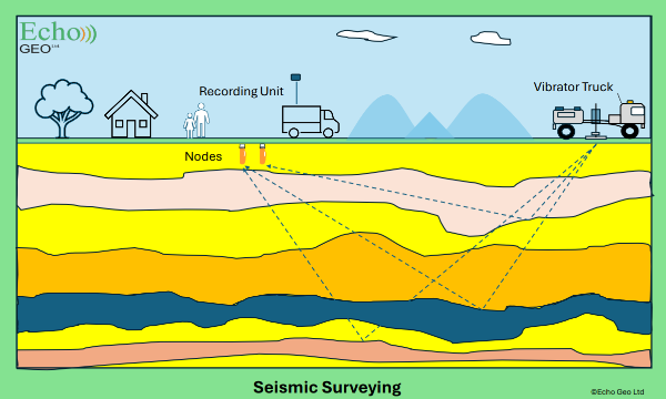
A seismic survey is a safe, non-intrusive method of mapping underground rock layers. It works by sending controlled sound waves into the ground and recording the echoes that bounce back, similar to ultrasound scanning during pregnancy.
The data helps geologists understand the subsurface and assess whether geothermal energy extraction is possible.
Why is it an important part of our project?
The survey will provide essential data for helping build detailed models of the structures below our feet. By understanding the rock layers and conditions underground, we can determine the potential targets for a geothermal heating source and help us identify areas where we might be able to access naturally heated subsurface water.
This would be a major step forward in reducing fossil fuel use, providing a secure energy source and achieving our Net Zero targets.
What’s involved in a seismic survey?
To see the structure of underground rock formations, very precise sound waves are sent into the ground across a wide area. Those same waves then travel through the rock and reflect back to the surface where they are picked up by an array of small nodes on the surface.
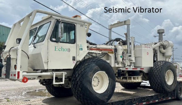
The signal is generated using a special truck that vibrates the ground, while the nodes are small wireless devices about the size of a standard pen that are placed in the ground and left recording for the duration of the survey. The data is then processed and analysed by geophysicists to produce a map of the structure below ground in the survey area. From this map we can identify the areas that would most likely be conducive for geothermal energy.
Where the work will take place
One or two trucks will work their way along the survey lines. Most of the work will take place off-road on private land, though some short sections of activity will take place across the University’s campus and the surrounding area near Osbaldwick, Murton Park and Derwenthorpe. Any temporary disruptions, scheduled late October/early November, will be brief and at off-peak times, although some short-term traffic delays may be experienced. Visit our interactive map for full details of the areas.
Get involved: host a sensor in your garden
If you live in the survey area, you could help us by hosting a small seismic sensor in your garden. It’s simple, safe and will help us collect vital data. Apply by completing our Google Form.
Have questions? Come along to our Open Days
As part of York Environment Festival and World Geothermal Day 2025, we’ll be hosting a series of public events that dive into the world of geothermal energy, and provide an opportunity to ask questions about the seismic survey and geothermal project as a whole.
- Wednesday 15 October - Exploring Geothermal Energy drop-in: Tang Hall Explore
- Thursday 16 October - Exploring Geothermal Energy drop-in: York Explore Library
- Friday 17 October - Seismic Survey Open Day: Ron Cooke Hub, Campus East
- Friday 17 October - York's Geothermal Exploration: Evening Public Talk