The Archaeology of a Protected Area
Posted on Wednesday 10 May 2023
There is overwhelming evidence that this is one of best options available to stem loss of global biodiversity.
But how did existing protected areas become worth protecting in the first place? And what does that mean for expanding protected areas now to meet 30 by 30 targets? In landscapes dominated by human activities (which arguably includes most of the terrestrial surface of the globe), these are questions that can be addressed through Archaeology.
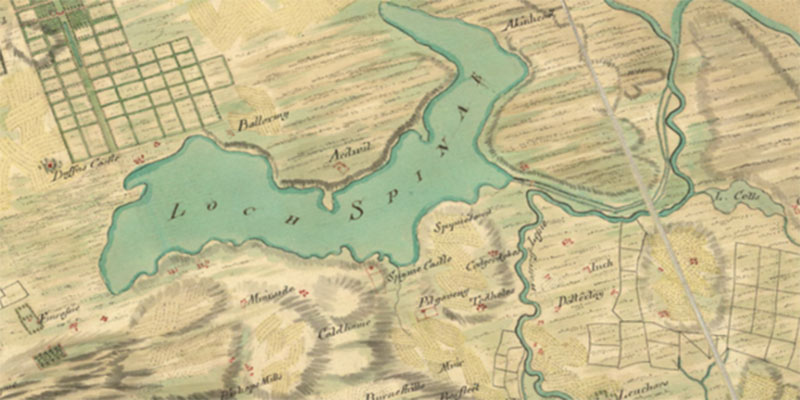
This is the scope of an ongoing project I am leading, funded by a British Academy Small Grant and working with the RSPB. The project is examining a Ramsar designated wetland, Loch Spynie, located near the Moray Firth Coast in Scotland.
Loch Spynie has a surprising, although not unparalleled, landscape history of the past 12,000 years. As the last Ice Age ended and glaciers melted, this part of the world saw sea-levels fall as the weight of the ice was lifted and the earth’s crust rebounded upwards.
What is now Loch Spynie went from being mostly submerged to dry land, to submerged again, but now as a lagoon or estuary of the River Lossie. Through time the lagoon became smaller thanks to the ongoing process of lifting following the melting of the glaciers.
Over this period, the climate and ecologies changed and throughout people lived in and exploited the rich resources of this dynamic coastal wetland landscape. Evidence for this is preserved across the region and includes exceptional archaeological sites and finds from all periods.
Some highlights include: a large funerary monument dating to the Neolithic, jet artefacts dating to the Bronze Age whose raw material originated in Yorkshire, sea caves where human remains were interred, a large and well defended fort of the early medieval Pictish Kingdom, and several large medieval castles all of which were built and lived in around the shores of the Loch Spynie lagoon.

Looking east across the former lagoon from the 11th century Duffus Castle which was built on the shoreline. From this point in the western half of the basin, the lagoon stretched around 7 km to the east where it met the wider Moray Firth. Photograph Michael Stratigos
This rich archaeological record can shed further light on how this landscape developed. In March with help from local volunteers, we undertook fieldwalking which aimed to assess whether it would be possible to see the shadow of the former lagoon in surface archaeological finds.
The hypothesis here being that sites and artefacts through time should respect the shoreline of the changing lagoon. This might throw new light on where and what type of landscape features were present around the former the lagoon.
Over several days, finds turned up from all periods of human history in this region from the Mesolithic to the recent past, although in somewhat less quantity than hoped.
The hypothesis remains intact though, with the few earlier prehistoric finds especially respecting the more expansive lagoon’s shorelines, while later material, in particular ceramic tile drain fragments being found lower down in locations which would have been underwater or intertidal mudflat until around 500 years ago.
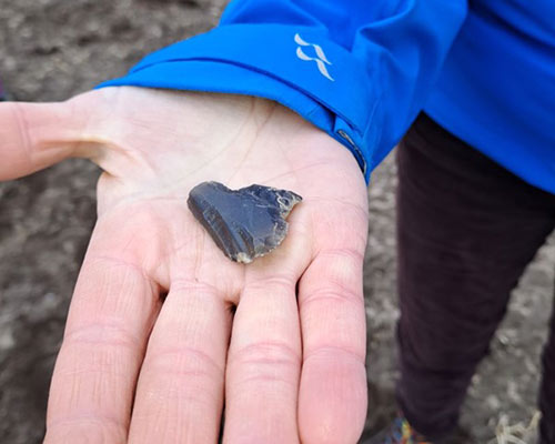
A lithic, probably of non-local geology, collected from just above where the Neolithic shoreline of the lagoon would have been located. Photograph Michael Stratigos.
In addition to fieldwalking, the project has undertaken a programme of targeted archaeological excavation of a shell midden located on the shore former lagoon. The shell midden was substantially quarried in the 19th century for agricultural purposes, but in situ deposits remained across the site.
These deposits were dominated by Periwinkle (Littorina sp.) and oyster (Ostrea edule) with lesser amounts of cockle (Cerastoderma sp.) and mussel (Mytilus edulis) along with a few other species.
No diagnostic artefacts were found during the excavation, however, charred cereal grains were recovered, so we are likely looking at a shell midden dating to the Neolithic or later.
Radiocarbon dating will refine the overall site chronology. The shell midden excavation provides a window into the conditions of the former lagoon. Based on the species present in the midden and their relative abundance, it is clear that the former lagoon, before it became a freshwater loch, had a broad sandy/muddy bottom. Further analysis will provide greater detail on the marine and likely brackish conditions of the former lagoon.
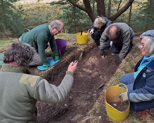
Local volunteers excavating through the shell midden which sits on a beach ridge with the former lagoon just beyond. Photograph Michael Stratigos.
Sometime between AD 1400–1600 the lagoon became a freshwater loch due to sand dune and coastal progradation across the outlet which had been established between two sets of gravel beach ridges. Beginning in the 18th century, efforts began to drain the now freshwater loch and surrounding bog and other wetland which extended well over 1000 ha.
This culminated in implementing a design by Thomas Telford that created a large canal separating the outflow of the main basin and the River Lossie. The canal along with an extensive network of other canals and ditches are still used to maintain artificially low water levels supporting arable agriculture.
During this time, several legal cases and estate sales resulted in a substantial documentary record which add further detail to understanding the processes of landscape change over the past 300 years resulting in the present condition of Loch Spynie.
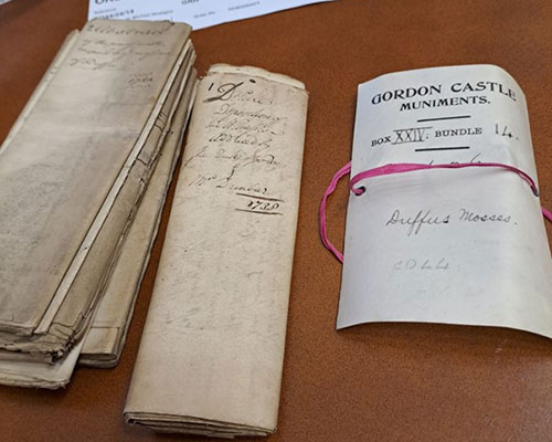
Photograph Michael Stratigos with permission from the National Records of Scotland and the Goodwood Collection.
This document from 1738 records depositions from local inhabitants concerning the bogs, known as mosses, and what rights they had there and to whom they belonged. These were contested areas as important sources of fuel and other land rights.
They also include details about the environmental condition of the bogs variously describing them according to their use at the time. Today these locations around Loch Spynie are mostly small patches of conifer plantation.
All that remains of the formerly extensive lagoon and surrounding wetland environments is a small loch that was purposefully retained in the 19th century to provide a location for hunting waterfowl.
This small remnant wetland was then designated as a Site of Special Scientific Interest (SSSI) in the 1980s followed by Ramsar designation in the 1990s. At one time in the late 1980s, this small remnant loch supported overwintering for around 9% of the Iceland/UK/Ireland population of greylag geese (Anser anser) as well as containing other rare and important freshwater habitat and species.
Loch Spynie therefore represents an excellent example of the tensions inherent in biological protected areas for regions which are composed mostly or entirely of cultural landscapes.
30 by 30 ostensibly aims to protect nature, but in the case of Loch Spynie, what is ‘natural’ here? The loch is part of a drained and designed landscape, intended to attract waterfowl (where it clearly succeeded).
But it couldn’t be said to be natural in the sense of being devoid of human modification. Not only has it been modified, it only exists because of human activity.
On the other hand, it clearly is an excellent place for wetland species in this region which has otherwise seen systematic removal of small wetland habitats over the past 300 years.
Should we be at all concerned that it is a deeply modified habitat? Perhaps not, and archaeology and documentary research can shed light on this for conservation biologists in two ways.
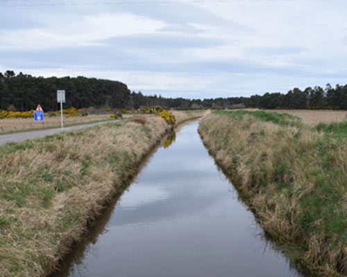
In addition to the main Spynie Canal, this ditch, the Innes Canal drains the eastern half of the former Loch Spynie lagoon and passes through what would have been the outlet to Moray Firth. For most of the past 6000 years, the tidal inlet would have flowed roughly between the two stands of conifer plantation in the middle and background of this photograph. Photograph Michael Stratigos.
The first is to provide an archive of past conditions. That is to say, we can use data from the archaeological and documentary records to say with confidence things used to be a certain way.
This can inform what aspects of that environment we want to see maintained or reinstated. It is this approach archaeology has most often taken in pursuit of delivering biological conservation and it is very useful and important.
At Loch Spynie, we now have additional evidence for what this large former lagoon looked like and what species lived there through time. Pulling together all the documentary evidence has also revealed more information on how the hydrology of the freshwater loch and surrounding wetland has changed over the past 300 years. Any of the information contained within this ‘archive’ might be useful in making management decisions regarding the Loch Spynie RSPB reserve.
However, there is another facet to how knowledge of the past can inform biological conservation. This uses archaeology to understand the processes of landscape change. This provides context, critique and framing around why and how protected areas have come to be and what that means for the present and future.
In the case of Loch Spynie, it is clear that this landscape has constantly been in flux (at least at the chronological resolution at which can look into the past). However, over the past 300 years and specifically through the development of land ownership and management in this landscape, the once dynamic coastal wetland environment has become fossilised for the past 100–150 years.
In the face of climate change, this blip of mostly unchanging wetland habitat form and composition, is highly likely to return to a more dynamic one unless ever greater intensive management is put in place.
Furthermore, understanding the processes of landscape change highlight that human impacts have been constant throughout the existence of the habitats and species now valued and protected at the Loch Spynie RSPB reserve. And that this has not necessarily always been negative for biodiversity or wider ecosystem services.
The above results, themes and more will now form the basis of the second phase of this project. Working with RSPB ecologists and reserve managers, we will explore tangible ways we can take archaeological perspectives on the past and its ever-changing biodiversity, and bring them to bear on protecting biodiversity for the future.
The tangible and intangible cultural heritage of millions of people are likely to be impacted by meeting 30 by 30 targets. In order to ensure the best possible outcomes for nature and people, studies like this one are going to be required to demonstrate the deep time and recent past connections between humans and their environment; which are responsible for the valued biodiversity we are set to protect with expanded protected areas.
Thank you to the local volunteers who made so much of this work possible and to the staff at the National Records of Scotland who facilitated access to the documentary records consulted.
Thank you also to Pitgavney for permission to conduct the fieldwork and colleagues at the RSPB for their engagement with this project.
Funding for the project has been provided by the British Academy through a Small Grant and the author also has support from the Leverhulme Centre for Anthropocene Biodiversity and the University of York Department of Archaeology.