Department of Archaeology
HEEAL: Historical Ecologies of East African Landscapes
2010
The historical ecology of the Pare Mountains, Tanzania. 3rd field season, January to March 2010.
When the first European explorers reached the Pare Mountains in northeastern Tanzania during the late 19th century they did so by travelling along what was, by then, a well established caravan route that supplied the east African coastal ports with slaves and ivory from the interior. These travellers described Pare as a largely treeless landscape characterised by the cultivation of bananas and grain crops, and report that agriculture in the highlands was sufficiently intensive to include extensive networks of irrigation channels and large areas of dry-stone terracing. They note too that the area was famed at this time for the quality of the iron produced locally, and comment that forests were restricted to a few mountain peaks and to numerous small woods within the cultivation area. This suggested to these travellers that much of Pare was deforested for farming and/or fuelwood extraction, and has suggested to more recent commentators that this process of deforestation led to the soil erosion and loss of river flows that remain a problem today. However, the continued use of irrigation and agricultural terracing, the high biodiversity of the area’s forests, and the protection afforded some of these woodlands as sacred groves, has also suggested that local practices may be economically and environmentally sustainable, and indeed various NGO projects established in the area since the 1990s have aimed to promote the use of ‘traditional’ land-management techniques.
Building on recent palaeoenvironmental research carried out by the York Institute for Tropical Ecosystem Dynamics (KITE), two HEEAL sub-subjects are investigating the veracity of these historical narratives. The most recent phase of this fieldwork focussed on the possible links between farming, iron working, forest histories and soil erosion. Soil catenas were established by Matthias Heckmann in areas associated with historic iron working sites, while these archaeological sites were themselves surveyed and excavated by Daryl Stump. Early results suggest that in highland areas deep deposits of colluvial material predate the establishment of iron smithing sites, and that the onset of soil erosion in these upland locations is associated with clearance of forests for agriculture c. 1000 years ago. Iron working sites in the lowlands have yet to be dated, but the location of in-situ iron smelting furnaces within the erosion sequence will act as important stratigraphic markers to help define the nature, date and extent of erosion in these locales. It would nevertheless appear that the most severe phases of erosion date to the modern period, as indeed is evidenced by the rapid and ongoing incision of erosion gullies in and around the town of Mwanga.
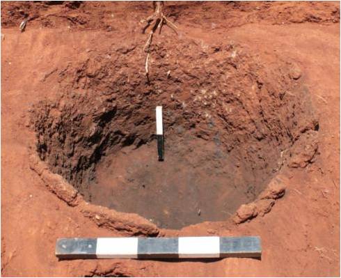
Iron smelting furnace sealed by colluvial deposit, Mwanga, North Pare.
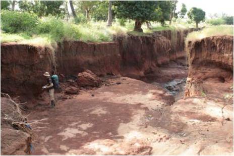
Sequence of deep colluvial deposits revealed by recent gully erosion, Mwanga, North Pare.
2009
Further fieldwork was undertaken as part of post-doctoral project A
between early February and early April 2009, and included work in both
North and South Pare as well as a week spent at Engaruka, Arusha
District. The work at Engaruka was undertaken in collaboration with
Lars-Ove Westerberg (a member of the University of Stockholm’s PLATINA
research group [and Vesa Laulumaa (University of Helsinki, Cultural
Ecology of the East African Savanna Environment project with the
intention of collecting 10 samples for preliminary optically stimulated
luminescence (OSL) dating of the abandoned field system and associated
irrigation features. This brief visit follows Stump’s previous work at
this Late Iron Age site (summarised here) and was carried out in advance
of a large excavation and survey project currently planned for
July-August 2010.
Following on from surveys and excavations undertaken in 2008
(outlined below), work in Pare continued the mapping of structures
thought to be associated with the intensification of agriculture in
precolonial Pare, but was also expanded to include surveys of sacred
groves and iron working sites; the later conducted partly in
collaboration with Edwinus Lyaya (then of the University of Dar es
Salaam and now conducting a PhD at the Institute of Archaeology, UCL).
This expansion of the methodology reflects two related hypotheses cited
locally and within the historical and ecological literature; one linking
deforestation to large-scale fuelwood extraction for iron production
whilst another sees forest clearance as being related to agricultural
intensification.
Irrigation structures and cultivation terraces were investigated in
the Usangi, Ugweno and Lembeni areas of North Pare and in the Vudee area
of South Pare. Once features of this sort were located, interviews
were conducted with local farmers as to the age and function of these
structures and samples taken for radiocarbon and OSL dating. These
samples are to be processed by Mattias Heckmann under the supervision of
Mark Bateman at the University of Sheffield, and will be employed to
help target further fieldwork in these areas. In addition, trial
excavations were undertaken within two groups of agricultural terraces
in Lembeni, North Pare, and Vudee, South Pare. Both groups are believed
by local residents to date to the 19th century or earlier, and indeed
the group in Vudee had previously been recorded by Fosbrooke in the
1940s when he was told that they predated the arrival of Pare
communities. Despite being located less than 40km apart, excavations
within these two sets of terraces showed them to have very different
construction techniques, those in Vudee having been built by cutting
into underlying deposits on their up-slope side, whilst those in Lebeni
consist of a series of free-standing dry-stone walls. This may reflect
differences in function, but may also prove to be evidence of distinct
building traditions in these two areas.
Pending results from OSL samples these terraces and irrigation
features remain undated, but on the basis of information received
locally and the published accounts of 19th-century European travellers
it is anticipated that many of these samples will produce dates relating
to the 19th century or earlier. Baumann (1891), for example, provides
an accurate description of the construction and operation of ndiva
irrigation reservoirs, describes “extensive districts” of terracing, and
also refers to the prevalence of small iron working sites in the Vudee
area of South Pare and along the Chunguli River that formerly marked the
boundary between Ugweno and Usangi in North Pare. Indeed, historical
information of this sort has been cited in support of the two
deforestation hypotheses mentioned above. Surveys of iron working sites
conducted during this fieldwork season therefore paid particular
attention to the areas mentioned in the the early European sources, with
preliminary observations of iron slag indicating that Baumann, Kirsten
and others actually witnessed iron smithing (the process of working
smelted iron into usable tools or tradable ingots) rather than smelting
(the process of turning raw iron ore into iron), and would suggest that
smelting was primarily undertaken in the lower foothills. It should be
noted too, however, that several iron smelting sites in these lowland
areas identified by Ordner in his 1971 Azania article would seem on the
basis of associated artefacts to be either Early Iron Age (EIA) in date
or to have been long-lived or periodically occupied sites with EIA
antecedence; a conclusion that receives some support from observations
made during the current survey. Charcoal samples retrieved from these
sites will be submitted for dating, though where sample size allows it
is hoped that these can also be used for species identification. If so
this information can be compared with palaeoenvironmental data and to
ethnographic evidence indicating the tree species preferred for charcoal
production by ironworkers.
Ashley Coutu was in Kenya and Tanzania from February to April 2009,
where she took elephant samples in the National Museums Kenya (osteology
and archaeology departments) and House of Wonders in Zanzibar and
negotiated access to samples in the ivory rooms at the Wildlife Division
in Dar es Salaam, Tanzania. She also conducted archival work in
Nairobi, Arusha, Dar es Salaam, and Stone Town for historical documents
relating to the ivory trade including Zanzibar merchant records and game
division policies related to elephant hunting.
Pauline von Hellermann was in Tanzania from 9th May to 23rd June 2009, where she completed her archival research in the Tanzanian National Archives in Dar es Salaam and her ethnographic research in the Pare Mountains. Here, her main base was again in Chome, where she conducted a detailed surveys of trees on farms, sacred groves and community forests, using GPS to map these and compiling a data base of the different trees species she encountered and their local uses and meanings (tree names so far mostly in Kipare or Kiswahili). She also revisited Vudee, Mbaga and Gonja where she gathered detailed information relating to the repeat photography project she started last year.
Thomas Biginagwa returned to Tanzania for a second round of field work in the areas of the lower Pangani from July to October 2009 where he excavated and conducted oral interviews in the villages of Ngombezi, Kwa Sigi and Old Korogwe. His test excavations at the islands of Kwa Sigi and Old Korogwe, which aimed at comparing data from other island sites, yielded bunches of data, notably faunal remains, pottery, imported glass and plastic beads, smoking pipes, cowrie shells, metal objects, burnt seeds (maize), German coins and daub. These materials were similar to those obtained last year from the major site of Ngombezi. The findings imply that both Zigua islands along the Pangani River in the area of Korogwe participated in the caravan trade, and most likely from the 17th century until it stopped. Imported goods such as beads, guns and metal objects obtained from both islands attest to the involvement of the island communities in the caravan trade.
2008
Daryl Stump, Matthias Heckmann and Thomas Biginagwa left in April and
spent two months surveying and excavating in the North and South Pare
Mountains and in the Pangani valley.
Building on an earlier survey of 109 reservoirs or dams in the
Usangi area undertaken by Sheridan in 1997, Stump recorded 31 such
structures, 17 of which were previously unrecorded. A further eight
ndiva were noted to have been abandoned, re-used or heavily modified
since the time of Sheridan’s study. The locations of these features
were plotted, photographs taken, notes made regarding their topographic
and ecological setting, and measurements of their dimensions recorded.
In addition, interviews were carried out regarding local understandings
of the history of these irrigation features in particular, and of the
history of the landscape more generally. This simple survey suggests
that it should be possible to plot the relationships between various
irrigation features (especially where ndiva are solely fed by furrows
originating from earlier artificial reservoirs) and to relate this
development to changes in ecological conditions understood though
geo-archaeological and palaeo-environmental analyses.
As effective sediment traps it was anticipated that the ndiva
themselves would be good sources of this palaeo-environmental data in
the form of macro- and microscopic plant remains, with the waterlogged
conditions within these structures aiding archaeological preservation.
From the results of the excavated example, however, it is apparent that
regular maintenance and cleaning of these structures acts to limit their
potential in this regard, though the identification of long-abandoned
examples would clearly avoid this problem. A section excavated across
Ndiva Ilama in Chomvu, Usangi, recorded up to 0.74m of organic-rich
sediments, all of which had been deposited since the last time the
feature had been cleaned in 1998. Nevertheless, substantial undisturbed
deposits survived within the artificial bank stratigraphically below
these modern layers. Pottery sherds and a single carbon sample
recovered from within a section excavated across the bank of Ndiva Ilame
await analysis, but the presence of dateable materials from secure
contexts within these structures demonstrates the potential for
archaeological enquiries to add precise details to our understanding of
the history of agriculture in this area. Moreover, by revealing the
existence of a substantial dry-stone foundation to this structure that
was unknown to local informants it is clear that archaeological
investigations can provide structural details and thereby contribute to
discussions regarding the labour requirements of intensive agriculture
in Pare.
Heckmann's fieldwork project focused on a series of basins in the
Usangi area of North Pare, Kilimanjaro Region. These areas were chosen
because it was anticipated that sediments would be well preserved due to
the limited outflow via small, seasonal streams. Soils eroding from
the steep hillsides would therefore be retained within the basins and
are likely to record erosion and sedimentation histories. To confirm
this, the project investigated a slope catena on the southern side of a
basin at Lomwe, and combined this with coring of swamp deposits in the
bottom of the basin. Investigation of the basin bottom sediments of the
Lomwe valley revealed a peat layer buried by c2m of loamy sediments.
Macroscopic plant remains are well preserved. A preliminary slope
catena comprising 6 profile pits shows deep colluvial deposits of up to
5.5m in depth. Macroscopic charcoal was abundant in the top 3m
indicating frequent burning of possible anthropogenic origin during the
deposition period. Buried topsoil immediately above the weathered
bedrock was found in three of the six colluvial soil pits indicating
stable conditions before the deposition of the deep colluvial sediment
layer.
In addition to this work within the highland basins, a series of
surveys were also undertaken at the foot of the Pare Mountains in
locations where material derived from upland soils are likely to have
accumulated. This involved the inspection of a series of erosion
gullies and incised river channels on the western and eastern sides of
North and South Pare. Recent gully formation can be observed on the
foot slopes, particularly around Mwanga, Kilimanjaro District. These
gully sections expose several palaeosols reporting land surface
stability between phases of erosion and sedimentation.
A further aim of this research trip was to identify sites for Thomas
Biginagwa to excavate for his research on the 18th and 19th century
caravan trade. Initial fieldwork aimed simply to relocate the sites of
Ngombezi and Kwa Fungo previously identified by Lane, and to assess
their state of preservation. In addition the islands of Kwa Sigi and
Hale were also visited because islands within the Pangani are known from
19th-century documentary and oral accounts to have been preferred
locations for markets and related settlements at this time. Of these
four areas, the site of Ngombezi near Korogwe was considered to be the
most promising location for further work. Numerous pottery sherds and
faunal remains were noted across the area, with particularly dense
concentrations revealed in recently tilled topsoil on one side of a
large earth bank. The fine and ashy composition of the soil within this
bank and the density of archaeological material suggested the
possibility that much of the mound was artificial, having resulted from
the accumulation of archaeological materials over an extended period.
A summary of Stump's, Heckmann's and Biginagwa's fieldwork produced
for the Tanzania Commission on Science and Technology (COSTECH) can be
accessed here.
Ashley Coutu joined the other team members in May and helped with
excavations in Kisiwani. Her main aim on this trip was to secure the
elephant ivory/bone/teeth samples she needs for isotope analysis on
modern Kenyan/Tanzanian elephants, in order to create baseline data for
her historic elephant isotope values. She formed links with Ogeto Mwebi,
Head of the Osteology department of National Museums Kenya, and will be
there to sample from the osteology collection in February 2009. She
also did archival work at the IUCN Elephant Specialist Group in
Nairobi. In Tanzania, she procured her TAWIRI permit to do research in
Tanzania for the next year, and she will be working in conjunction with
them, the Wildlife Division, as well as TANAPA in taking Tanzanian
samples from January-March 2009.
Pauline von Hellermann was in Tanzania from 3rd June to 3rd September. She conducted archival research in the National Archives in Dar es Salaam and ethnographic research in Chome in the South Pare Mountains. Using photos taken by Wilhelm Guth and others working for the Leipzig Mission in the South Pare Mountains, she did repeat photography to record landscape change, and for this purpose visited Mbaga, Vudee and Gonja as well as Chome.
Between August and October, Biginagwa conducted a field school with archaeology students from the University of Dar es Salaam at Ngombezi site, near Korogwe. A 14m by 2m trench was excavated across the site under Biginagwa's direction. This excavation revealed more than 2m of well-stratified deposits including the remains of at least one post-built structure and several possible earth floors. The recovery of large quantities of house daub and animal bones further attest to a settlement at this location. Other finds include multiple glass and shell beads and considerable quantities of pottery, the types and forms of which indicate continued or recurrent occupation of the site from at least the Middle Iron Age onwards. The artefactual assemblage is currently being studied by Biginagwa at USDM, whilst the faunal material will be examined under the supervision of Professor Terry O’Connor at the Archaeology Department, University of York.
Related projects
- KITE York Institute for Tropical Ecosystem Dynamic
- CELP York Centre for Ecology, Law and Policy
- SEALINKS Bridging Continents Across the Sea: Multi-disciplinary perspectives on the prehistoric emergence of long-distance maritime contacts
- PLATINA - People Land and Time in Africa
Key documents