Department of Archaeology
The Southern Red Sea Project
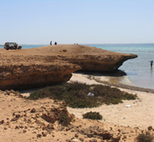
Description
This project took place between 2007-2009, and was a joint Saudi-UK project, led by Geoff Bailey and Abdullah Alsahrekh (King Saud University), as a continuation of the Africa-Arabia Connections project.
Research Context
Considerable interest has focussed in recent years on the 'southern dispersal route' for Pleistocene human dispersal between Africa and Asia, i.e. across the southern end of the Red Sea and directly into the Arabian Peninsula and around the coastline of the Indian Ocean into southern Asia, especially for anatomically modern humans within the past 150,000 years.
However, despite numerous surface finds of stone tools in the Arabian Peninsula and much speculation there is a:
- Dearth of well-dated field data in the critical region of southern Arabia
- Uncertainty about the impact of sea level change on the Bab al Mandab crossing and its implications for sea crossings
- Unresolved questions about the time depth of human exploitation of marine resources
- Growing realisation that most of the relevant evidence is on now-submerged coastlines that require the development of underwater techniques of archaeological and palaeoenvironmental survey
This project built on the results of the Africa-Arabia Connections project and was designed to continue field explorations and field observations in the Farasan Islands and to develop the framework of understanding and collaborative arrangements to sustain long-term fieldwork in the region.
Funding
- British Academy
- National Geographic Society
Sponsors
- Deputy Ministry of Education, Saudi Arabia
- Commission for Tourism and Antiquities, Saudi Arabia
Objectives
Project Aims
- To conduct new investigations of the onshore coastal record on the Farasan Islands of Saudi Arabia
- To continue exploratory investigation of the submerged landscape in the vicinity of the Farasan Islands
Project Objectives
- To complete the survey of coastal sites on the Farasan Islands
- To undertake test excavations of selected shell middens, in order to refine understanding of the variability of the on-shore archaeological record, in particular the chronological, geoarchaeological, palaeoeconomic and palaeoenvironmental characteristics of the shell mound sequence
- To use remote sensing techniques to map more widely the offshore topography in the light of our initial diving survey, to reconstruct the position of relict terrestrial features such as submerged palaeoshorelines, and to identify potential archaeological features such as shell mounds.
Staff
Project Members
- Geoff Bailey, Director
- Abdullah Alsharekh, Co-Director
- Garry Momber, Co-Director (Underwater)
- Anthony Sinclair, Co-Director (Field survey)
- Saud Al-Ghamdi, On-land team
- Abdarrazzack Al Ma'Mary, On-land team
- Nabiel Al Shaikh, On-land and Underwater team
- Nic Flemming, Underwater consultant
- Geoffrey King, Tectonic geomorphology
- Jan Gillespie, Underwater team
- Kurt Lambeck, Sea-level modelling
- Lawrence Moran, Underwater team
- Claire Reeler, Archaeologist
- Harry Robson, On-land team
- Julie Satchell, Underwater team
- Matt Williams, On-land and Underwater team