Department of Archaeology
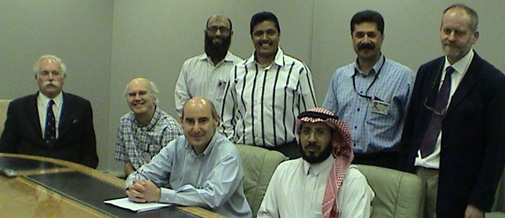
Nic Flemming (L), Abdullah Alsharekh (Front R) & Geoff Bailey (R) with Saudi Aramco staff, Dharran, 2005
DISPERSE: Dynamic Landscapes, Coastal Environments and Hominin Dispersals
Overview
FOR THE NEW PROJECT WEBSITE GO TO:
http://www.disperse-project.org/
DISPERSE is an Advanced Grant awarded by the European Research Council (ERC) for a 5-year programme of research (2011-2016) involving collaboration between Geoff Bailey at the University of York and Geoffrey King at the Institut de Physique du Globe, Paris.
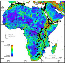
The project will develop systematic methods for reconstructing landscapes associated with active tectonics and sea level change and assess their impact on patterns of human evolution and dispersal. The research will focus on the western Arabian escarpment and the now-submerged territory of the southern Red Sea, including use of remote sensing techniques and field survey on land and underwater, and will also draw on comparative data from adjacent regions in Africa and the Near East. Other collaborators include specialists from the National Oceanography Centre Southampton, the Institut de Physique du Globe Paris, the Hellenic Centre for Marine Research Athens, and King Saud University Riyadh.
Our overall working hypothesis is that conditions of geological instability, despite the potentially destructive risks associated with them, have played a powerful and dynamic role in the development of human society, exercising selection pressures in favour of the early human evolutionary trajectory, and creating potentially attractive conditions for human settlement and dispersal.
Project Aims
- Explore the role of the evolving physical landscape as an ‘agent without intent’ – a set of dynamic forces that has interacted with, selected for, constrained and challenged human adaptive abilities, and explore the relationship between the changing physical landscape and the pattern of earliest human settlement and dispersal out of Africa
- Develop systematic methods for reconstructing landscapes associated with active tectonics and sea level change and assess their impact on patterns of human evolution, dispersal, and social change.
Project Objectives
- Develop techniques for reconstructing the physical morphology of landscapes at a variety of geographical scales, taking account of the geophysical processes that mould and modify the land surface, using new techniques of tectonic geomorphology and a new generation of satellite and digital imagery.
- Investigate the Stone Age archaeology and landscapes of western Arabia and search for new archaeological material on land, with particular reference to the South-western region of Saudi Arabia (Gizan).
- Extend techniques of landscape reconstruction to selected areas of the submerged continental shelf in the vicinity of the Farasan Islands in South-western Saudi Arabia, using acoustic survey, remotely operated underwater vehicles, coring and diving, and assess the local environmental and climatic conditions that may have existed there at lower sea level, and the prospects for discovery of prehistoric archaeological material.
- Undertake a systematic dating and sampling programme of the coastal Holocene shell mounds on the Farasan Islands, which are at the heart of our core region, as a benchmark for what constitutes a fully developed shell mound economy, and as a guide to how to interpret earlier traces of coastal settlement associated with palaeoshorelines that are now submerged.
Project Staff
University of York
- Geoff Bailey: Principal Investigator
- Garry Momber: Research Associate in Underwater Archaeology and Director of the Maritime Archaeology Trust
- : Research Associate in Palaeolithic Archaeology
- : Research Associate in Coastal Archaeology
- : Research Technician in Archaeomalacology
- : Research Associate in Palaeoanthropology
- Niklas Hausmann: Research Associate in Shell Palaeoecology
Institut de Physique du Globe
- Geoffrey King: Co-investigator
- Maud Devès: Research Associate in Tectonics
External Collaborators
- Abdullah Alsharekh, King Saud University Riyadh
- Nic Flemming, National Oceanography Centre (NOC) Southampton
- Kurt Lambeck, ANU, Australia
- Eelco Rohling, National Oceanography Centre (NOC) Southampton
- Dimitris Sakellariou, Hellenic Centre for Marine Research Athens
- Saudi Commission for Tourism and Antiquities
- National Museums of Kenya
NEWS
DISPERSE at the Royal Academy of Engineering's Summer Exhibit - 22-26th June 2013
Research from DISPERSE will be featured as part of the Department of Archaeology's contribution to the Royal Academy of Engineering's Summer Exhibit, 'Design for Living'. Titled 'New Light on the Past', the panels outline the use of 3D and satellite imagery in archaeology in Saudi Arabi, as well as work by Archaeology colleagues in Teffont, Wiltshire.
The exhibit at the Ron Cooke Hub is free to all, and will be open as part of York's Festival of Ideas from the 22nd to 26th June.
Further details and directions here
Complex topography hypothesis paper published in Antiquity - June 2013
DISPERSE researchers in York and Paris have published a paper outlining the theory that complex topography may have been the driver behind bipedalism in early hominin populations.
The full article can be found in Antiquity.
Winder, Isabelle C, Geoffrey C.P. King, Maud Devès and Geoff N. Bailey. 2013. Complex topography and human evolution: the missing link. Antiquity.
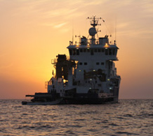
DISPERSE heads back to Saudi Arabia - May/June 2013
The DISPERSE team will be heading back to Saudi Arabia at the end of May for 2 weeks of fieldwork. There will be two components of this work, with the Hellenic Centre for Marine Research ship Aegeo, to map the underwater landscape around the Farasan Islands. Nik Hausmann will also be heading to the Farasan to continue his research into shell seasonality.
DISPERSE on BBC Radio York - 7th May 2013
Team members Robyn Inglis and Matt Meredith-Williams feature on the Archaeology Department's slot on Radio York Drive Time today at 1600. They will be talking about their research on the DISPERSE Project and how it links into the underwater work.
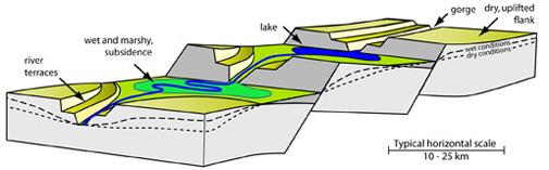
Tectonic Landscapes
Under Construction
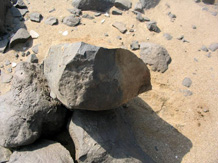
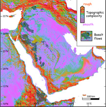
Palaeolithic Jizan
Under Construction
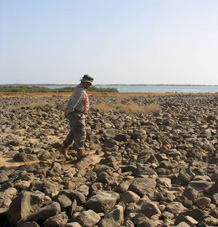
Shell Mounds
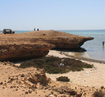
The shell mounds of the Farasan Islands are amongst the most numerous in the world. These sites date to the mid-Holocene (around 5000BP), an interesting period in this part of the world. Better understanding these sites will help inform on what to look for and where to look for earlier evidence of coastal exploitation.
For preliminary results and dating please see the following papers, more in preparation:
Demarchi, B., Williams, M.G.M, Milner, N., Russell, N., Bailey, B., Penkman, K. (2010) Amino acid racemisation dating of marine shells: a mound of possibilities. Quaternary International.
Williams, M.G.M. (2010) Shell mounds of the Farasan Islands, Saudi Arabia. Proceedings of the Seminar for Arabian Studies 40
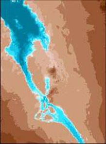
Underwater
The target of underwater work is the submerged landscape around the Farasan Islands, off the coast of Jizan. At present only clow resoution data on the bathymetry exists; the Aegeo cruise will use sonar and seismic surveys to map and interpret this landscape, taking sediment cores in areas of interest.
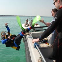
A combination of shallow and deep water diving are used to investigate promsing targets for evidence of prehistoric landscape use.
Publications
Bailey, G.N. 2013. In Press, 2013. Comment on: ‘The antiquity of sustained offshore fishing’. Antiquity 87.
Bailey, G.N., Meredith-Williams, M.G., Alsharekh, A.M. In Press, 2013. Shell mounds of the Farasan Islands, Saudi Arabia. In G. Bailey, K. Hardy, A. Camara (Eds) Shell Energy: Mollusc Shells as Coastal Resources. Oxford, OxBow.
Devès, M.H., Inglis, R.H., Meredith-Williams, M.G., Al Ghamdi, S., Alsharekh, A.M., Bailey, G.N. In Press, 2013. Palaeolithic survey in southwest Saudi Arabia: methodology and preliminary results. Adumatu 27.
Winder, I.C., King, G.C.P., Devès, M. and Bailey, G.N. 2013. Complex topography and human evolution: the missing link. Antiquity 87 (336):333-349.
Bailey, G., King, G., Deves, M., Hausmann, N. B. M. J., Inglis, R. H., Meredith-Williams, M. G., Momber, G. L., Winder, I. C., Alsharekh, A. & Sakellariou, D. 2012. DISPERSE: Dynamic Landscapes, Coastal Environments and Human Dispersals. Antiquity Project Gallery 334
Bailey, G.N. 2012. Dynamic landscapes and human evolution: the last frontier of archaeological discovery. Science and Technology II: 1–2. PanEuropean Networks.
Contact Details
Geoff Bailey Department of Archaeology, University of York geoff.bailey@york.ac.uk
Geoffrey King Institut de Physique du Globe, Paris king@ipgp.fr
A persistent attraction to unstable regions with earthquakes, volcanoes and moving shorelines is deeply rooted in our human ancestry