 Bulletin
1, 1995
Bulletin
1, 1995
The Tarbat Site: Evaluation
Summary
The site at Tarbat Old Church, Portmahomack was evaluated at the invitation of Tarbat Historic Trust, which had been formed to restore the church building. The evaluation was carried out in four stages:
- In Stage 1 (1991)
- a cropmark discovered during the Moray Aerial Survey was investigated with a trench by Jill Harden, who also collected the evidence of earlier discoveries, catalogued it and assessed its significance.
- In Stage 2 (1994)
- the area of the enclosure was examined without excavation by a team from the University of York to see if it contained detectable remains of occupation.
- In Stage 3 (1995)
- a larger area was examined, also non-destructively, using the "strip and map" method, to see if buildings could be defined.
- In Stage 4 (1995)
- the site of the church itself was subjected to a preliminary evaluation.
Table 1: Intervention Index
Intervention |
Location |
Activity |
Originator |
Date |
| 1 | Zone E | Excavation | Harden | 6/91 |
| 2 | Zones D, E | Magnetometer Survey | Lahire | 3/94 |
| 3 | Zones D, E | Resistivity Survey | Lahire Austin | 3/94 |
| 4 | Zones B - F | Contour Survery | Copp Kenny | 3/94 |
| 5 | Zone A | Church Survey | Copp Kenny | 3/94 |
| 6 | Zone B | Churchyard Survey | Copp Kenny | 3/94 |
| 7 | Zone E | Excavation | Carver Roe | 9/94 |
| 8 | Zone D | Excavation | Carver Lahire | 9/94 |
| 9 | Zones B - E | Radar Survey | Sympkins | 9/94 |
| 10 | Zone E | Excavation | Carver Lahire | 9/94 |
| 11 | Zone E | Excavation | Lahire Roe | 8/95 |
| 12 | Zone E | Cropmark Survey | Carver | 8/95 |
| 13 | Zone A | Crypt Clearance | Harden | 92-95 |
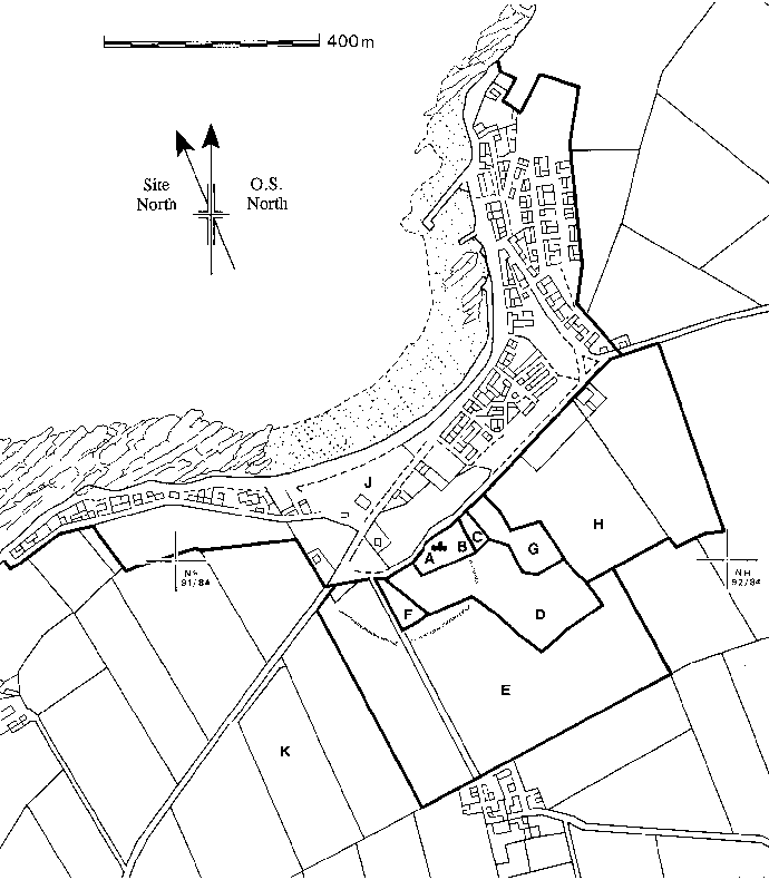
Figure 3: Portmahomack, showing zones for evaluation, Tarbat Old Church and the cropmark.
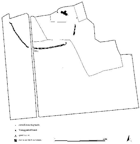
Figure 4: The Tarbat site, showing the Old Church, the cropmark, the location of intervention 1 and the find spots of the inscribed stone and the Viking-period hoard.
The result of this work was the definition of the 'Tarbat Site' as a late Iron Age and Early Historic defended settlement, which probably functioned in turn as an Iron Age stronghold, a Pictish monastery and a Viking-period beachmarket. The architectural development of the church itself remains uncertain. The construction of its crypt had disturbed a Pictish Christian cemetery, its dedication to St. Cholmag (Colman) is probably not without significance, and the site is likely to have seen some of the key political and artistic developments of the Firthlands.
STAGE 1: Evaluation to 1993
Discovery and Preliminary Investigation of the Early Historic Site
by Jill Harden (see also Harden 1996)
Background: The Picts at Tarbat
The seaboard villages of Easter Ross have a special inheritance from the Picts in the form of later (Class II) symbol stones; tall, thin slabs of stone bearing a Christian cross on one face, while still employing Pictish symbols on the other. This is the only area in the Highlands to have more than one such cross-slab within a 5 mile radius. Magnificent stones still stand at Nigg (in the church) and above Shandwick (at the top of the hill). Other stones have been removed from near the chapel at Hilton of Cadboll and the graveyard at Tarbat, to the National Museums of Scotland.
Henderson (1995) has remarked that:
"The[se] more elaborate cross-slabs would seem ..... to belong most naturally to an ecclesiastical context, whether they are memorial crosses to abbots or bishops, or whether they tell us something about the status of the foundation itself. The slabs in Easter Ross certainly suggest that this district supported at least one important ecclesiastical foundation ..... Certainly the[y] require the presence of powerful and artistically ambitious patrons, whether ecclesiastical or secular, around 800 AD."
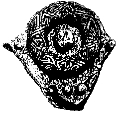
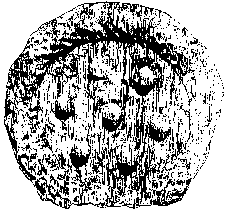
Tarbat itself is unique. The fragments of at least two, if not three, Pictish Class II cross-slabs have been found here in the graveyard [Figs 5-6]. A rare Pictish Latin inscription carved in relief on a stone has also been found nearby [Fig. 7] (Higgitt 1982). This, above all, suggests the presence of an early monastic settlement somewhere in the district. Higgitt (ibid.) suggests that "at Tarbat or somewhere very close by there was an ecclesiastical centre with contacts that went beyond Pictland. .... This centre was capable of producing books ...." Another dozen fragments of Pictish memorials, many of Class III (without symbols) have been found in the Tarbat churchyard or its surroundings. Such a concentration of Pictish Christian sculpture is paralleled at Rosemarkie on the Black Isle and Kinneddar near Elgin, as well as in southern Pictland. Stylistic connections may be made with similar collections of Early Christian stones elsewhere in the British Isles, especially those in the west of Scotland and in Ireland. Here, groupings of non-Pictish carved stone crosses of this period only occur at very important monastic sites, such as Iona or Clonmacnoise. A new Catalogue of the Tarbat stones has been prepared and is published here as the sculpture catalogue.
 |
 |
| IB 131 | IB 283 |
 |
 |
| IB 130 | |
 |
|
| IB 284 | |
 |
|
| IB 285 | IB 280 a-c |
Figure 5: Selected Pictish Class III stones from Tarbat kirhyard and environs
Drawn by J.Reeves after Allen and Anderson.
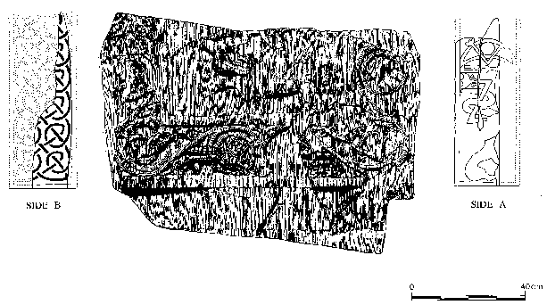
Figure 6: Pictish Class II stone (IB 190) recovered from Tarbat kirkyard.
Drawn by J.Reeves after Allen and Anderson.

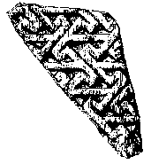
Figure 7: Carved stone with Pictish Latin inscription.
Drawn by J.Reeves after Allen and Anderson
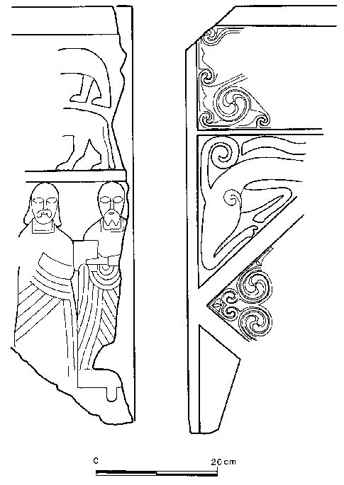
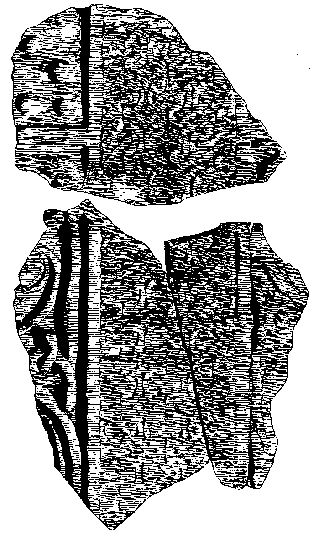
Figure 8: Pictish Class III stone found in the crypt.
Drawn by N.Robertson.
It is therefore possible that the site of Tarbat Old Church is the centre of a Pictish monastic settlement, favoured by a Pictish royal family, whose stronghold is presumably somewhere in this district.
The Vikings at Tarbat
The fragmentary nature of the Pictish cross-slabs found in Tarbat graveyard is itself of interest. Cross-slabs elsewhere in Pictland have generally survived as complete sculptures. Many of the fragments from Tarbat are in an unusually unweathered condition. The implication is that some of them were broken in antiquity, possibly within one hundred years of their production.
Viking raids on monastic settlements, with their sacramental vessels of silver and associated precious items, were commonplace during the 9th century. Lindisfarne, Applecross and Iona all suffered at the hands of the Norsemen. Indeed, the threat of such raids is thought to have brought about the political and cultural amalgamation and subjugation of the Picts by the Scots.
Such wanton destruction could have occurred at Tarbat, if it was a monastic centre, and is probably a reasonable interpretation for the early desecration of more than two Christian cross-slabs here.
A Hoard of the Viking Period
A small hoard of the Viking period was discovered in the graveyard in 1889, possibly having been hidden within a buried stone wall, at least 6 feet below the ground surface (Miller 1889b, Grieg 1940, 109). The silver was found, like so many of the sculptured stone fragments, whilst digging a grave, "some few yards from the east gate of the churchyard". A few weeks after the discovery had been made, the minister of the church investigated the area further. "The supposed line of masonry was reached at about 5 feet from the surface. [The wall is] undoubtably coincident in position with the old wall of the churchyard, which was shifted about 35 years ago". The hoard consisted of two silver penannular armlets and thirteen coins. A further part of this hoard was apparently found in 1892, when digging further graves in the area. The finds were sent to the National Museum of Antiquities of Scotland. Graham-Campbell (1995, 143-4) dates the deposition of the hoard to c.990-1000 AD. The surviving items are:
- IL 272-275
- Four silver penannular armlets
- IL 276
- Silver penny of Edgar (959-975)
- IL 277-281
- Five silver pennies of Louis le Bewgue (877-879)
In 1889 ten pennies of Louis le Bewgue were reported to have been found, as well as one illegible silver penny and another that had broken into pieces. Thus at least seven pennies from this hoard appear to be missing.
Miller and Macleod (Miller 1889b) record that "In this excavation, and in other graves of the churchyard, the earthy mould in which the interments are made is found to extend to a depth of from 7 to 8 feet below the present uneven surface, resting on white sand. The bottom of this considerable growth of mould [earth] probably represents .... the original surface of the ground , the native soil of which in so bleak a spot was doubtless very thin."
"Over considerable spaces of the churchyard, some thirty paces from the east and west gables [of the church], the spade of the grave-digger passes through a layer of shells of edible species..... The date of this early occupation it is impossible exactly to fix."
The church therefore stands on a hill of sand surrounded by a graveyard now about 8 feet (2.5m) deep.
The Aerial Photograph [Fig. 3, 4]
In 1984 Jones and Keillar recorded a large irregular enclosure centred on Portmahomack harbour and extending beyond the parish kirk. This linear feature c.4-5m wide runs NE-SW and then turns through 120 to run SE-NW, c.150m to the south and west of Tarbat Old Church.
There are a variety of possible explanations for this feature. However, bearing in mind the numerous Early Christian Pictish stone fragments from the graveyard and the geographical location of the linear feature, the most probable is that it is a vallum around a monastic settlement, such as those already known at Iona or Hoddom (Lowe 1995).
Test Excavation 1991 (INTERVENTION 1)
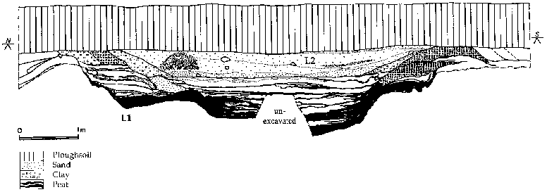
Figure 9: West facing section of Intervention 1.
(J.Harden)
In June 1991 a small archaeological excavation was undertaken by the author to investigate the nature of the ditch and date its fills. Permission to investigate the linear feature was granted by the landowner, Mr W. Gordon, and grants were received from the Society of Antiquaries of Scotland and from Ross and Cromarty District Council.
The Excavation
Method :
The probable location of the ditch was estimated and a narrow (0.7m wide) trench then dug by hand across it at a point at the edge of the south field adjacent to the road [Fig. 4]. Having located the edges of the ditch, an area 4m x 10m was laid out and the modern ploughsoil (0.8m deep) was removed manually.
The exposed surface was cleaned and the sectioning of the ditch was then considered, bearing in mind the safety implications of the height of the baulks. Finally a long section 1.5m wide and 8.75m long was excavated across the ditch.
However, at a depth of 1.7m, the water table was reached. It was therefore decided to use a pump to remove the water from a small test pit. This allowed us to record the depth of the ditch and take samples of the organically rich layers at the bottom of the feature, without the need for shoring or a sump. Thus the long section across the ditch was not fully excavated during this season's work.
Results :
The linear feature had been cut into the natural windblown yellow sands, and at some stage had been dug to such a depth that the underlying pink sand with cobbles was also disturbed. But, without the benefit of a wider excavation trench, shoring, and an efficient pump and sump, it is impossible to be certain of its original size and form.
The following interpretation of the rapidly recorded section is therefore questionable, but provides an indication of the use of the linear feature and its long life as a boundary in the agricultural landscape of the area.
It should be noted that it is extremely difficult to assess the level of the original ground surface, because of the varied nature of the impact of the addition of windblown sands in the vicinity. The suggested depths of the various ditch cuts are therefore from the present line between ploughsoil and archaeological strata. The stated ditch depths are thus less than they would have been when first dug.
The only part of the first cut of the linear feature to have survived was recovered at the northern edge of the trench. This was the southern edge of a ditch which appeared to run parallel to the main feature, but was not investigated further. However, closer examination of the aerial photograph does show this second narrow ditch, recorded as an intermittent cropmark running along the 'inside' of the main feature.
The next cut recorded in the section appears to have been wide and comparatively shallow, (c.6m broad by at least 1m deep) [Fig. 9]. The grey silty sand deposits filling the first ditch to the north and covering the area to the south are presumed to be the remains of the upcast from this recut. It is thus assumed that there was an inner and outer bank.
The dark silty organically rich layer (L1) forming the primary fill of the cut was sampled for dating purposes and palaeobotanical analysis. This layer was sealed by a series of windblown sand deposits and alternate silty sand layers, presumably representing periods of stabilisation and/or waterlogging.
The ditch was recut before it had become completely filled in, but to a completely different profile and along a slightly different line. The cut was c.4m wide and c.1.2m deep. This time the underlying pink sand with cobbles was certainly disturbed, and thrown up to create parts of the inner and outer banks. Again, the dark silty organically rich layer forming the primary fill (L2) was sampled for dating purposes and palaeobotanical analysis. This layer was also sealed by a series of windblown sand deposits and alternate silty sand layers, presumably representing periods of stabilisation and/or waterlogging.
The section across the outer bank revealed two deposits of pink sand with cobbles, suggesting that this form of the ditch had been recut. However, this was not indisputably confirmed in the recording of the ditch fills.
The final recut created another wide and comparatively shallow ditch, (c.5m broad and at least 0.8m deep). Its primary fills were of alternate layers of organic-rich silts and windblown sands. The secondary fill was a series of dark sandy loams.
Areas within these secondary layers and in the upper layers of the redeposited sands to either side of the ditch cut had been affected by some sort of oxidising of the sand around root holes and air pockets. Initially these deposits had been interpreted as debris from furnaces of some sort. However, a rapid assessment in the laboratories of the AOC determined that they were natural concretions of some sort or other.
The remains of the linear feature were sealed by the ploughsoil, which contained a range of pot- sherds and other fragments which are all post-medieval in date. None of the underlying deposits had produced any artefacts.
Conclusions:
The ditch must have been an important feature in the landscape for a considerable period. It had been recut on at least five occasions and the effort that went into such events in terms of manpower, must have been significant.
The section across the ditch produced no artefacts, but the ploughsoil above contained post-medieval potsherds and other fragments. It is therefore presumed that the feature is pre-17th century. Organic-rich samples taken from the primary layers of the recuts were dated by radiocarbon.
The Radiocarbon dates
The dates were received in November 1992. There is 95% certainty that the dates fall within the following brackets: 140-410 AD, 250-531 AD, and 350-590 AD.
The dates suggest that an enclosure had been created at Portmahomack in the early Pictish period. It is possible that the area within the ditched boundary was used as a settlement, craft-working centre and/or hub of a Pictish community. The later evidence of the Pictish Early Christian carved stones would suggest that the area became a monastic enclosure sometime after the middle of the 6th century AD.
STAGE 2: Evaluation in 1994
by Justin Garner-Lahire
The aims of the evaluation programme were to map the extent and character of the Tarbat site and to propose a programme of work which would answer current research questions. This is achieved by matching a "deposit model" with a "research agenda", showing which questions would be answerable by archaeological investigations at this site. The proposed programme of work is given as a "project design".
Deposit Model
Zones A-F were selected for detailed deposit modelling [Fig. 3]. This area contained both the church and the cropmark and was not greatly disturbed by modern development. Topographic and geophysical survey programmes were carried out in late March 1994, while test excavations were undertaken in the summer of 1994 and 1995 [Fig. 10-16]. The test excavations were carried out with the kind permission of James and Douglas Gordon, Billy Vass and the Church of Scotland.
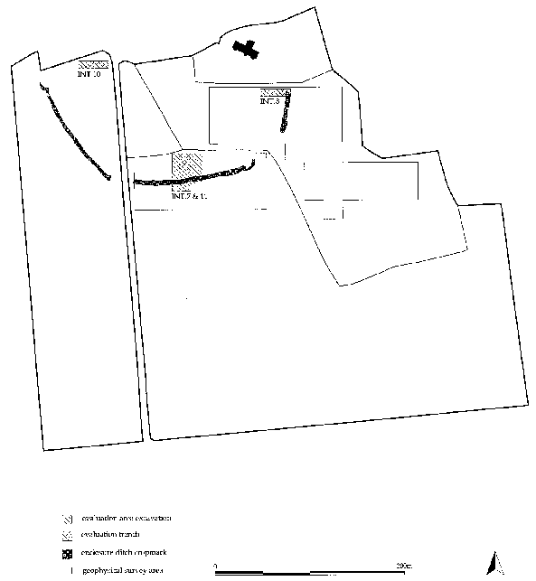
Figure 10: Deposit Modelling: geophysical survey and evaluation excavations.
Topographic Survey and Feature Mapping (INTERVENTIONS 4 - 6)
The results of the topographic survey form the basis of the deposit model. The contour map provides a surface model which can be used to assess strata capture and therefore gives some insight into the likely state of preservation of archaeological remains within a given area. Mapping features such as buildings, boundaries, gravemarkers and trees produces a plan of known potential disturbance to archaeological remains as well as providing a valuable management tool for the planning of future interventions.
Data points were recorded, using a total station theodolite (Wild TC1010), throughout Zones B-F (Int.4). A contour map was then generated, employing Liscad plus SEE digital terrain modelling software, which was then output at 0.5m vertical intervals [Fig. 11]. A similar procedure was used to produce a plan of the Old Church (Zone A, Int.5), and a map of gravestones in the old part of the churchyard (Zone B, Int.6).
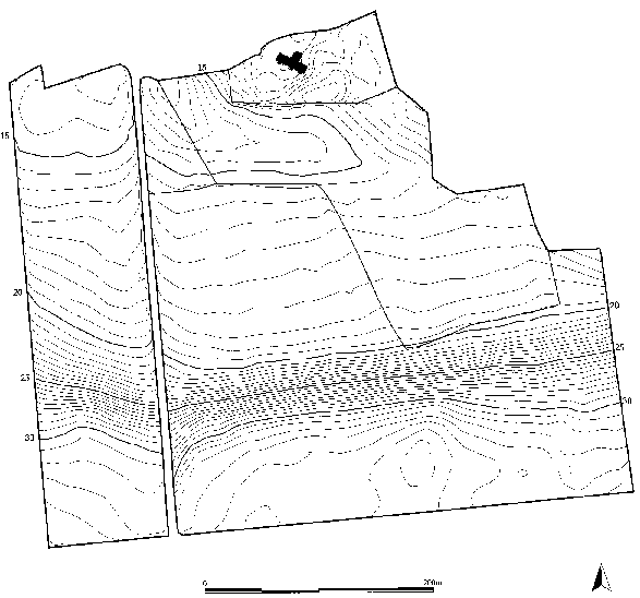
Figure 11: Deposit Modelling: topographic survey.
Geophysical Survey (INTERVENTIONS 2, 3 and 9)
Areas within Zones D and E were selected for detailed magnetometer and resistivity surveys. Unfortunately the western field of Zone E was unavailable due to the presence of an immature grass crop. The western end of Zone D was found to be unworkable, as this low lying area was poorly drained, and the weather extremely wet. The survey was therefore confined to the eastern side of the enclosure [Fig. 12].
The magnetometer survey (Int.2) was carried out using a fluxgate gradiometer (FM18 - Geoscan Research) with a sample trigger (ST1). A standard-resolution area survey was undertaken (readings taken at 1.0m x 0.5m intervals). It had been hoped to carry out a higher-resolution survey; however, adverse weather conditions including gale-force winds and dramatic changes in temperature made a consistent high-resolution survey an impossible objective within the available time.
The results of the magnetometer survey confirmed much of the information derived from the aerial photographs [Fig. 12]. This is particularly true of the survey area in Zone E, where modern field drains, medieval furrows and the length of east-west orientated enclosure ditch are clearly visible. To the north, in Zone D, the north-south length of the enclosure ditch is less clear, and is only visible as a strong anomaly at the northern edge of the survey area, once again reflecting the aerial photographic evidence.

Figure 12: Deposit Modelling: Fluxgate gradiometer survey.
In Zone E the magnetometer detected a large concentration of magnetic anomalies on the interior side of the enclosure ditch. Although none of these anomalies were readily identifiable by their form, their strength indicated the likely presence of fire-related features or deposits. In Zone D a larger and more obvious concentration was detected to the south of the churchyard wall. Once again, the magnitude of these anomalies suggested the presence of fire-related deposits or objects such as buried iron. Unlike the concentration of anomalies to the south, this group does not seem to respect the enclosure ditch and continues to the east of the survey area. At this stage it seemed probable that this concentration represented later medieval or post-medieval activity, as its position and orientation related to the churchyard wall rather than the enclosure ditch.
A standard- resolution resistivity survey (readings taken at 1.0m x 1.0m) was undertaken using a Geoscan RM4 resistance meter with a 0.5m twin probe mobile array (Int.3). Good results were not expected from this survey as the very wet weather conditions were likely to make the moisture differential between archaeological deposits and the subsoil negligible. It was hoped, however, that the resistance meter would detect large features.
The results of the resistivity survey demonstrated that the resistance meter was able to detect large features, even under such difficult conditions. In Zone E the enclosure ditch was clearly visible, as were the medieval furrows in both Zones D and E. This survey also supported the earlier observation, derived from magnetometer and aerial photographic evidence, that the medieval ridge and furrow system respected the enclosure, with furrows terminating on top of the ditch, rather than continuing into the interior. The resistivity survey identified no features which had not already been mapped using other techniques.
In the summer of 1994 a team from Oceanfix International Ltd led by Peter Sympkins kindly agreed to undertake a ground-penetrating radar (GPR) survey at Tarbat (Int.9). Unlike the methodology employed for the magnetometer and resistivity surveys, the GPR was used to produce profiles or vertical slices through the ground in order to assess deposit depth and complexity.
A series of profiles was taken across the churchyard (Zones B and C). It was hoped that the radar would be able to map any deeply buried stone structures, such as the one associated with the discovery of the Viking Period hoard in 1889 (above). Unfortunately, due to the high level of disturbance caused by burial, along with reflections from surrounding grave markers, it was not possible to isolate any deeply buried features which could be interpreted with any degree of confidence.
The results of a long east-west profile carried out immediately to the south of the churchyard wall (Zone D) indicated the presence of deep and relatively complex deposits beneath the surface of this area of high ground. This corresponded well to the situation encountered in the nearby evaluation trench (Int.8), the excavation of which was already underway during the GPR survey.
Several north-south profiles were undertaken across the east-west orientated length of enclosure ditch in Zone E. This survey demonstrated a gradual increase, from east to west, in the surviving depth of the enclosure ditch, which suggests that Int.1 had sampled the enclosure ditch at one of its deepest points, in an area of good preservation.
Test Excavations
The principle for Test Excavations was that they should, as far as possible, not destroy any early features. The technique employed was therefore to remove the ploughsoil, clean the surface of the buried features until they could be clearly defined, and then record them without excavation. The level at which this was done was termed "Horizon 2" and generally coincided with the level of the subsoil. The term "Horizon 1" was reserved for features definable within the ploughsoil itself. After recording by plan, photograph and written description, the surface was covered with a layer of plastic sheeting and reburied. This tactic, known as "strip, map and wrap" allows large areas of a relatively shallow site to be confidently evaluated without damage. The same technique is also to be used in the data acquisition phase which is to follow evaluation, for mapping large areas which are required by the research design but are not to be intensively excavated.
INTERVENTION 7 1994 [Fig. 13]
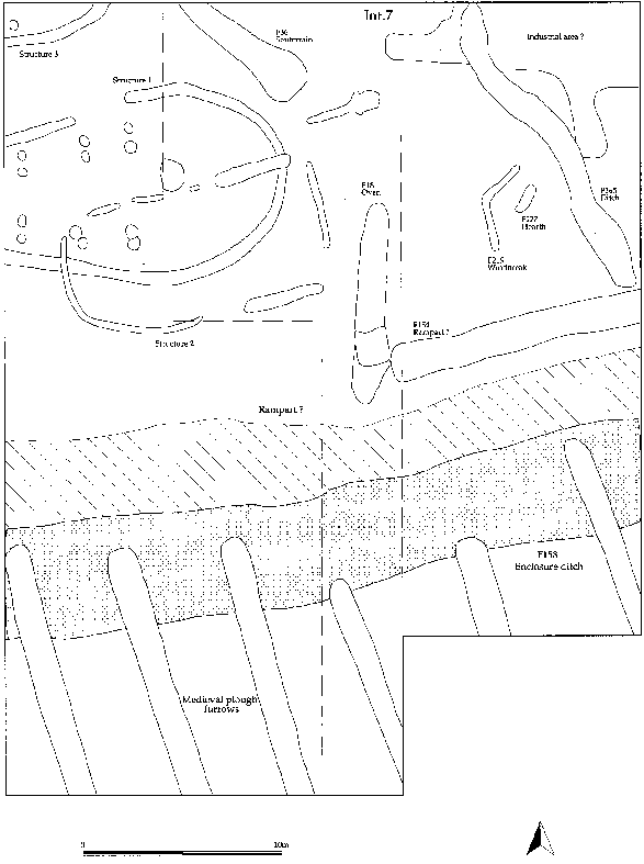
Figure 13: Plan of Intervention 7/11
This intervention measured 12m x 16m and was positioned to test the interior of the enclosure on the southern side, where several strong anomalies were identified during the magnetometer survey, and where a concentration of stones was noted on the surface during field survey work. An area of 4m x 24m was also extended southwards to test the full width of the enclosure ditch.
The area was stripped by machine, except for one 4m x 8m quadrant which was excavated by hand in order to test for finds recovery within the ploughsoil. Although a depth of 0.8m of ploughsoil was expected following the results of Int.1, stone features were already showing here at only 0.3m below the modern ground surface.
The Enclosure Ditch
The ditch, as defined at Horizon 2, was seen as being c.6m wide with a dark pink compacted sand shoulder on its northern edge, a pale grey sandy fill showing along its southern edge, and between these its latest backfill, a blackish brown silty soil with many fragments of shell. Cutting this latest fill and running southwards from the ditch outside the enclosure, were the furrows of the system of medieval ploughing (seen so clearly in the gradiometer survey), one of which was planned and excavated.
Inside the enclosure ditch there was a very high concentration of features, the majority being postholes which are difficult to interpret in a restricted excavation area, but which do indicate more than one phase of activity on this site. Of the larger features encountered, most continued outside the area, and it was decided to empty two fortuitously positioned modern field drains which cut through them in order to determine their depths and the nature of their fills from the section.
Building, Structure 1
The feature which produced the stones seen during survey first appeared as a semi-circular structure (Structure 1 on Fig. 13), c.10m across at its widest point, and continuing westwards. The structure consisted of a gully 50-60cm wide packed with cobbles and large stones in a black-brown silty soil. The stones on the surface of the feature were somewhat disturbed by the plough, making it difficult to define the nature of this gully. In places it appeared as a series of postholes with stone packing, rather than a continuous trench. The section offered by the excavated field drain through this feature showed it to have a U-shaped profile and a minimum depth of 30cm. On the basis of Int.7, the structure was initially interpreted as a "roundhouse".
Souterrain, F36
To the north of Structure 1 was a broad linear feature orientated NW-SE c.1m wide ending in a slightly wider pit. The pit was characterised by a number of large fragments of sandstone tipping into the fill towards the centre, and a high concentration of cobbles such as those used in the construction of the house. These stones were all in a homogeneous black-brown silty soil. Here the section given by the field drain suggests a depth of at least 30cm, but gives the impression that it may be a good deal deeper. This feature may be interpreted as a souterrain or underground storage associated with the house; it may be similar to the structure excavated on the other side of the Firth (Pollock 1992).
Oven/hearth, F18
To the east of the house was another interesting feature, and clearly the reason for one of the strongest anomalies on the gradiometer survey; a rectangular platform of compacted pink sandy clay with pebbles at the southern end of an 8m long, 1.5m wide shallow gully backfilled with deposits of charcoal-rich silt. Although the clay platform showed no sign of burning, this feature appears to be a type of oven structure with a flue or channel for cleaning.
Industrial Area?
Another area of activity was recorded along the northern section of the intervention, where there appears to be a hollow or depression filled with mixed redeposited natural subsoil and various deposits of charcoal-rich soil, as well as a concentration of fragments of slag which may indicate the presence of metal-working in the vicinity. This depression also indicates an increase in deposit depth towards the north and into Zone D.
In conclusion, it seems that the area immediately inside the enclosure ditch is extremely complex, with a variety of different activities, none of which could be fairly assessed within the limits of this intervention. The area of the ditch itself showed a number of different fills, and the hint of rampart along the inside which really needed to be seen in a larger area to confirm its existence. The area outside the ditch, although it seemed to contain only late medieval agricultural features was not a large enough sample to exclude the possibility of the presence of earlier activity. Accordingly, in 1995 the surface mapping was extended to a larger test area, Int.11 which contained Int.7 [Fig. 13].
INTERVENTION 8 1994 [Fig. 14]
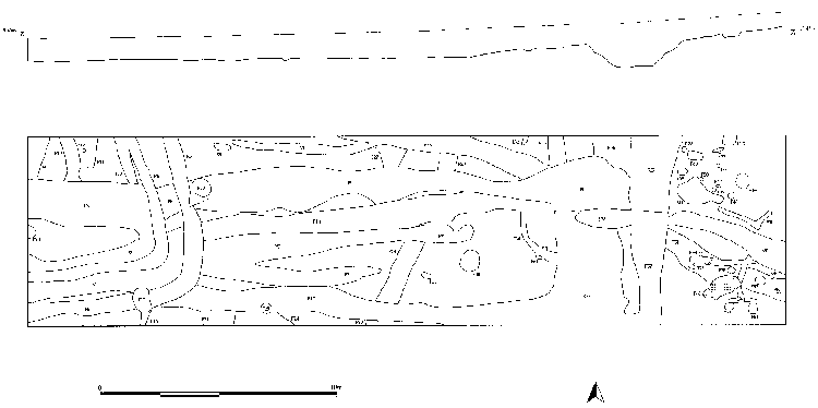
Figure 14: Plan and Profile of Intervention 8
This 8m x 32m area was located immediately to the south of the churchyard wall in Zone D [Fig. 10]. The objective of positioning Int.8 in this area was threefold; firstly, to investigate a high concentration of magnetic anomalies detected during the magnetometer survey, secondly, to expose a length of the enclosure ditch on the eastern side of the enclosed area, and thirdly, to test the area of high ground upon which the Old Church and churchyard are situated.
Topsoil
The topsoil varied in depth from 0.3m at the eastern end of the intervention to 0.6m at the western end, and was found to contain two separate plough horizons. Beneath this ploughsoil an uneven horizon was defined (Horizon 1), characterised by dense concentrations of charcoal or shell, both with frequent fragments of slag. This horizon was rapidly assessed during the on-going removal of the topsoil, and was found to vary in thickness (0.05 - 0.3m) and share an uneven interface with the underlying layer. The mixed deposits which made up Horizon 1 sealed a further two probable plough horizons (0.1 - 0.4m thick), the later of these containing several sherds of glazed pottery of the 14th - 16th centuries. These finds indicated a late- or post-medieval date for Horizon 1. Given that these deposits were well-represented in section, it was decided to remove the Horizon 1 deposits and most of the underlying ploughsoil by machine (recovery level A).
Medieval or Post-Medieval Rubble Features
During the machining two possible stone structures were identified. The first structure, located at the western end of the intervention, consisted of a 2.0m long and 0.8m wide alignment of stones, orientated north-south (F1). A shorter alignment (F2), 1.0m long and 0.7m wide, formed a right- angle with, and ran east from, the longer one. Both alignments consisted of two parallel lines of stones forming a single-course 'wall' made from large roughly-hewn or unworked blocks of sandstone, with a sand infill. No bonding material was identified. The function of this structure is uncertain; however, its close relationship to Horizon 1 suggests it may have been associated with ironworking or other activities related to the presence of large quantities of shell, charcoal and slag.
The second possible structure was located at the eastern end of the intervention and consisted of a 5.5m long and 1.0m wide (maximum) alignment of stones (F3). Although this alignment had fairly well defined edges, it was otherwise disordered in appearance. Once again, there was no evidence for any kind of bonding material. When this feature was originally identified, it was considered to represent the remains of a crude structure, such as a windbreak, associated with Horizon 1 activity. However, with the definition of F38 at Horizon 2 [Fig. 14], with which F3 shares a similar orientation and form, this alignment of stones was thought more likely to be the rubble fill of a linear negative feature, the edges of which were not recognised at Horizon 1.
The remaining ploughsoil was removed by shovel (recovery level B) and coarse trowelling (recovery level C) to arrive at the subsoil interface (Horizon 2) at a depth up to 1.2m below current ground level. Features 1, 2 and 3 were then cleaned, photographed, planned and removed. The intervention was divided into 4m x 8m quadrants which were individually fine-trowelled, photographed and planned.
Early Features
The subsoil encountered at Horizon 2 consisted of a clean, white, fine sand which was quickly dried and displaced by the wind. However, this was found not to be the case at the eastern end of the intervention, to the east of F37, where the subsoil was made up of a coarse, compacted and oxidised orange sand, similar in character to the subsoil of Interventions 7 and 10.
Several features defined at Horizon 2 were identified at an earlier stage of the operation. Two charcoal- and sand-filled pits, F15 and F19, were first seen during the removal of the Horizon 1 deposits and were clearly related to this later phase of activity, as is most probably F38.
As anticipated, the enclosure ditch was located at the eastern end of the intervention. This approximately 4.0m wide north-south orientated feature was made up of several definable deposits; each of these was assigned a feature number as it was not certain whether these contexts related to separate cuts, or a were a complex of deposits filling a single cut (F35-37). This was further complicated by the presence of several later features such as F8 and F38; in some cases, for example F17, it was not possible to distinguish their fills from those of the enclosure ditch.
In an attempt to clarify this situation, a 1.0m section of the enclosure ditch was sampled (recovery level C). This sample was taken against the north section of the intervention. C1050 (F36) and C1051 (F37) were found to fill a single deep cut (1.0m from Horizon 2) with gradually sloping sides. The bottom of the cut was flat; however, 0.3m south of the intervention edge an almost vertical step had been cut into the subsoil which reduced the depth of the ditch by 0.35m. It was suggested that this decrease in depth may indicate the presence of an entrance or causeway further to the south. Unfortunately, no dateable artefacts were recovered from the sample.
To the west of the enclosure ditch, Horizon 2 was dominated by a large number of linear features which seem to fall into three main groups; the latest group consists of two parallel gullies (F5-6) which enter the intervention in the south-west corner, run east for 6-7m before turning through ninety degrees and running under the north section of the intervention. The second group is made up of seven separate lengths of linear feature (F7, 8, 17, 18, 22, 23) all of which are orientated east-west. At the eastern end of the intervention this group consists of two broad features (c.1.5m) (F7-8), which split into five separate irregular shaped linear features, forming a system that appears to terminate over the enclosure ditch. The earliest group is characterised by several gullies which contain a grey mottled sand fill (F10, 27, 28, 29). The fact that a similar gully (F54) is cut by the enclosure ditch on its eastern side suggests that the earliest group of gullies to the west is also earlier than the enclosure.
A section line was set out parallel with, and 1.0m to the east of the western edge of the intervention. Selected deposits on the western side of the section were excavated, providing a 1.0m sample of F5-8. F5 and F6, which form the latest group, proved to be very shallow (0.1m) and contained no datable material. It was therefore still uncertain whether these features were plough furrows or the gullies of an enclosure, or even a double-ditched enclosure. Features belonging to the second group (F7 and F8) were found to be more substantial. In the case of F7 possible spade-marks were visible in the base of the feature, while F8 was made up of three separate gullies or furrows. All these features are likely to be related to agricultural practices, being either plough furrows, drainage gullies or field boundaries.
To the east of the enclosure ditch, that is outside the enclosure, a different range of feature types was defined. Apart from the two gullies, F38 which is later than the enclosure ditch and F54 which is earlier, a concentration of structural features were identified. Most of this concentration consisted of postholes and small pits; however, several narrow linear features set at right-angles to each other were also present (F51, 55, 61). The southern group of these linear features was closely associated with a stone platform (F60), which was made up of several large blocks of unbonded stone, the upper surfaces of which formed a flat surface. These linear features and associated postholes have been interpreted as the remains of small wooden structures, possibly to provide shelter for industrial activity. In this case the stone platform may have been the base for a hearth or working surface.
The results of Intervention 8 were rather unexpected, providing evidence of agricultural activity in the interior of the enclosure and structural evidence in a small area examined outside the enclosure. It is important to note however, that the white sand subsoil encountered to the west of the enclosure ditch is a superficial layer, probably of windblown sand. This was clearly demonstrated during the sampling of the enclosure ditch. It is possible that this layer fills a natural depression and is masking earlier archaeological remains. Unfortunately, it was not possible to test this hypothesis.
Intervention 8 did demonstrate that the area around the church is made ground, the ground level having been built up dramatically during the medieval and post-medieval periods. This high ground with its deep, fairly well-preserved deposits, is capable of reporting on a long sequence of activities sandwiched between episodes of deposition and ploughing.
INTERVENTION 10 1994 [Fig. 15]
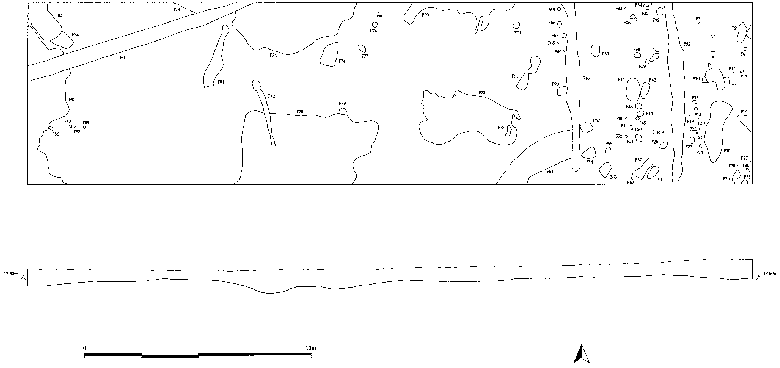
Figure 15: Plan and profile of Intervention 10
This area, 8m x 32m, was opened on the western side of the enclosure [Fig. 10] as far north, and therefore as close to the sea, as was possible within the immediately available area. The topographic survey (Int.4) had shown this area to be relatively low lying (<14m AOD) and potentially a "trap" for well-preserved deposits.
The ploughsoil was found to be relatively deep (0.5-0.7m) within which three plough horizons were recognised. The lowest of these horizons was cut by several fairly shallow (max. 0.45m) irregular depressions which measured up to 6m x 3m (F78, Fig. 15). These features were backfilled with a very dense dark brown clay silt. Initially it was hoped that these features represented the worn interior surfaces of buildings; however, the fills contained no evidence of occupation debris and no structural evidence, such as postholes, was found which clearly related to these depressions.
At the eastern end of the intervention a large number of postholes were identified along with several pits lined with charcoal. Given the limited size of the area in which these features were observed, it was not possible to interpret their function.
Modern drainage related features were predominant in Intervention 10, with one large field drain at the western end (F80) and two features which are either field drains or the result of sub-soiling at the eastern end (F46 and F92), as well as several other linear features which are also probably related to drainage. This suggests that this area is poorly drained, even though its underlying subsoil is sand, which may be a result of the water retaining fills of the large depressions.
STAGE 3: Evaluation in 1995
The third season of evaluation concentrated on surface mapping of the features located in Int.7. This was undertaken over a large area in order to raise confidence that a substantial late prehistoric/early historic settlement had been discovered and that its investigation would be rewarding. The evaluation was again non-destructive, using the "strip, map and wrap" technique. The area examined extended to 32 x 40m (Int.11, Fig. 13), and included Int.7 within it.
Method
The methodology was adapted in the second season according to information gained from the results of Int.7. Three-dimensional plotting of finds in the ploughsoil had suggested that artefacts derived from truncated features in the lower portion of the ploughsoil had not been significantly dispersed, but remained in a position relative to their feature of origin.
On Int.11 the ploughsoil was still machined away (recovery level A) but to a lesser depth stopping at approximately 20cm above Horizon 2, thereby reducing the risk of disturbing stone structures during machining. A high-resolution (1m x 1m) magnetic susceptibility survey was then undertaken across the stripped surface. The remaining ploughsoil was removed by shovel (recovery level B), then by coarse trowelling (recovery level C), in order to arrive at Horizon 2, the level at which it proved possible to define the archaeological features by fine trowelling (recovery level D). All finds were plotted three-dimensionally regardless of the recovery level in operation. The site was then divided into 8m x 4m modules, which were individually fine-trowelled, photographed and planned.
This methodology provides an opportunity to recover valuable information from the base of the ploughsoil which is in part made up of the components of disturbed and illegible archaeological deposits. The large material assemblage derived from the ploughsoil does not merely enhance any subsequent assemblages recovered through the excavation of undisturbed deposits, but, in conjunction with the results of the magnetic susceptibility survey, may also allow us to crudely reconstruct the more superficial deposits which have not survived the ploughing episode. The fact that information obtained from the ploughsoil may reduce the need for such extensive sampling, and therefore destruction, of undisturbed archaeological remains is a further important justification for this approach and for its associated allocation of resources.
Results
Approximately 250 features were mapped in Interventions 7 and 11, although the function of many of these features will remain uncertain without detailed excavation. For the purposes of this report only the major features are presented in order to show the complexity of the site and its broader phases.
Prehistoric Cultivation
The earliest levels encountered in this area are all related to agricultural activity before the construction of the enclosure ditch. Evidence for this comes from a patchy but coherent layer of pale grey podsolised sandy ploughsoil which survives to a depth of up to 5cm, particularly in the south-western part of the site where it is also characterised by concentrations of iron pan. Where this layer does not survive, to the east where the natural subsoil is higher and therefore more damaged by the modern plough, it is still possible to see the scars of the plough in a criss-cross pattern on the yellow subsoil. Other features associated with this phase are shallow gullies, orientated predominantly east-west, and backfilled with the same pale grey sand which may represent field boundaries or tracks, or which could just be furrows from deeper ploughing in the same system.
Defensive system of the enclosure
The ditch and bank seen over a length of 32m show greater complexity than previously seen in Int.1 and Int.7. The ditch shows at least two phases: originally c.8m. wide, it was backfilled and recut in a second phase with a narrower ditch. Parallel features on the inside of the ditch will probably be shown to derive from one or more phases of ramparts.
Buildings
Within the enclosure, at least two phases of building have been defined, the earlier of the two being the anticipated "roundhouse" identified in Int.7. This structure (Structure 1 on Fig. 13) turned out not to be round at all, but rather the shape of an elongated horseshoe, symmetrical along an east-west axis, at least 14m long and continuing westwards beyond the edge of the excavation. Inside the building are a pit, or possible hearth, central to the widest part of the house, and a series of double postholes, possibly for roof supports, along the inside of the walls.
Cutting through the walls, or rather the stone-filled foundation trench of Structure 1, was a second structure (Structure 2 on Fig. 13) composed of a series of small gullies and postholes, several of which were recorded in Int.7 but not recognised as a building. The whole is a large rectangular structure with slightly rounded corners at the western end c.7m wide and 13.5m long orientated east-west in the same way as Structure 1.
In the north-west corner of the intervention was another foundation trench (Structure 3 on Fig. 13) similar to that of structure 1, with one possibly associated posthole. It is probable that the feature interpreted as a souterrain in Int.7 belongs to one of these buildings.
Industrial Area
To the east of these buildings is an area containing features of a possible industrial character: an angled gully (F219) which could be a windbreak, with a hearth and disturbed redeposited natural sand mixed with concentrations of charcoal on its leeward (eastern) side; to the north of this an area of pits and gullies backfilled with stone and brown charcoal-rich silt with, in one of the pits, a high concentration of slag and a fragment from a small mould. Cutting across this area is a curving trench backfilled with dark grey sand and large fragments of sandstone which tip down towards the centre. This trench stops short of the putative rampart and may belong to a later agricultural phase.
The latest features to be recorded are a series of plough furrows belonging to the system of medieval ridge and furrow recognised on the geophysical survey and tested in Int.7. These are approximately 1-1.5m wide and about 4-5m apart, running NW-SE. They cut the latest backfill of the enclosure ditch but do not extend beyond the hypothetical rampart. This suggests that the ditch and bank either survived as an earthwork or was remembered as a boundary in this period.
Parch marks, INT 12
The 1995 season was undertaken during one of the hottest summers on record, which meant that the grass in the field around Int.11 was parched and brown except along the line of the larger archaeological features [Fig. 16]. This provided an opportunity to map the continuation of the enclosure ditch (F6) to the east and the south-eastern corner of the enclosure where the ditch seems to butt-end, but a smaller gully (F7) continues northwards which may represent the position of an entrance.
Outside the enclosure to the south the medieval ridge and furrow (F1) showed very clearly and to the south east of the enclosure were several other features. These include a sub-circular gully (F9), c.4.5m in diameter, with a central pit (F10); a curvilinear gully of uncertain function (F11); and a large sub-oval feature orientated NW-SE, c.18m long and at least 11m wide, characterised by a ditch or gully c.1-2m wide (F8).
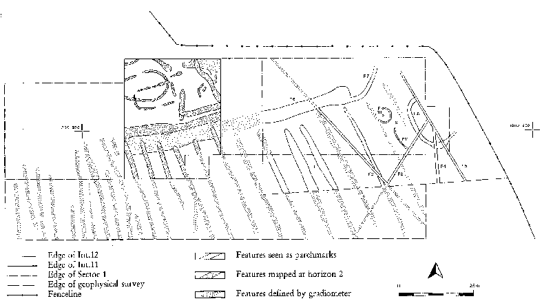
Figure 16: Plan of Sector 1 showing the results of Interventions 2,11 and 12.
STAGE 4: Evaluation of the Church Site
Martin Carver, Jill Harden and Geoffrey Stell
The Church Building Fig. 17]
by Geoffrey Stell (1986)
By virtue of its position at the centre of such an interesting and important parish, the T-plan church of Tarbat has many points of architectural and social interest. The main body of the church has an elongated rectangular plan fairly common in the north-east of Scotland. Like many of them, it is generally assumed to be a post-Reformation creation, and in this case the date of the church is given as 1756 in the late 18th century Statistical Account of the parish. The church has a bland harled exterior with small chamfered windows. However, its appearance is deceptive and it is worth noting that the main block of the building is orientated east-west in medieval fashion. It is reasonable to assume that it is laid on, or guided by, older foundations.
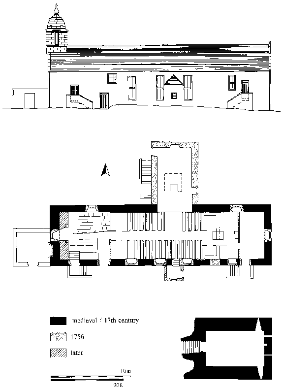
Figure 17: Tarbat Old Church: South elevation, plan of ground floor and
crypt
(Drawing based on the RCAHMS survey plan, 1982)
The dedication is a medieval one, and is to Bishop, later St. Colman, whose name is also found in less obvious form in the last syllables of the name Portmahomack itself. The Bishop's name can also be found in the Kalendar of Fearn under the date of 15th February. Moreover, underneath the east end is what appears to be a genuine late medieval vaulted crypt which takes up about one third of the length of the church. It has an aumbry in the east wall, and there are four deep embrasures leading down from slits or vents at ground level. The aumbry may possibly have been associated with an altar. The vaulting shows evidence of plank centering, and there is a mason's mark on the doorway. The crypt was first noted in the first half of the 18th century before the alleged building of 1756.
Its medieval origin seems well attested, but just how early the existing building might be is hard to say. A church has been on record here from at least 1255, although no architectural remains of that period have been identified. It was then probably served by one of the canons of Fearn to whom the vicarage revenues had been assigned by 1274. However, the numerous early cross-slabs and symbol stones that have come to light around this churchyard, together with the accidental discovery in 1899 of a Viking silver hoard a few yards from the east gate, show that the site has many known, and probably just as many as yet unknown historical associations. The silver hoard was found whilst a grave was being dug close to a pile of hewn stones lying parallel to the church and churchyard. Almost all the finds are housed in the National Museum of Antiquities, Edinburgh, and a recent survey has added to this record. A fragment of a (early) medieval carved stone with plaited decoration on the visible surface was found re-used at the west end of the church. It was incorporated into a blocked-up arch which formed part of a later colonnaded screen and entrance, subsequently converted to a window and partly infilled to provide a strengthened substructure to the belfry. The stair and belfry were also reconstructed employing a number of baulks of boats' timbers still bearing pegs and sockets which now have no structural purpose. Such timbers were also used as bearers for the bell; these are of uncertain antiquity. An inscription on the bell itself records that it was made for the church of Tarbat by John Milne of Edinburgh in 1746 and was recast in 1908. The clapper looks old, the bell stock and the wheel are of wooden construction, and the stock appears at least as old as the bell.
The origin and purpose of the idiosyncratic and exotic domed mediterranean-style belfry remain something of a mystery, but continental exemplars for the design seem possible. The rounded or square form of turret construction was so much beloved in these parts, as for example at nearby Ballone Castle and on the tolbooth at Tain. This belfry may have served a limited use as a sea mark within the Dornoch Firth, but modern housing has now totally disfigured its seaward aspect. Apertures in the all-stone domical vault would assist dispersal of smoke from braziers, but the large moulded openings would have to be louvred or shuttered to work effectively. There is thus no clear evidence of its use as a built aid to navigation of the kind that is known or suspected elsewhere. It is probably of late 17th or early 18th century in date and there are structural indications to show that the lower part of the west gable wall had to be strengthened to receive it.
Some of the later modifications to the church reflect the patronage of the gentry and local seafaring community and add considerably to the building's interest. For example, the two-storeyed north aisle (which is almost certainly an 18th century enlargement of an earlier aisle) contains three mural monuments. Two of them commemorate James Cuthbert, one time Provost of Inverness, and his wife Jean Leslie, both of whom died in 1623. The third and most splendid of these monuments is contained within a pilastered frame. It commemorates William Mackenzie, minister of the parish from 1638 to his death in 1642. This followed the acquisition of rights in the church and aisle by Mackenzie of Tarbat in 1634, to be used by him and his heirs as a burial place or for the setting up of desks or pews. There is a small partly infilled vaulted burial-crypt beneath the centre of this aisle.
The results of local patronage are just as striking for burial as for worship, the two principal functions of most ecclesiastical sites. In addition to the memorial tablets in the north aisle there is an interesting collection of 17th-, 18th-, and 19th-century funerary monuments in the churchyard. The recumbent slabs seem to date back to the 1660s and probably beyond, and there are some good table-tombs. Pride of place, however, goes to the range of monuments that stand against what used to be the east churchyard wall, and to the MacLeod of Geanies enclosure against the west wall of the church. The best and most architectural of these is the Thomas Dingwall and Hector Mackenzie monument with flanking engaged columns and side panels.
A special feature of the history of this parish in medieval times was its large number of sacred sites, many of which are known or are said to have been dependent chapels. There are about ten altogether which possibly served different localities within the parish in the Middle Ages. Why there should be so many is not immediately apparent, but a significant proportion appear to have been private chapels closely associated with local lordships. Before the detachment of Fearn as a separate parish in 1628 these included the lordships of Cadboll, Geanies, Wester Arboll and Lochslin (Newton). Some must also have been connected with the predecessors of seafaring communities like Hilton of Cadboll which is the only early chapel to preserve any remains. At Tarbat itself a chapel dedicated to St Bridget was said in the 18th century to have stood a "short mile" east of the parish church, and according to the same source, a chapel dedicated to John the Baptist, possibly with a burial ground stood a "large mile" to the west. In addition, there was a chapel in Portmahomack allegedly on a site on Chapel Hill where human bones were discovered before 1845 and rough floors recorded in 1947. The precise antiquity of this type of structure is difficult to ascertain, although some may pre-date the period when full parish organisation was established in the 12th and 13th centuries.
Preliminary Assessment of the Archaeological Potential
by Martin Carver and Jill Harden
Description
For archaeological purposes, Tarbat Old Church can be divided into 4 areas of interest: the west end, the nave, the crypt beneath it and the north aisle.
The West End. An area 5m x 5m is enclosed to E by a wooden partition, to N and S by walls partially covered by rotting plaster, and to the west by a double thickness of wall. The outer wall continues the walling of the N and S sides, and the inner wall is an infilled vault to support the tower. This vault and its blocking are mainly covered in rotting plaster, but there is some exposed fabric, including a re-used stone carrying early historic interlace in the N springing. The floor is covered by flags, some broken. The strata beneath this floor have not been seen. A timber beam supported by posts crosses the west end from W to E, but is apparently not carrying a load and could be removed, leaving the west end free of access. Timber beams above carry the sloping floor of the Poor Loft.
The Nave. An area 11m x 5.5m extending from the wooden panel of the corridor, W, to the crypt entrance, E. This is has a good quality wooden floor, beneath which can be glimpsed an exposed earthen surface with human bone protruding. The walls N and S are lined with timber panelling. The walls of the nave and the west end are likely to be medieval in origin.
The Crypt. An area 7m x 4.5m below floor level approached by access steps. Superficial material within the crypt was cleared by Tarbat Historic Trust and found to contain human bone, animal bone, coffin fittings and some fragments of carved stone (report from Jill Harden forthcoming). Intact archaeological strata remain in place, this is of unknown depth, but is probably shallow.
The North Aisle. An area 7.5m x 4.5m, with below, a central cellar 2.5 x 2.5 m. The current floor is exposed earth, through which the vault of the cellar protrudes on the N side. The N aisle is 17th century or earlier in origin.
The outside of the church is covered by harling, and no early features are visible. Removal of this harling for renewal might expose the wall fabric, or it might reveal another reusable layer of rendering.
Archaeological Potential of the Fabric
The rectangle formed by the nave and west end is likely to be a medieval building in origin. This should be confirmed by the presence of openings, now blocked, beneath the harling (outside) and the timber panelling (inside).
The North aisle was built by the 17th century (as indicated by its monuments), but it may be earlier in origin. This should be confirmed by the presence of openings beneath the harling, and/or by the relationship between its footings and the footings of the nave.
The Crypt is not contemporary with the nave, since it does not have common walls with it to N, S and E. It could be a later addition. Given the skew E end, however, it could also belong to an earlier church. This earlier church would be on different foundations to the present nave. It is not unreasonable to compare this crypt, of a type otherwise rare in Scotland, to Northumbrian experiments such as that at Lastingham, Yorks. The entrance to the crypt is currently through a trap door in a timber floor which otherwise obscures the steps of the entrance.
Conclusion: It would be desirable to have a complete view of the bare wall fabric, in the following order of priority:
- Crypt, interior
- Nave, interior
- West end, interior
- N aisle, interior
- Exterior
Archaeological Potential of the Strata
Burials. Since burials inside a church in post-Reformation Scotland are unusual, the burials encountered beneath the floors are likely to be medieval or earlier. The degree to which burial inside the church has disturbed strata relating to earlier settlement is not known. The N aisle is likely to have more burials, as, if it is medieval, it could be a mortuary or chantry; if it is not medieval it would have been part of the graveyard until the 17th century.
Structural history. There are three main targets (in order of priority):
East end of Nave: The determination of the relationship of the crypt to the nave by stratigraphic excavation over the crypt access steps.
North Aisle: The determination of the relationship of the N aisle to the nave by observing the bonding at foundation level.
West end: The confirmation of the relationship of the tower vault to the walls of the church.
Pre-church history
Access to pre-church or pre-medieval strata will depend on the area available and the degree of disturbance (by burial etc). The best chance would appear to be offered by the west end or nave, of which the nave would allow a larger area. Pre-church strata can be accessed non-destructively by emptying later graves and observing the strata captured in the cuts, in the manner advocated by Olsen for the Riksantikvariet in Denmark (Olsen 1980).
The existence of pre-medieval strata could probably be confirmed by a relatively small intervention. The understanding of any pre-medieval strata, including, for example the presence of a Pictish church, would require the total excavation of the nave. This is because the traces are likely to be very slight and only captured here and there in the cuts of graves or later foundation trenches.
If the crypt itself turns out to be earlier than the nave, then the floor of the crypt will have high potential for containing pre-medieval strata, albeit of a very specific character (i.e. relating solely to the use of the crypt itself).
NEXT: Project Design
BACK: Context of the Research
Last updated 10 October, 2003.
Contact the Tarbat Discovery Programme


© 2003-2006 University of York
![]()
![]()
![]()