 Bulletin
4, 1998
Bulletin
4, 1998
The Settlements at Tarbat
Excavations in Sectors 1 and 2 in 1998
Martin Carver and Justin Garner-Lahire.
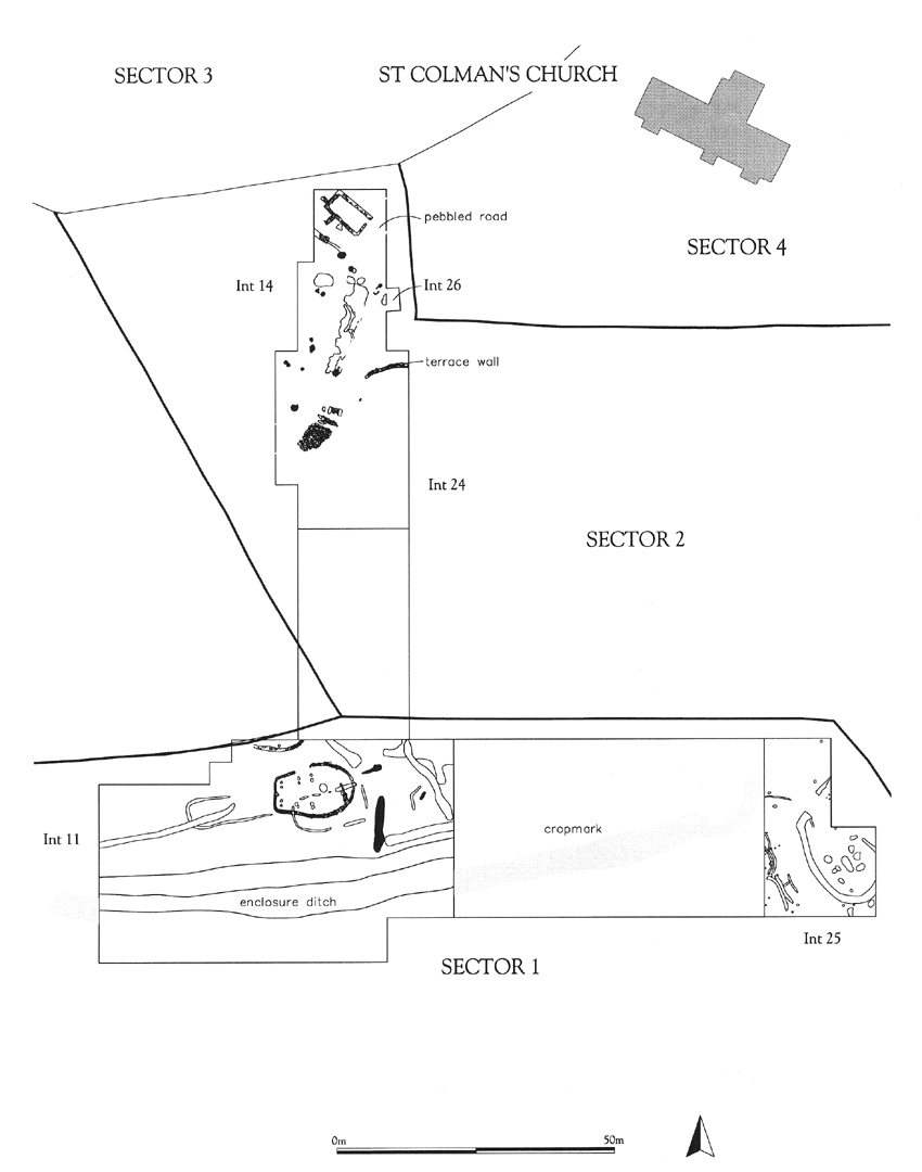
There were two operations in 1998: in the northern half of sector 2 (Int 14, 24) and at the eastern end of Sector 1 (Int 25) (Fig 2).
Click drawing view a larger image.
Figure 2:The excavation sectors at Portmahomack, showing principal features to 1998
Sector 1
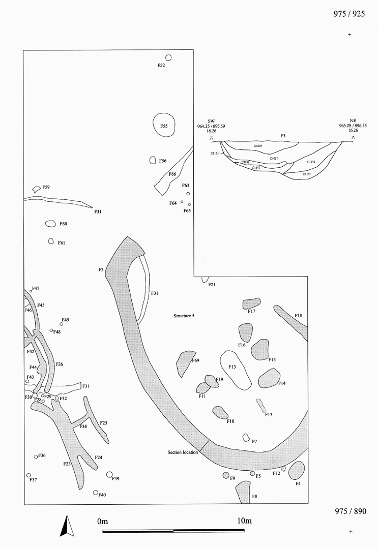
Following evaluation in 1996 (Int 11), the detailed mapping of Sector 1 had commenced at its eastern end, a task largely carried out by the participants in our Field School (Int 25). Sixteen modules (units of recording), each 4x8 metres, were examined , of which four had already been opened, mapped and partially excavated in 1997 (Fig 3). Contexts and features were defined and recorded by the strip-and-map technique (Bull 1, 34). Structure 5 was an oval enclosure ditch (F3) apparently open at one end and about 15m along its long axis. It enclosed an oval central pit, F13, which was surrounded by six or more round pits which may have held posts or upright stones. The filling of the enclosure ditch showed an initial slumping from the inner side, suggesting a mound of earth over the interior. The central pit, unfortunately cut through by two field drains, contained a charcoal-rich soil which has been sampled for analysis. There was no obvious trace of cremated bone, and no dateable material in association with Structure 5, which is still unidentified and may be for funerary purposes or habitation. To the south-west of Structure 5 lay a small group of shallow gullies and post-holes which may have belonged to a sequence of structures of some kind. F31 was a shallow gully which also seemed to define a curvilinear enclosure. It was stratigraphically earlier than the Structure 5 enclosure ditch (F3).
Click drawing view a larger image.
Figure 3: Excavations on Sector 1, Intervention 25. Plan of principal features at the west end
Definition of these features, which are generally truncated and poorly preserved, will be continued in 1999, and placed in the context of a larger area. At present they suggest that undated habitations, possibly prehistoric, do lie outside the main enclosure ditch which defines the Tarbat site (the shaded feature in Fig 2; see Bull 2, 7-9). They may prove to be associated with the ard marks left by a regime of prehistoric cultivation pre-dating the enclosure. This cultivation is provisionally assigned to the Iron Age or before.
Sector 2
The excavation of the northern end of sector 2 (Int 14), which lies within the Glebe Field and is destined to be the site of the Tarbat Discovery Centre car-park, was begun in 1996 (Bull 2, 9-11). It was extended southwards for 30m in 1997 (Int 24) and again re-opened by mechanical excavator without damage in 1998. The ground slopes down southwards and westwards from the road and the churchyard wall, and the stratified deposit beneath the surface thickens from 300-400mm at the northern end to a depth of 1 metre or more in waterlogged ground towards the south. The ploughing of this slope over the years has resulted in the truncation of features on the higher ground and the burial of features in the lower lying parts. Because of this, the final phases represented in this deposit are of different dates depending on their position on the slope. The lower, southern half of the site(Int 24) retained features of the later middle ages, whilst in the higher, northern half (Int 14) features of an earlier date, perhaps 9th century or before, were already exposed. The later features include a pebbled track, metal-working hearths and pits belonging to agricultural and light industrial activities (Bull 2, 9-11; Bull 3, 3) and provisionally dated by pottery to the 12-15th century (see reports by Derek Hall and Cecily Spall). Numerous patches of charcoal, ash and buff sand may belong to light industrial waste, but the presence of square hearths lined with stone slabs, suggest the presence of timber buildings, the foundations of which have yet to be defined.
Click drawing view a larger image.
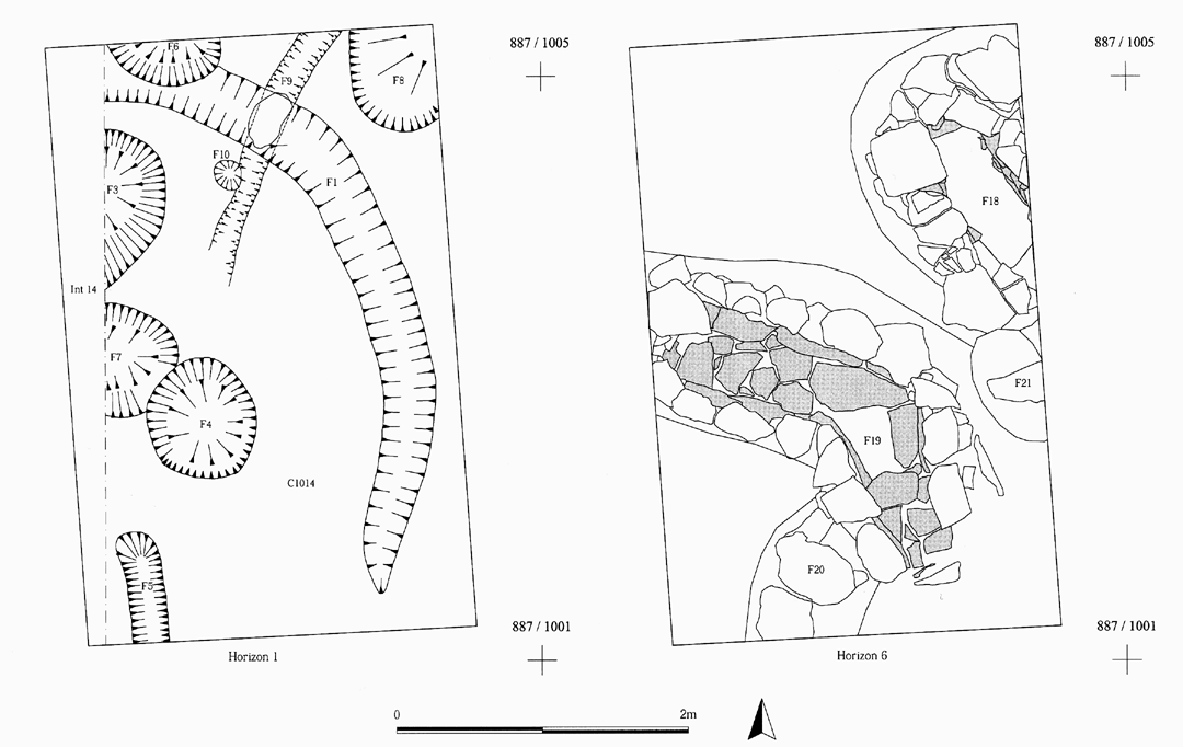
Figure 4: Excavations in advance of an oil tank (Sector 2, Intervention 26) Plan of horizons 1 and 6
A test-pit excavated in the early part of the season (Int 26, Fig 2)offered confirmation of the general deposit-model and gave considerable assistance in determining the stratified order of the deposit over Sector 2 generally. The test-pit had to be dug to accommodate an oil storage tank to supply the central heating system in the Tarbat Discovery Centre, which was concurrently under construction. An area 4 x 2.6m between Int 14 and the churchyard wall was excavated archaeologically to a depth of 1.5m. The deposit that was removed averaged a depth of 1m and featured a sequence of complexity and promise. At the highest levels (Fig 4, Horizon 1) were pits and gullies which can be associated with the medieval industrial phase contacted over Int 24 as a whole. At the lowest level (Fig 4, Horizon 6), was a number of robustly constructed stone foundations or culverts, reminiscent of those showing (although in a truncated form) in the northern part of Int 14. Between these two levels are deposits of some variety indicating that many episodes took place, prominent among them a layer containing much charcoal and evidence of fire (running into F14 in Fig 5).
Click drawing view a larger image.
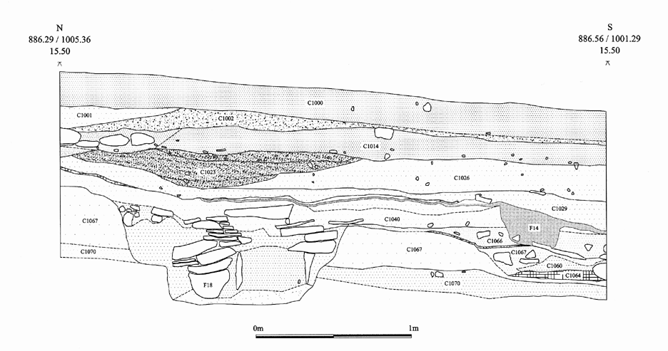
Figure 5: Excavations in advance of an oil tank (Sector 2, intervention 26), Section.
When the pebbled track (or road, fig 2) was removed by excavation in 1998 it was found to have covered a hollow way, where earlier layers had been worn through, presumably by cattle or other stock. Included in the sequence so exposed was a charcoal-rich layer, in which fragments of sculpture (TR36-38) and an eighth-century coin were found (see Mark Blackburn's report, below). This suggests that a major burning episode beneath the medieval village seals an earlier settlement with robust stone buildings, which are currently expected to be dated to the 9th century or before.
The excavation of the Glebe Field sequence is a great challenge technically, since the stratigraphic visibility is very variable. The determining of the edge of layers, their order and their equivalence is therefore a continuous problem needing systematic horizon mapping, section cutting and detailed dissection. The excavation is currently anticipated to continue until 2000 or 2001.
NEXT: New Finds of Sculpture
BACK: Introduction
Last updated 10 October, 2003.
Contact the Tarbat Discovery Programme


© 2003-2006 University of York
![]()
![]()
![]()