SICILY in TRANSITION AD 600-1200
Overview
The departments of archaeology at York and Rome 2 (Tor Vergata) began a joint research project in 2014 investigating the Byzantine-Arabic-Norman transition in Sicily, with special focus on changes in social structure, agriculture and trade. Survey and excavation in three or four parts of the island are intended to reveal sequences of settlement and burial; the metal finds, pottery and botany are to be studied in Italy and the human bone, animal bone and contents of amphorae in York.
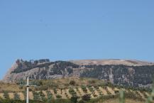
The focus of research in 2014 was CASTRONOVO DI SICILIA, a town in central Sicily, where the two main sites investigated were MONTE KASSAR, a short-lived Byzantine stronghold constructed at1030m AOD (7th/8th century AD), and CASALE SAN PIETRO an extensive occupation area of the 7th–13th century on the flood plain of the River Platani, occupying either side of the main Agrigento–Palermo road.
The project is directed by Alessandra Molinari (Rome) and Martin Carver (York) with the support of Stefano Vassallo of the Soprintendenza per i Beni Culturali e Ambientali di Palermo.
The team was courteously hosted by the Mayor and town of Castronovo.
- For results of the 2014 and 2015 seasons, please see the "Activities" tab
Activities
The 2015 Season at Castronovo
INVESTIGATIONS at CASTRONOVO di SICILIA
Second season of Evaluation, Results and Prospects, 2015
Co-directors:
Martin Carver, Department of Archaeology, University of York
email: martin.carver@york.ac.uk
Alessandra Molinari, University of Rome 2 (Tor Vergata)
email: molinari@lettere.uniroma2.it

Introduction
The period of history being studied by the present researchers is the 6th to 12th century AD, and the subject of interest is the social and economic change brought about by successive changes in regime in Sicily (FIG 1). Europe during the period concerned was subject to a wide range of ideological confrontations: Christian factions drove the Carolingian empire in the north (8/9th century) and the Byzantine empire (6/12th century) in the east. Islamic empires were established by the Umayyads in the 8th century, the Abbasids in the 9th and the Fatimids in the 10th. Sicily lies at the centre of this zone of confrontation, with the western part of the island being the more subject to Arab influence and the eastern largely remaining aligned with Byzantine Greece (FIG 2).
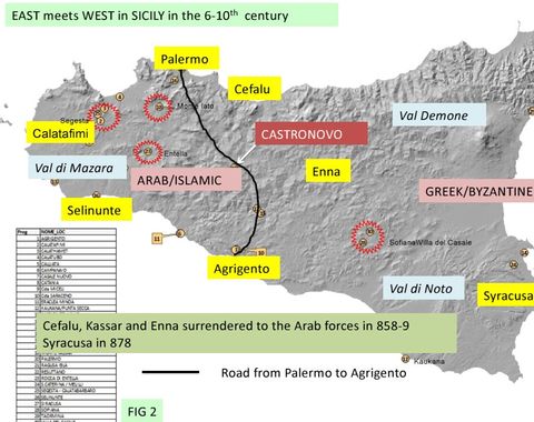
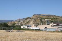
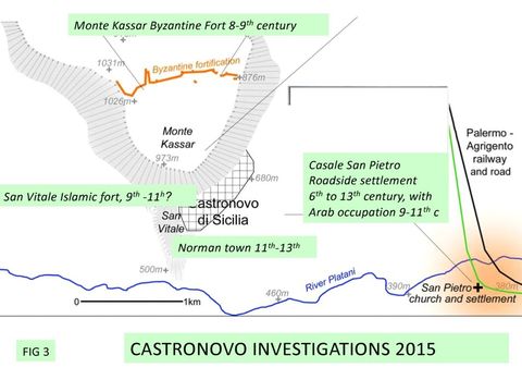
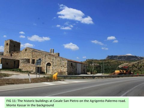
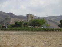
Castronovo di Sicilia lies in the centre of the island at the headwaters of the Platani and Torto rivers that flow respectively south and north, and halfway along the line of the current road and railway that connects Agrigento and Palermo. Three principal areas of archaeological interest have been defined: at Monte Kassar (1050m) are the remains of a late Byzantine defensive system dated to the 8/9th century; at San Vitale are the ruins of a later stronghold created by Arabs in the 9th century, in which most surviving monuments are Norman (11/12th century); and in the plain beside the River Platani at Casale San Pietro is an extensive Byzantine settlement of the 5th to 7th century, and a 9-11th century Arab settlement focused on the historic building at San Pietro itself (FIG 3).
Investigations in 2014
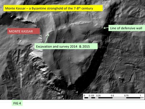
These centres were defined by background research and endorsed by the 2014 and 2015 evaluation seasons. In 2014 at Monte Kassar, a series of buildings was located on the summit of Monte Kassar by magnetometry and a drystone house built on the inside of the defensive 2 wall was excavated on the south side of a point previously investigated by Agata Villa (FIG 4).
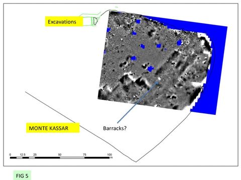
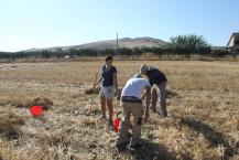
This was the first certain indication that the Byzantine fortress was occupied (FIG 5, 6, 7). In the same year the area on the plain to the west of San Pietro was surveyed by surface collection and magnetometry, the results of which suggested a dense occupation from the 5th to the 13th century. However test excavation showed that this area had been subject to deep destruction and dispersal of materials due to ploughing. All three major centres were further defined in 2015.
Investigations in 2015
Monte Kassar, 8th-9th century Byzantine fortress
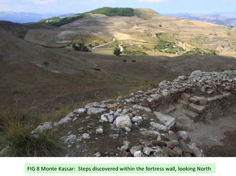
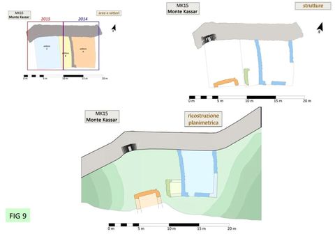
On Monte Kassar, the area examined lay on the north side of Agata Villa’s excavations. It proved to be an open yard created by levelling prior to the construction of the defensive wall. Standing on this yard were drystone walls of two buildings. These had few diagnostic features, but are thought to be closely associated with the defensive wall, both in time and purpose. At this point, a three-way set of steps had been incorporated in the body of the wall, and a layer of tread leading to them suggested intensive use over a considerable period (FIG 8, 9).
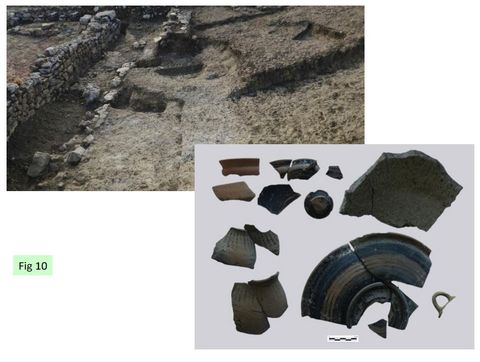
The previous excavations by Agata Villa had contacted a spread of plaster thought to have underlaid the Byzantine features. The plaster was encountered on the west side of a rudimentary wall assigned a date in the Archaic period. Exploration of this plaster floor over a more extensive area showed that it had been laid in a semi-circular hollow cut through the blocky sandstone natural. There was no wall associated with this semi-circular cut, but a shallow scoop was located in the centre of the plaster spread containing a rich assemblage of archaic pottery and lumps of pure lime. This may have been intended as a hearth but there were few signs of burning. The surface of the blocky sandstone natural further west had been cut by two other features that cut each other. They were curved and narrow and the example to the north was sectioned to natural rock and proved to have thick-walled Archaic pottery in its upper fill. These features elongated resembled storage pits (souterrains) known in later Celtic cultures (FIG 10).
Casale San Pietro: Byzantine period, 5-7th century
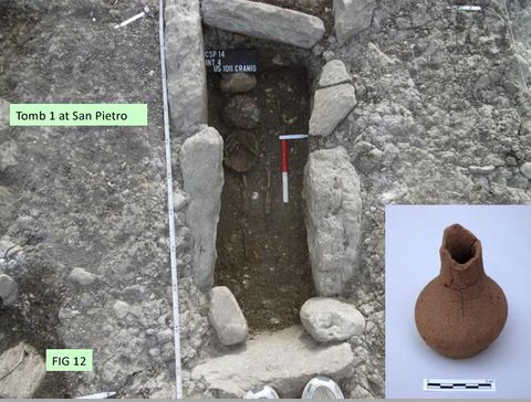
The zone indicated by surface finds as belonging to the Byzantine village was explored in 2014 when two 6/7th child burials and an 11th century hearth were excavated (FIG 12). These 3 were cut into or situated just above the natural concreted gravel of the flood plain. In 2015 two additional test excavations were carried out to the south of the church. In the area most distant from the church (Int 8) recent ploughsoil lay on natural gravel 0.4m from the surface. The area nearest the church (Int 6) contained a wall built of well mortared lozenge-shaped river cobbles, sealed by a spread of tiles and rubble at a the base of the recent ploughsoil (FIG 13).
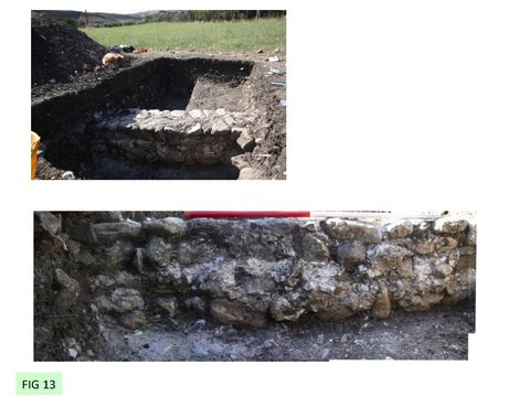
Pottery associated with the wall suggested occupation between the 5th and 7th century (FIG 14). Examination of areas of mortar extruding from the wall showed that its elevation, which stood to 0.53m, mainly comprised foundations set in mortar laid in a U-shaped trench (al sacco). The plough had therefore removed all traces of floors or exterior surfaces of activity and truncated the wall to its foundations. A row of stones displaced from the wall remained in formation. It can be noted that not only is the ploughing very deep (at least 0.4 m from present ground level) but powerful enough to displace whole courses of mortared wall sideways. The modern ploughs drawn by caterpillar tractors are quite capable of doing this, suggesting that the most destructive levelling took place recently.
Casale San Pietro: the Arab period, 9-11th century
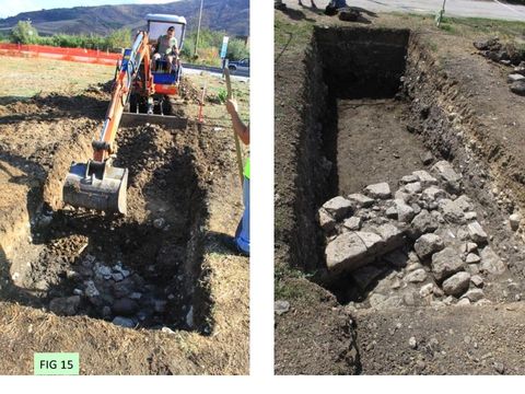
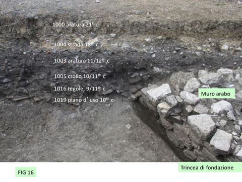
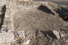
Intervention 5 at Casale San Pietro was situated west of the church building at a place designed to pick up the deepest sequence that was extant. It began as a 2x2 test excavation which cut through a metalled trackway and a ploughsoil of medieval date onto a layer of rubble that featured large sherds of 11/12th century pottery. Following this promising start, the trench was extended to a length of 6m in a northerly direction. The layer of rubble remained strong and at the north end was found by excavation to have concealed a fine wall built in ashlar, later modified by another coarser wall inserted at an imprecise right angle (FIG 15).
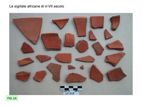
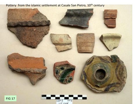
The wall therefore had two phases. The original wall had been constructed in a foundation trench. The contexts were well stratified and rich in ceramics suggesting a coherent sequence of sealed assemblages from the 9th to the 12th century (FIG 16, 17). Beneath the occupation zone of the wall lie the tiles of the 5-7th century Byzantine village. The 8th century was missing.
This is the first certain sighting of a well-stratified sequence with culturally Islamic pottery of the 9-11th century in Sicily. The evaluation indicated that survival was potentially very good: the building that was contacted survived to a height of 0.65m above its contemporary ground level. The top of this surviving structure was encountered 0.5m below the present surface of the ground, and 1.80m below the present church floor. Other walls showing in the neighbourhood of the Casale buildings or embedded in its fabric could also be survivors from 4 the Arab phase. It can be surmised that about 2.5m of stratified deposits from the middle ages (9th to 13th century) survive under the church floor in the Casale San Pietro mound.
Synthesis and future
At Monte Kassar we have obtained new information on the use of the fortress and its date. There is little doubt that it represents a serious investment by the Byzantine state to defend the island at a key point in the road network during the 8th century, and that this defence became ineffective in the 9th century. These dates, dependent largely on ceramics, are consistent with the archaeological evidence for military quarters occupied by a resident garrison in the 8th century, and the eventual surrender of the site in the mid 9th century as implied by the written documents. The interior of Monte Kassar has produced little surface material, so that the garrison appears to be largely quartered near the wall, occupied in a watching role especially to north, east and west. Topographic survey suggests that a number of other towers remain to be discovered especially in the area of the northern approaches. Further exploration can be conducted by magnetometry, which is known to work well. But the future of this site lies not so much in more research as in its development as one of the most important and most neglected monuments in Sicily. A priority would be the commissioning of a conservation and display plan.
The investigations at Casale San Pietro show that in the fields and orchards the destruction of the Byzantine and later occupation has been very thorough and virtually nothing remains above its contemporary ground level. However, negative features, such as furnaces, kilns and stone foundations give strong signals to magnetometry; much of the area of occupation could be mapped by this means, even if dating evidence could remain elusive.
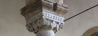
By contrast, the area within and round the Casale San Pietro historic building cluster is rich and deep and far from destroyed. This area not only has the potential to reveal the architecture and economy of Islamic Sicily, but is probably the only place where the Byzantine ‘agri-town’ has not been destroyed by ploughing. For these reasons, a programme of research, conservation and public reception is highly desirable. The area still free of buildings is large enough to answer the bulk of the research questions asked today. On the other hand the dumping of large amounts of Byzantine or earlier building stone, observed by the directors at first hand, including fragments of a large column, shows that the land is under continual pressure from farming, road-widening and redevelopment. 5 We now have a continuous ceramic type-series from the 5th century to the 13th and are ready to draw a complete narrative from Castronovo di Sicilia as it experienced successive Byzantine, Arab and Norman regimes. Since the focus of settlement shifted, the investigation will continue to be applied at the three main sites at Castronovo. At the same time we are examining the assemblages from 14 other unpublished distributed over the Sicilian island, so will eventually be in a position to report on the experience of the island as a whole and its changing contact zone.
Martin Carver and Alessandra Molinari
23 Sep 2015

LIST of Illustrations
FIG 1: Poster for the end of season talk at Casale San Pietro
FIG 2: Regime change in Sicily, 6th to 11th century
FIG 3: Four centres of activity at Castrronovo: Byzantine fort at Monte Kassar (7/8th century); Arabic citadel (9/11th century); roadside settlement at Casale San Pietro (5th to 13th century), including newly discovered Arab settlement 9-11th century; Norman and Medieval town (at site of present town)
FIG 4: DTM of Monte Kassar showing area of excavation and survey 2014 and 2015
FIG 5: Monte Kassar: Geophysical survey by Helen Goodchild, University of York, showing possible barrack blocks
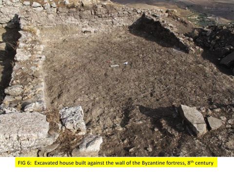
FIG 6: Monte Kassar: Excavated house against the inside of the fortress wall, 8th century
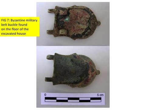
FIG 7: Monte Kassar: Byzantine military belt buckle, refurbished, found on the floor of the house
FIG 8: Monte Kassar: Steps discovered within the fortress wall, looking North
FIG 9: Monte Kassar: digital plan of Byzantine buildings against the fortress wall
FIG 10: Monte Kassar: under the Byzantine fort were traces of a settlement of the Archaic period (c500BC) with an assemblage of fine wares. FIG 11: The historic building cluster around the church at Casale San Pietro on the Agrigento-Palermo road with Monte Kassar in the background
FIG 12: Casale San Pietro: excavations in the fields beside the road reveal two children’s tombs of the 6/7th century. This example included a pottery bottle with incised cross.
FIG 13: Casale San Pietro. The fields around the church were severely disturbed by ploughing, truncating the stone buildings. This wall of a Byzantine (6/7th century) building was reduced to its foundations.
FIG 14: Casale San Pietro. Excavation of an Arab structure east of the church. Within the inner angle of the wall is a stone bench.
FIG 15: Casale San Pietro. The sequence above the Arab building, 9th to 21st century
FIG 16: Casale San Pietro. African Red slip of the 5th to 7th century
FIG 17: Casale San Pietro. Islamic pottery of the 9-11th century
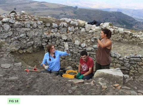
FIG 18: Staff and students from the Universities of York and Rome Tor Vergata at Monte Kassar
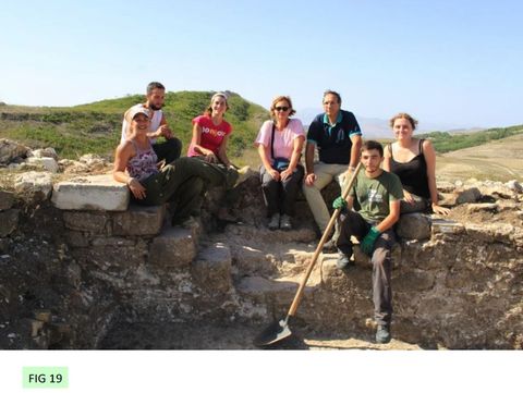
FIG 19: On the steps at Mont Kassar; staff and students of Rome and York with director Alessandra Molinari and inspector of the Palermo Soprintendenza Stefano Vassalo.
FIG 20: Madeleine Hummler, Jasmine and Fiona with Conker.
To download a PDF of the report, click here: Castronovo report 2015 (PDF ![]() , 4,664kb)
, 4,664kb)
The 2014 Season at Castronovo
The aim of the project is to describe and interpret the social and agronomic changes that occurred in Sicily between the Byzantine, Islamic and Norman periods (7th–13th century).
The purpose of the 2014 season was to explore and evaluate the area of Castronovo in central Sicily.
Eleven separate interventions were undertaken, and the following gave strong results:
On the Byzantine stronghold of MONTE KASSAR (MK)
- The defensive wall, 3m wide and 1.9m long, protecting the accessible side (north) was surveyed (Int 7)
- The East Gate was re-opened and the area inside the stronghold tested (Int 5)
- An area in Kassar Alto 8 x 12m at the high (west) end of the wall was opened and excavated (Int 6). Two adjacent houses had been built up against the defensive wall. The more easterly (Structure 1) was fully excavated. It was constructed with clay-bonded rubble walls and roofed with tiles. A Byzantine buckle, a green and a blue bead from a necklace, an iron square plaque, a folded bronze sheet, two nails and a number of sherds of pottery deriving from amphorae and possibly cooking pots lay on the beaten earth floor. These objects are assigned to the 7th–9th century AD. The house was destroyed by the demolition of the defensive wall, large blocks falling through its roof. The more westerly building, originally located in excavations of the Soprintendenza in 1984 was of similar construction, but with a plaster floor. It is planned to investigate this building and its western neighbour fully in 2015.
- A magnetometer survey in Kassar Alto mapped a number of parallel anomalies 30m long likely to represent barrack blocks (Int 8).
At the site of SAN PIETRO (SP)
An area of approximately 1 hectare was investigated to the north of the church of San Pietro.
- A magnetometer survey (Int 1) over the whole area gave a rich harvest of anomalies anticipated to include houses, kilns and streets
- Systematic surface collection (Int 2) was completed over 7000 sq m (70%) of the available area, yielding a pattern of slag, pottery and tiles dating from the 7th to the 13th century and a coin of the 7th century.
- A test pit measuring 4 x 8m (Int 4) aimed at inspecting the stratification was placed on the north-east side of the field (respecting the convenience of the farmer). An ancient course of the river Platani was located, above which lay a shallow pit containing a coin of the 3rd century AD; two children’s stone-lined graves of the 6th 7th century, containing a pottery bottle marked with a cross and a glass vessel; and a hearth closed by a small amphora of the 12th century.
CONCLUSION
Thanks to an energetic and ingenious team, the sites addressed in this first season of evaluation matched or exceeded expectations. Monte Kassar offers a major opportunity to study a late Byzantine garrison, its fate and subsequent reoccupation. San Pietro has a sequence that includes the whole period addressed by the project’s research aims.
Further work should be fruitful and lead to the redefinition of the Early Middle Ages in central Sicily, and the approach closely matches our aim of observing and explaining a time of pivotal agronomic change.
The season ran from 1–30 September 2014 and the team was hosted by the Convento dei Frati Cappuccini at Castronovo. We are grateful to the reverend Sisters, the Suore della Congregazione delle Piccole Sorelline dell’Annunciazione for their welcome, to the sindaco of Castronovo, Francesco Onorato, and to the assessore for sport, tourism and culture, Giorgio Piazza. We are especially grateful to the landowners, Signori Mastrangelo and Magaliotti for granting access. Finally, many thanks to the inspector for archaeology of the Province of Palermo, Stefano Vassallo, for his unstinting support to the project.
The report can be downloaded here:
Participants
Rome
- Prof Alessandra Molinari, University of Rome 2 (Tor Vergata), co-director, expert on early medieval Sicily
- Dr Stefano Vassallo, Sezione per i Beni Culturali e Ambientali di Palermo, heritage manager, expert on Sicilian archaeology
- Nicoletta Giannini, structural researcher
- Paola Orecchioni, excavation supervisor
- Dr Claudio Mangiaracina (CNRS Aix-en-Provence), pottery researcher
- Georgio Rascaglia, surface collection supervisor
- Excavators: Emanuela D’ignazio, Francesca Colangeli, Marco Bianchi, Gabiele xxxxx
York
- Martin Carver, University of York – co-director
- Dr Madeleine Hummler, University of York- field training supervisor
- Dr Helen Goodchild, University of York - surveyor
- Excavators: Geneviève Carver, Michelle Alexander, Jasmine Lundy, Alexandra Drosinaki, Ben Haines, Dan Miller, Veronica Aniceti, Louis Carver
Sponsors
The 2014 project was supported by:
- Università di Roma 2 (Tor Vergata), Dipartimento di Scienze storiche, filosofico-sociali, dei beni culturali e del territorio; Ministero dell'Università e della ricerca scientifica, Fondi PRIN
- University of York, Department of Archaeology, Research priming fund
- Society for Medieval Archaeology, travel grant
Advisory Group
Advisory Group
- Professor Eduardo Manzano, Istituto de Historia, Centro de Ciencias Humanas y Sociales, Madrid – Islamic Spain
- Professor Annliese Nef - Université de Paris I Panthéon-Sorbonne - Islamic Sicily
- Dr Vivien Prigent - CNRS – Paris - Byzantine Sicily
- Professor Chris Wickham - University of Oxford - Early medieval Italy