 Bulletin 7, 2001-2
Excavations at Portmahomack 2001-2
Martin Carver, Madeleine Hummler, Cecily Spall
Investigations undertaken
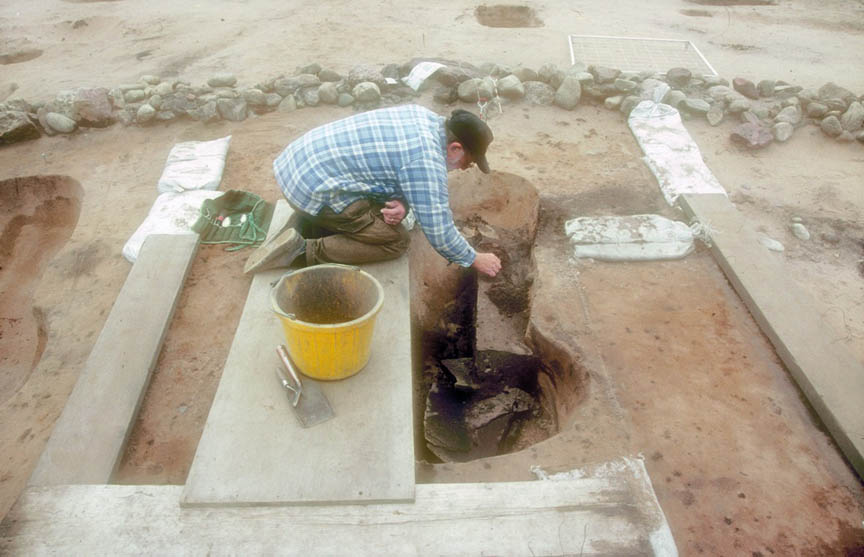
The excavations in 2001 and 2002 were small-scale holding operations designed to keep the campaign going after the completion of the Stage 2 programme while a new funding package was put in place for Stage 3. They were supported by the Tarbat Historic Trust and the National Museums of Scotland, and the main objective was to complete the study of Sector 1.
Horizon mapping had been completed over the whole of Sector 1 in 2000. This had indicated four principal areas for further study: the enclosure ditches, a possible entrance to the SE, the group of buildings S1-3 and 6, and an activity area which included a corn-drier F36, and a zone rich in debris from craft-working.
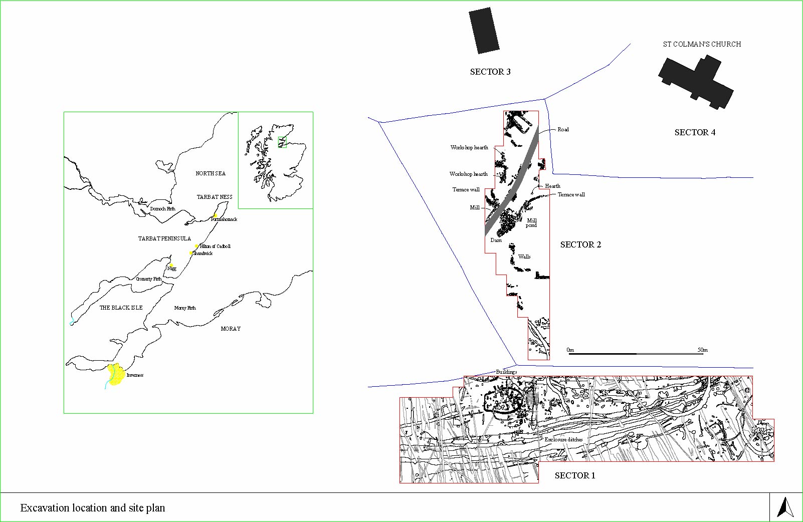
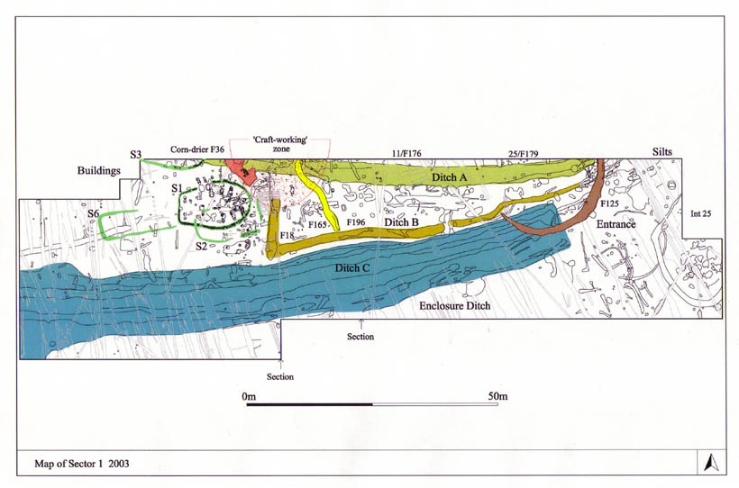
Click to view larger images of the location map and Sector 1, 2003.
In 2001, excavations were directed by Justin Garner-Lahire on an area 40x24m centred on S1, and the “craft-zone” to the east was investigated by Madeleine Hummler. In 2002. the continued excavation of S1 and the craft zone was directed by Cecily Spall, and of the possible enclosure entrance by Madeleine Hummler. A small area of Sector 2, 378m2 was re-opened in the workshop area in 2001, in order to complete some recording. The team was assisted by a University of York Field school in both seasons.
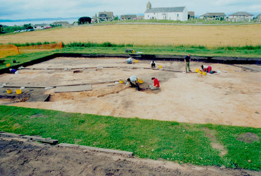
Click to view larger image of students at work.
Results
Buildings
S1 is a large structure with a bag-shaped ground plan, with a round end to the east and a square end to the west.
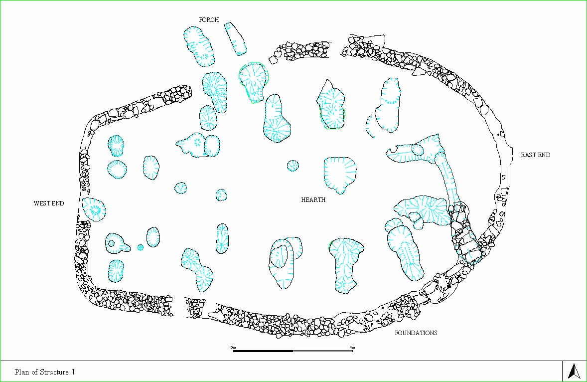
Click to view larger image of structure one.
A foundation trench filled with cobbles encloses an area 10x14.5m, and the semi-circular E end has a radius 5m with a hearth (F65) at its centre. Eight double posts carry a superstructure around the hearth. Each is an upright post on a padstone, with packing stones supported by an outer bracing post.
Click to view larger image of posthole.
The padstones were cut from a single block of sandstone. A stone lined channel (F11/67, 79) which enters through the wall on the SE side is likely to have been an air-duct or flue. At the west (square) end is a symmetrical arrangement of clustered posts. The building was entered by a porch on the north side, formed from pairs of double-posts. Four contexts within the structure, including the hearth, contained hammerscale and another three had iron objects. A rotary quernstone was included in the stones capping the flue. The hearth also contained a mass of burnt animal bone, which may have been used as fuel.
The attributes of the building recall the “kiln-barn” long known from the country west and north of the Highland line (Fenton 1999,100), although the absence of a circular stone kiln and the presence of the small shallow hearth and flue, as well as the double posts suggests that, in this case, the grain was laid on an upper floor. The presence of hammer-scale invites an alternative interpretation as a smithy, or dual use as a smithy in summer and a kiln barn in winter as in Sweden (Frans Herschend, pers.comm.).
S3 is apparently similar to S1. It is mostly outside the excavation area and overlies Enclosure Ditch A. S2 is made up of intermittent slots or gullies marking an area 13.8m long and 7m wide. S6 is a similar structure marking out an area 14m long and 5m wide. Neither S2 nor S6 were convincing as the remains of buildings and may have been later agricultural enclosures.
Corn-drier (F36)
This feature, which is not yet completely excavated, lies adjacent to S1 and consists of a channel leading to a circular cavity with stone-built blocking between them. It was originally thought to be souterrain (Bull. 1, 35), but the components seen so far suggest a corn-drier of a sort known to have been used into recent times. These were circular and stone-lined with a drying surface of straw on timber slats up to 8ft (2.4m) in diameter holding about 4 sacks of oats spread to a depth of 3 ins (80mm) (Fenton 1999, 101). Heat was provided by a peat fire carried in a horizontal flue. F36 is expected to be a structure of this kind.
Enclosure ditches
The enclosure ditches form a sequence, here provisionally designated A-C (see Map of Sector 1 in 2003), the inner being earlier than the outer. Ditch A (F11/176, F25/179, 213), or the “inner enclosure ditch”, was cut in two phases. The first was 2m wide and 1.4m deep, which was backfilled with its own upcast, and the second 4m wide and 1m deep, which silted up. The final fill was rich in craft-working debris, which may have formed by dumping or working in situ. Ditch B (F11/155, F25/196, F25/101) was 2m wide and 0.6m deep and backfilled with hard pink clay deriving from the lower subsoil. It is thought to be a predecessor to Ditch C or a base for its rampart. Ditch C (F11/158, F25/132) was c5.5m wide and 1.5-2m deep. It was lined with wattle and later backfilled with twigs, leaves and tree stumps. A radiocarbon date on the wattle suggest that this ditch was functioning by the 8th century, but the date of its disuse has yet to be determined.
A southeastern gateway to the enclosure was sought but not found. Ditch A turned north at its eastern end, Ditch B petered out and Ditch C butt-ended. There was no eastern continuation of Ditches B and C, but an area of silts was defined where they should have been. It seems that the enclosure ditches functioned as storm drains and that water continued to pass around them on the east side, feeding the valley stream that led to the mill pond.
Numerous attempts to improve drainage followed the backfilling of Ditch C, and probably relate to the Medieval period and later. F25/125 is a ditch crescentic in plan which cut through the backfilled Ditch C. It is thought to be a later attempt to drain standing water.
The Craft-working zone
Debris from the making of glass and non-ferrous objects, represented by large number of fragments of moulds and crucibles has been noted in the central northern area of Sector 1 since 1994. The distribution of the material is confined to an area about 24x10m lying to the east of S1 and to the north of Ditch C (see Plan of Sector 1, 2003). It overlies, and concentrates on the surface of the backfilled Ditch A, and probably continues northwards into the unexcavated part of the Glebe Field. There were fragments of crucible in corn drier F36 and mould and crucible fragments in ditches F18 and F165 (below). The features of neighbouring S1 contained debris from smithing, but little that could be attributed to non-ferrous metal-working.
An intensive search for adjacent features which could represent structures for craft-working in situ drew a blank; the candidates proved to be scoops and hollows perhaps caused by trees, shrubs or burrowing animals Within Ditch A, the rich assemblage included animal bones, slag and a whetstone and iron objects as well as mould and crucible fragments. This concentration of material and the identification of some post holes and hollows within the fill of the ditch suggested that craft working may have taken place on the surface of its disused surface. Alternatively, these and the other fragments of moulds and crucibles found in the zone may represent the dispersal of a major dump of craft-working debris which had derived from workshops further north. The area of Ditch A under excavation in 2002 was subject to grid sampling with the aim of identifying “hot spots” of activity and it is intended to use pH analysis, magnetic susceptibility, phosphate and trace element analysis in order to identify possible craft-working in situ.
Ditch F165 was 1.5m wide and 0.6m deep and followed a sinuous course to the northwest. It contained two whetstones and mould, crucible and slag fragments, probably redeposited from cutting through Ditch A. This ditch is thought to be a Medieval or later attempt to assist drainage.
Interpretation of Sector 1
Sector 1 is an area of the monastery which refers mainly to agricultural activities. Ard-marks are among the earliest features. The enclosure ditches are dedicated primarily to water management. The principal structures are currently being assigned to the drying and storage of grain, with a secondary use of kiln-barn S1 as a smithy. Other features would indicate pens for the management of stock, although their date is uncertain. A spread of crucible fragments and other debris from working glass and non-ferrous metals may represent a dump of material from the Sector 2 work-shops or a phase of later craft-working in the north-central area of Sector 1.
NEXT: Research
BACK: Summary
Last updated 10 October, 2003.
Contact the Tarbat Discovery Programme


© 2003-2006 University of York
![]()
![]()
![]()