 Bulletin
3, 1997
Bulletin
3, 1997
Tarbat Old Church
The excavation and architectural recording of St Colman's Church, sector 4: a preliminary report By Martin Carver and Annette Roe, based on research by Annette Roe, Fred Geddes and Martin Jones.
Description of the investigations, Int 18-23
Initial assessments of the archaeological potential were carried out in 1995 and 1996, proceeding from observations made by Geoffrey Stell and Jill Harden, and including trial excavation in the north aisle (Bull 1, 37-42; Bull 2, 14-17). As a result of this assessment, the whole of the interior of the church, including the foundations where exposed, were examined in 1997 under the direction of Annette Roe, and the wall fabric and roof space of the upstanding church were investigated by Martin Jones. The recording of the fabric and roof space by Fred Geddes, the architect to the project, began in 1994 and has continued throughout the repair and refurbishment of the church into 1998.
The interior of the church may be divided into three areas (Fig 3). In the nave the excavation was carried out at Level D (see Bull 1, appendix B) and encompassed the stratigraphic removal of all archaeological contexts down to the subsoil, a deposit about 1 metre deep. However, baulks 1 metre broad had to be left on the north and south sides from foundation level in order to protect the building. This excavation encountered and recorded some 150 articulated skeletons, as well as a large charnel of mixed bone in the upper strata. The earliest burials were cist graves with slabs on all sides and over the top. The foundations of the west wall of the earliest church were located and excavated, and shown to be later than several burials, including a cist grave. Fragments of early medieval carved stone were recorded in the walls at the west end (TR 14, TR 32) and a later medieval grave cover was revealed and left in situ in the north western corner of the nave.
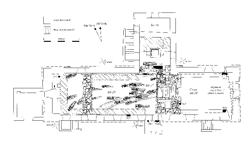
Figure 3: Plan of St Coleman's church showing areas examined, a sample of burials and the positions of early medieval sculpture located in the wall fabric.
In the north aisle, the north wall of the earlier church was located and excavated, and two fragments of early medieval sculpture (TR21 and TR22) removed from it. The space adjacent to the wall was occupied by the grave of William Mackenzie whose memorial remains in situ in the west wall of the north aisle. The centre of the north aisle was taken up by a burial vault constructed in the early 17th century. The area enclosed by the mid-18th century extension to the north aisle was excavated in 1996 as part of the aborted service trench (Int 16, Bull 2, 13).
The east end of the church interior is occupied by a crypt, the floor and fabric of which was investigated. The floor proved to have been lowered into subsoil and timbered, probably in the 17th century. No other deposits remained. The fabric included three early medieval stones (TR 20, 26 and 29) two of which (TR 20 and 29) were removed. The crypt, which cut away the chancel of an earlier church, was probably constructed in the 13th century, and a vault inserted in the 17th century to give the structure its present form. The alignment of the east wall of the crypt was felt to indicate the existence of an earlier building at the east end, but this, being part of the current grave-yard, was not available for investigation.
Preliminary analysis has allowed the identification of eight structural phases for the existing church, preceded by two phases of burials for which no contemporary church structure has been identified with certainty.
Phase 0: Cist-burials
Features preceding the earliest stone church were:
- a small group of extended inhumation burials in long cists orientated roughly NE-SW and concentrated towards the western end of the excavated area;
- a deep ditch running on approximately the same alignment as the cist-burials.
Only one cist-burial was complete, another empty, and others either heavily truncated by later graves or too close to the limits of excavation for safe investigation. These burials had been cut into a buried soil overlying the natural subsoil and appeared to respect each other. They were lined and covered with well set flat fragments of red sandstone, and contained no grave goods. The bone was in fair condition and should certainly be adequate for dating purposes.
The ditch, (maximum width 0.9m) had a maximum depth of 0.85m from the sand subsoil. There was no direct dating evidence, but the ditch had been cut into the same buried soil as the cist-burials, and may have provided a boundary for this early cemetery.
Dating: A recent review of cist-burials in the report on Hallow Hill (Proudfoot 1996, 443-444) showed that the majority can be assigned by radiocarbon dating to the period 7th-9th century AD.
Phase 1: Burials with head-settings; and an inferred early church (Fig 3)
A second phase of inhumations, covering the whole of the excavated area, contained settings of flat red sandstone fragments placed around, and sometimes over, the head, or, in a few cases, alongside the upper torso. The burials were orientated approximately ENE-WSW. Those near the pre-existing (phase 0) ditch respected its alignment and some were cut into its backfill, suggesting that it was still visible, but no longer used as a boundary. The burials were arranged in rows with very little inter-cutting, which suggests the use of markers, and the cemetery seemed to continue beyond the limit of excavation on all sides.
The earliest stone building so far identified in the area of St Colman's church may be contemporary with these burials. This building is inferred from the alignment of the east wall of the crypt, which is approximately orthogonal to the burials with head-settings. During restoration to the exterior, a fragment of walling was identified incorporated into the outer foundations of the north wall, which could represent the north-western corner of this putative building. If such a building existed, it would have been partially subterranean with respect to the old ground surface, which itself lies some 2m below the present surface of the graveyard. Given the slope of the graveyard to the east of the present church, the building may have taken the form of a projecting crypt, where the face of the east wall was exposed, but the western part of the building was cut into the slope.
It is therefore suggested that in this phase there was a partly subterranean chapel on the site of the extant east crypt, and that there was an associated cemetery of burials with stone head-settings and grave-markers. It seems likely that the many grave-marker stones, such as TR 20, 21, 22, 29, 30, 31, 33 and 34 which were re-used in the foundations of the phase 2 church, had stood originally in this cemetery.
Dating: Other head-setting burials have been excavated at Balblair (Reed 1995) and Kirkhill (Wordsworth 1981) and have produced radiocarbon dates ranging from the 8th to 11th centuries. This is consistent with the stylistic dates of the early medieval grave markers (see below) which should be 9th century or later. According to Origines Parochiales Scotiae, St. Columba was said to have built a church here in the 6th century with a vault 30 ft long. This might be a reference to the phase 1 church proposed here, the remains of which could date from any time between 6th century and the 12th. A 9th century date remains the most likely, on the basis of the association with the sculpture.
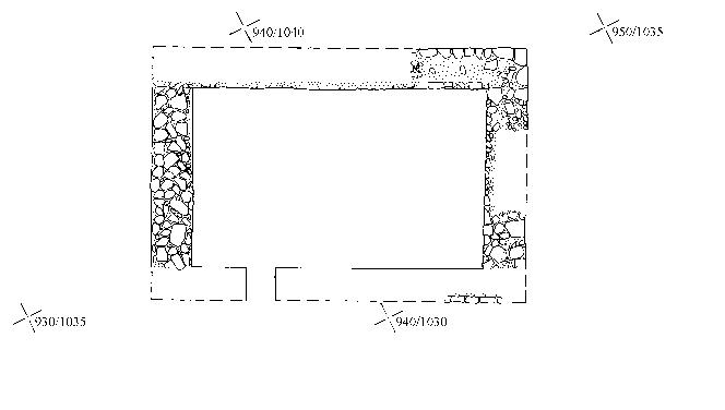
Phase 2: A rectangular chapel of the 10-12th century (Fig 4)
The earliest structure in the area of the nave took the form of a simple rectangle (c11.6m x 8m) aligned east-west with a single door on the southern wall near to the west end. Cutting a second buried soil which had formed on the surface of the phase 0-1 cemetery, it was constructed with a foundation of c.0.5m of unbonded rubble, mainly water-worn boulders from the beach, laid in a trench 1.2m wide. Above this, to a depth of approximately 400mm were laid flat sandstone slabs bonded with a lime-rich white mortar. This supported an original wall elevation of square blocks of red sandstone, with no sign of interior plaster. Incorporated in the foundations of this building were the five grave markers TR 21, 22, 30, 31 and 33. Traces of white mortar on TR 20 suggest that this stone too was broken up and used in the foundations of the phase 2 chapel. The layer of flat sandstone slabs (now supporting the present church) probably includes many more grave markers deriving from the phase 1 cemetery.
Dating: The building is later than the 9th century, the central date for the carved stones included in its construction, and earlier than the phase 3 chapel which appears to be of 12th century form. The formation of a buried soil over the phase 0 and 1 burials, might suggest an interval between the use of that cemetery and the construction of the phase 2 chapel.
Phase 3: Chapel, 12th century (?) (Fig 4)
A squared annex was added to the east end of the phase 2 building, giving the characteristic form of a medieval chapel. Its width was 5.8m, but the length remains unknown since it was cut away by the later phase 4 crypt.
Dating: The earliest churches of this kind are dated to the 12th century (MacGibbon and Ross 1896-7; Cruden 1986).
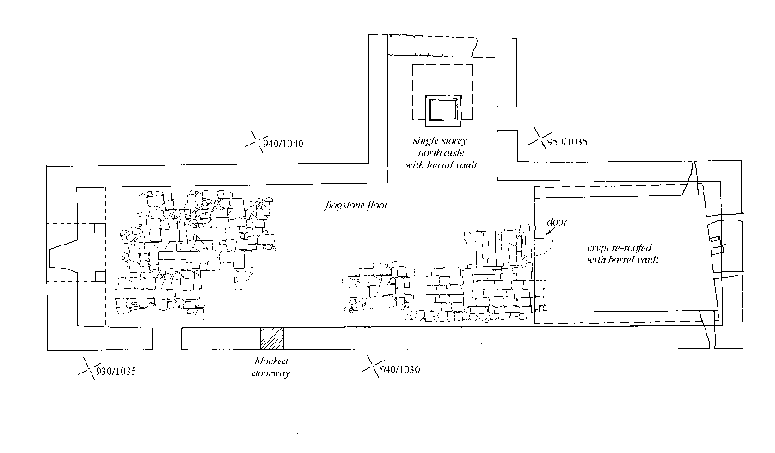
Phase 4: Church with crypt, 13th-15th century (Fig 4)
The phase 3 church was extended by 5m to the west, and by c.10m to the east, demolishing the earlier chancel. The new build was bonded with a greyish shell-tempered mortar and presented a chamfered plinth at ground level on the exterior. The entrance remained in the same position on the south wall.
Phase 3 (12th century)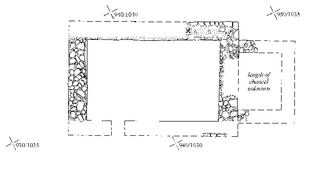
Phase 4 (13th - 14th century)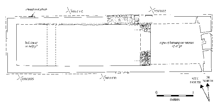 Figure 4: Plans of St Colemans Church by phase. Phases 2, 3, and 4.
The Crypt
The extension at the east end comprised a rectangular chancel, having the same width as the nave, with a crypt constructed below. The crypt incorporated the earlier (phase 1) wall as its east end. There were two narrow lights and an aumbry at the east end and two other lights positioned at the eastern end of both north and south walls. Although the original ground surface was comparatively high where recorded around the crypt entrance at the western end, it was noted during restoration work on the lights on the southern and eastern sides, that the external face of the crypt wall was dressed to a depth of at least 1m below the chamfered plinth (pers. comm. F.Geddes). This suggests that the ground surface originally sloped down rapidly eastwards leaving the east end of the crypt exposed. The entrance would probably have been at the western end in the same position as phase 5. Phase 5 renovation had also removed any evidence for flooring in this phase.
The masonry remaining from this phase, both in the crypt and the nave, all shows significant signs of burning on the interior with the red sandstone scorched to a bright orange colour indicating the event of a serious fire. A series of dumps and lenses of ash and charcoal survived in the nave near the crypt entrance, possibly associated with some of the fallen thatch roof or burnt timber floor.
At the west end the extension may have been intended to carry a tower. The truncated remains of a bell-casting pit containing fragments of fired clay mould, found in the centre of the nave, may be associated with this phase.
A similar extension may be noted at Iona and is there attributed to the 13th century (Ritchie 1997,104). The rebuilding may have been made financially possible by the assignment of Tarbat to the Abbey of Fearn, documented during the 13th century. Its destruction by fire may relate to a documented incident in the early 1480s when the Mackays of Sutherland took refuge in a vault, but were burnt by their persecutors, the Rosses. This incident, which resulted in the death of clan leader Angus Mackay, led to the battle of Alt na Charrais in 1487 (Gordon 1813).
Phase 5: The Church adapted for the Reformation (16th-17th century) (Fig 5)
Major renovations and refurbishment are attributed to the Reformation. The crypt was cleared out and cleaned to the subsoil at the level of the wall footings and a new barrel vault constructed inside the line of the 13th century crypt, but re-using the eastern and western walls. The vault was bonded with a silty clay at the sides and a coarse but hard buff mortar at the top. This mortar, a type recognisable in all the building work associated with this phase, shows the imprints of the centring used in the vault's construction. A layer (c0.10m thick) of the same silty clay as the wall bonding was laid on the floor, presumably as a form of damp-proofing, and on top of this was found a dense layer of organic material. This may have been the remains of a wooden floor although no joists or nails were encountered.
A new entrance was constructed at the western end comprising a steep stone staircase flanked by walls and leading down from the nave to a doorway with a door opening into the crypt. The design of the entrance at the level of the nave floor is not known since it was re-modelled in phase 7.
A single-storied north aisle was constructed with a doorway on the eastern wall and a small central burial vault beneath the floor. This vault was bonded in the same way as the crypt with clay silt on the side walls and mortar on the vaulted roof. Burials remain within this chamber, cut into the soil from the level of the base of the walls. (The vault has been cleared of rubbish, but the intact burials have not been excavated). The entrance was a rectangular aperture with a stone surround worked to accommodate a hatch.
A floor of sandstone slabs provided a horizon for the events of this phase. The floor was bonded to the openings for both the eastern and northern vaults. The south doorway used in the earlier church was blocked and a new doorway inserted further west.
At some time after the insertion of the floor, but still using the same type of mortar, a relieving arch was inserted inside the west wall, thus thickening it to nearly 3 metres. The purpose of this was to support a tower. However, the belfry, Tarbat Old Church's most distinctive feature and landmark seems to have been added in the next phase (see below). The relieving arch seems from the first to have been reinforced by two stone pillars which thrust directly on to the soffit.
Dating: The walls of the north aisle carry two memorial cartouches dated 1623, and a monument to William McKenzie dated 1642, which, although re-inserted in phase 7 (see below), were probably originally erected in this phase. The Reformation was at its height in this part of Scotland in 1560 (Dunbar 1996, 127-128). The developments at Tarbat Church were probably undertaken after 1623 when Sir John Mackenzie bought up most of the land in Tarbat. He and his son, George, later Lord Tarbat and then Earl of Cromarty rebuilt the church and built the stone pier. It is at this period that the old medieval village discovered in the Glebe Field (Sector 2, above) was abandoned, and the occupants no doubt moved to the east end of the beach beside the pier. The north aisle was constructed to serve the Mackenzie family, whose members were buried within it. The new internal arrangements would have focussed on a pulpit, probably set against the south wall, with the communion table in front of it (Howard 1995).
Phase 6: Rebuilt mid-18th century church (Fig 5)
This phase saw the rebuilding of the whole church from its foundations with the exception of the north aisle, west gable, western relieving arch and possibly parts of the east gable. It appears (stratigraphically) that the extant square belfry tower with its famous dome belongs to this reconstruction. Two horizontal first floor galleries were inserted (their joist holes are integral with the wall fabric). The western one was higher and larger and supported by a large number of joists, while the eastern one was supported by only two. That at the west-end was dedicated to the poor of the parish, as we know from later documentation (see phase 7 below). Two windows specifically lighting the areas beneath the galleries are also part of the main build and a similar window at the east end was inserted into part of the remaining medieval gable.
The phase 5 door in the south wall was blocked and three doors inserted at ground level at equidistant intervals. The head of the western door had a flat lintel, while that of the eastern was arched. The head of the central door has been removed by its later conversion to a window. At a slightly higher level, doors accessed by steps were inserted at each end, still on the south side, allowing access to the galleries. Evidence for exterior access to these doors has been obscured by the later phase 8 stairs.
The surviving outline of the later phase 8 plaster work indicates the prior existence of timber panelling, presumably for box pews and other seating associated with this phase.
Dating: A rebuilding programme by the heritors is documented as being under discussion in the years 1721-1762, with work in 1762 being declared to be "good and sufficient" (Fraser and Munro 1988,45). The observed changes to the fabric in phase 6 seem to be consistent with this date.
Phase 7: Late 18th century repairs and modifications (Fig 5)
A later repair and modification programme is indicated by the use of a dark red clay bonding. It included the rebuilding of the north aisle, the addition of blocking beneath the belfry arch and the remodelling of the crypt entrance.
The new north aisle was longer than the previous one and included a first floor gallery, or "laird's loft". The loft contained a fireplace at the back and access was either by a door on the western side at first floor level or by a door and internal staircase from the ground floor. Either way it was towards the back. The original walls of the north aisle were taken down and rebuilt, incorporating the cartouches mentioned in phase 5 (above).
The entrance to the east crypt was made slightly smaller at this time, and its surrounding stones, still incorporated into the flagstone floor, were worked to accommodate a wooden hatch.
The walls of the church and aisle were plastered in this phase, where not previously panelled, and the west relieving arch blocked and plastered over. The plaster on the back wall of the western gallery, against the tower, showed clear signs of a barrel-vaulted ceiling of plaster on timber, and the floor of this gallery was re-modelled (either in this or the following phase), so that it sloped down towards the nave providing a better view.
Dating: A visitation of 1780 unanimously agreed "to have the aisle belonging to Sir John Gordon and to which he has the exclusive right, fitted up in such a manner as to answer the purpose of accommodating the parishioners in attending divine service, the said Sir John Gordon having given his consent to this under condition that the thing is to be done at the joint expense of the heritors, which was also agreed to". Also recorded are resolutions to have the roof plastered, and that the west gallery, currently dedicated to the poor of the parish shall be reallocated to the use of the heritors for the price of the seats (Frazer and Munro 1988, 46-47).
The modifications of phase 7 represent a considerable change in the community. The access for the principal heritor was in a very different position to the earlier aisle as it was hidden from the view of the general congregation at the back of the loft. The greater depth of the aisle also means that there is more room at the rear in which to remain out of view, a situation perhaps encouraged by the provision of a fireplace. The existence of a fireplace obviously gives the heritor a greater degree of comfort than anyone else and introduces a "domestic" element not previously seen inside the sacred space of the church. Other heritors families presumably used the former poor loft.
Phase 6 (mid 18th century)
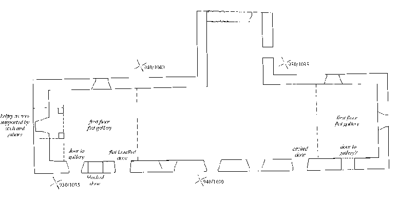
Phase 7 (late 18th century)
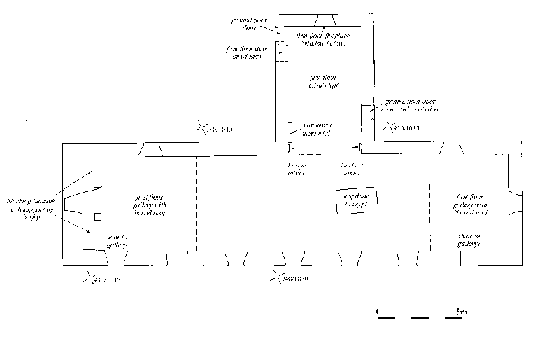
Figure 5: plans of St Coleman's church by phase. Phases 5, 6, and 7
Phase 8: Early 19th century modifications (Fig 6)
Alterations attributed to the early 19th century include the raising of the wall-plate of the whole church by 1.07m and the rebuilding of the roof with a shallower pitch. Access to the laird' s loft was moved to the front (south end) of the gallery, part of the aisle beneath the loft was partitioned off, and external masonry staircases provided access to all upstairs spaces. The sloping west gallery and the south vestry were also definitely in use by this phase, and steps had been constructed from the vestry to a raised pulpit on the south wall. All of the windows on the south side of the building were enlarged and a small window was also provided at the front of the west gallery. A window replaced the possible door at the back of the laird's loft. The Macleod (burial) enclosure was added to the west end of the church.
Other alterations to the interior involved the insertion of higher wainscotting along the walls of the church, presumably to allow for the provision of taller "horse-box type" pews. Immediately before this was done, the walls were replastered up to the level of the new raised ceiling. Above the pews, the interior was then painted a terracotta colour, the earliest surviving trace of paint inside the building. This only extended up to the height of the balcony rail at the front of the west gallery and the laird's loft. At the time of investigation, the wainscotting survived only at the west end of the west gallery where there was a door leading up to the belfry.
Dating: There is no direct or documentary date for these modifications, but they should pre-date the extensive alterations of phase 9, which should be dated after 1843.
Phase 9 (late 19th century)
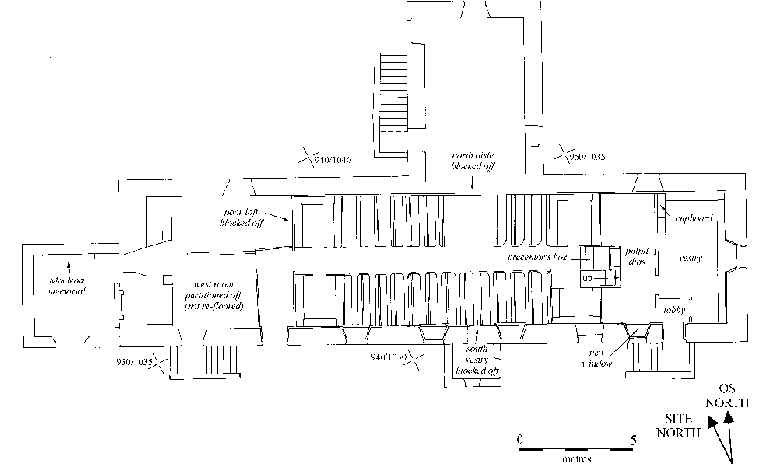
Figure 6: Plans of St Coleman's church by phase. Phases 8 and 9.
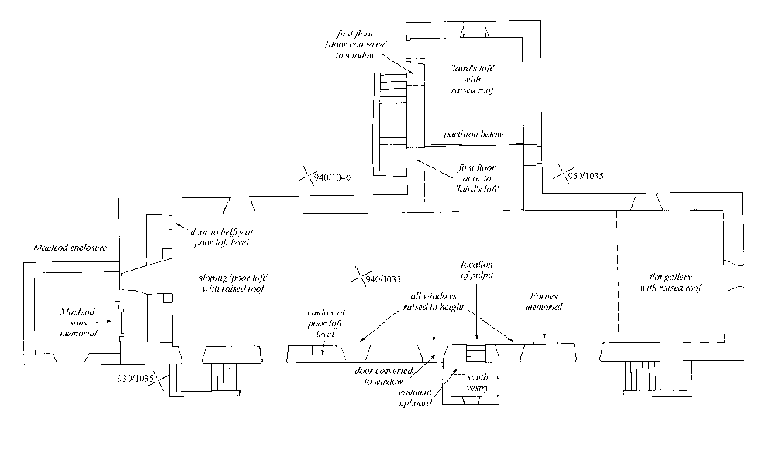
Phase 9: Modifications to the interior in the late 19th century (Fig 6)
A total remodelling of the interior decreased substantially the area available for worship. The eastern gallery was removed and a new arrangement was created by partitioning off the east and west ends with timber planking. At the east end there was a vestry with a bench running around its walls and a vestment cupboard in the north-western corner. The vestry was reached from a tiny lobby and what had been the eastern gallery access. This doorway was raised in height, to allow for the insertion of a window light above.
From the vestry, there was another door leading to a flat platform at the eastern end of the nave. This now contained the pulpit and was lit by an inserted window on its southern side. Immediately down a flight of five steps to the west was a reading desk, or precentor's box, placed centrally just one step above the level of a new timber floor in the nave. High box pews were located at either end of the nave with smaller unenclosed seating in between. The north aisle and west gallery were blocked off from the nave with timber boarding, which also covered all of the nave walls.
The most westerly door in the south wall of the nave was its main access, with the eastern door and entrance from the south vestry being blocked off. Access to the west gallery and to both levels in the north aisle was possible from their pre-existing entrances but they were now entirely separate spaces without doors or a view into the nave.
The vestry and nave walls alike were painted (or repainted) in the same colour scheme, consisting of a dark terracotta paint below separated from a larger area of pale yellow above by a horizontal black stripe. The balcony front to the preaching platform was decorated with symmetrical ecclesiastical symbols, all interior timber furnishings in the nave being stained and polished. The cupboard in the vestry was painted. Neither the west gallery nor north aisle were redecorated, although part of the western wall of the old laird's loft may have been replastered.
Dating: These alterations are consistent with the status and condition of Tarbat Old Church after the Disruption of 1843, when the Minister and the bulk of the congregation deserted the parish church and set up the Free Church of Tarbat. By 1853, the congregation of Tarbat Old Church was 85 (as opposed to 1000 for the Free Church), which may account for the more generous use of space in the old church. This was essentially the church which survived until in 1994, when Tarbat Historic Trust began its adaption of the building as a Visitor Centre.
NEXT: People
BACK: Settlements
Last updated 10 October, 2003.
Contact the Tarbat Discovery Programme


© 2003-2006 University of York
![]()
![]()
![]()