 Bulletin
2, 1996
Bulletin
2, 1996
Evaluation Results
Investigations in the south field, sector 1, 1996 (Int 11)
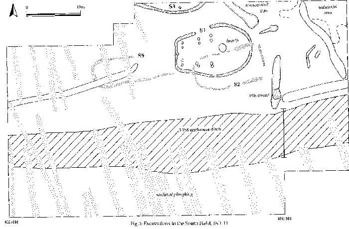
Figure 3: Excavations in the South Field, INT 11.
The southern sector had already experienced two evaluation seasons in 1994 (Int 7) and 1995 (Int 11), but a third season was considered desirable to determine the intensity of occupation in this, the extreme southern edge of the enclosure. A part of the area already mapped as Int 11 was re-opened and extended 32 metres westwards. Features already located and defined in Int 11, such as the oven or kiln, F18, and the possible souterrain, F36, were re-exposed but not excavated in 1996.
The building S1 which had attracted attention since its discovery in 1994, continued to offer surprises. In 1994, it had appeared as a semi-circle, and was predicted to a be round-house. In 1995, when mapped in Int 11, it lengthened and tapered [Bulletin 1, Fig 13] and was anticipated to be a long-house. In 1996, it transpired that the west end of this curious building lay directly beneath the baulk, and was straight. The final shape resembles a bag, purse or sporran, with six pairs of posts supporting a roof and the more open circular east end containing the hearth. The building was not excavated in the 1996 evaluation season, but considerable efforts were made to define the remains of its demolished superstructure within the ploughsoil. The part predicted to overlie the rest of the building was removed by hand at Level D (see Bulletin 1, p80), all finds being plotted to the nearest cm. Subsequently this area was subjected to micromorphological and phosphate sampling to see whether material relating to a decomposed turf or earth wall could be detected in the ploughsoil.
In the western extension of Int 11, the continuation of S3 was traced, suggesting that it will be of a similar shape to S1. A rectilinear structure, S2, had succeeded S1; another rectilinear structure, S5, was located end-on to S1, but not joined to it. There are thus now four buildings in the southern sector, all of which remain to be excavated. The other features encountered were mainly agricultural, and the depth of ploughsoil here approached 800mm. Those features cut into subsoil running N-S should belong to the runrig which generally respects the line of the enclosure and is suspected of being medieval in date. However, at the west end, the rig ran right across the backfilled enclosure ditch and confronted another series (undated) on the same alignment, with its own headland boundary ditch, laid down inside the enclosure. Also crossing the entire buried system was a drain of pebbles (F342, not on Fig. 3) laid in a trench which appeared to be connected to a series of smaller feeders bringing water into it from the fields.
Enclosure Ditch F158
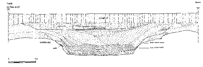
Figure 4: Section north-south through the main enclosure ditch, F158, INT 11.
At some time before these cultivation regimes had marked the landscape, the enclosure ditch, F158, had lain open and was approached on its south side by drinking cattle, which had left their hoof-prints at the ditches' edge (F262, situated at the west end, south side of the ditch). The ditch itself was sectioned along the line of the 884 easting, with the aim of inspecting its full profile, which had proved difficult to obtain in the deep wet conditions of Int 1 [Bulletin 1, fig 9].
The new section offered a relatively straightforward sequence. The ditch was 2.40m across its flat bottom, widening to about 6m at the level of the subsoil. It had been cut into boulder-clay and held water; there were preserved wooden stakes at intervals along the ditch shoulder, presumably designed to support a revetment of some kind to prevent the sandy subsoil above the clay from falling into the ditch. The surface of the clay was coloured by horizontal staining, which suggested a low-water and a high-water mark.
The waterlogged contents of the ditch consisted of a thick deposit (up to 400mm) of matted vegetation in which small twigs were a prominent component. These suggested that a hedge had stood beside the ditch on its northern side and may explain the apparent absence of a rampart at this point. This large ditch had been refilled with subsoil and topsoil components.
Some of the more puzzling aspects of the discoveries in Int 11 were resolved through an enlightening conversation with Mr George Munro of Rockfield, who remembered allotments run by the school at the west end of Int 11, and revealed that the function of the pebble-filled drain with its feeders was not to remove water, but to collect it; these were the original components of the Portmahomack water-supply, which took water off the hill behind Portmahomack and fed it into the well, Tobar 'a Bhaistidh - the sanctity of which, therefore, was not its only benison. A version of this well was recently restored adjacent to the road by Highland Council.
It would seem likely that the enclosure ditch, in spite of its early date, had performed a similar water-collecting function, as suggested by the revetment, the watermarks, and the access for drinking cattle. The siting of the ditch is indeed suitable for this role rather than as a low-lying defence. Future investigations will need to determine how the water was managed in the Pictish period (by measuring its direction of fall), and what the Medieval people did for water, once the principal collector had been back-filled.
Investigations in the Glebe Field, sector 2, 1996 (Int 14) [Fig. 5]
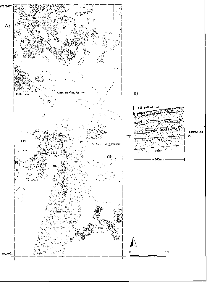
Figure 5: A) Excavations in the Glebe Field, INT 14 B) Section through the pit wall of F2 to show strata remaining in INT 14.
An area measuring 12 x 28 metres was opened at the northern end of sector 2 adjacent to the road and the churchyard wall. It is in this position that the Trust proposes to construct a car-park for visitors, and the intention was to evaluate the area and then excavate it before the Centre was opened in 1998. Following indications from an earlier evaluation trench (Int 8), the top 300mm were removed by mechanical excavator, and the surface of the archaeological deposit (Horizon 2) then defined by hand at Level B and C. Much to our surprise, the sandstone blocks of early walls were encountered at the northern end almost directly beneath the plough soil; the horizon sloped downwards to the south, so that a greater depth of ploughsoil (up to 800mm) lay over the southern side.
A map of the features exposed at horizon 2 is shown in Fig 5A. Although the aim of the operation was simply to locate and expose the strata for evaluation purposes, some of the latest pits were excavated, in order to assess the depth and character of the deposit. This proved very fruitful: the deposits, which included buried soil horizons, lay up to 400mm deep and were clearly well stratified [Fig.5B].
The underlying system showing through at the level defined was that of one or more sub-rectangular buildings with stone foundations, built beside a track. The buildings have yet to be excavated, but the best defined (S4) has a number of appended walls suggesting an annexe or lean-to shed, and patches of flagstones which may delineate a yard. The track (F18) is composed of rammed small pebbles, and seems to follow an alignment SW to NE, communicating between the fields and the axial road past the church.
This settlement area was punctuated over the years by various pits, the largest of which, F13, on the west side, contained animal bone, pottery and organic matter indicative of household rubbish. Many of the pits showed a secondary use associated with a phase of light industry, some (F2, F4) containing dished-in slag deposits, and others (F3, F11, F35) hosting later hearths for a high temperature activity such as smithing. In addition to the hearths captured in the tops of the back-filled pits, there were narrow slots which may have supported wind-breaks; these features were considered to be indications of a concentrated metal-working phase. In a final phase, deep lenses of whole shells were heaped here and there; these should derive from the extraction of food from winkles and mussels on an industrial scale. The settlement had then been succeeded by intensive ploughing which had continued up to the time of the 1996 excavation.
Dating
These pits included pottery of the 13th to the 19th century, and this may prove to be the date-range over which they were dug. Medieval assemblages were recovered from the metal-working features, which should mean that the settlement itself and the activities associated with it belong to the middle ages. Three new important residual finds suggest that the date of the earliest features still to be discovered lie in the 9th century or earlier. A fragment of metalwork [Fig 8] carries ornament that should be early medieval. A fragment of sculpture, TR23, carries the spiral motif seen on, for example, the Shandwick stone and should date to the 9-10th century. A much larger piece of early medieval sculpture was recovered from the Glebe Field excavation in 1997 (TR28), and is included here among the new sculpture reported. The provisional verdict is that the settlement sequence contacted here had begun by at least the 9th century and continued to at least the 16th.
The rich deposits encountered in the Glebe Field have further raised the expectations of the Tarbat site, which is now likely to be able to bridge the gap between the Pictish era and the Reformation. However, any hope that the excavation might be completed in time for the car-park to open in 1998 has foundered on the stones of the medieval buildings and the rich stratigraphy which lies beneath them which is almost 'urban' in character. Potentially the site of the intended car-park contains the best chance of a legible archaeological sequence across the Pictish, Norse and Medieval periods seen outside Orkney, and will be dissected with the greatest attention. Our early visitors may be obliged for a few seasons to share the car-park with this excavation.
Investigations north of the church, sector 3, 1996 (Int 15)
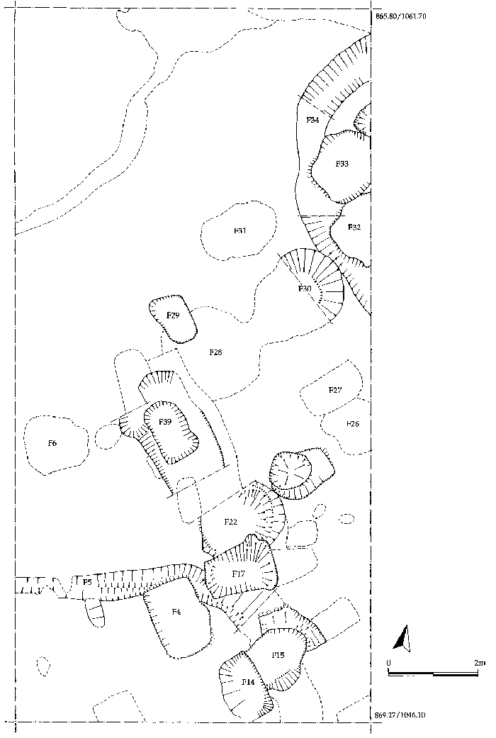
Figure 6: Excavations north of the church, INT 15.
The opportunity to investigate a site north of the church was provided through the kind permission of Mr Petty, owner of a plot of land on which he intended to build a small house. The plot was 40 x 22 metres, of which 16 x 8 metres could be used for an archaeological excavation, the remainder being occupied by a power cable, or being necessary to park spoil. The subsoil was a very soft sand resembling dunes, sloping down towards the Firth from 14.70m to 12.95m AOD, and crusted at the south (higher) end with orange iron pan. The subsoil was covered by a deep deposit of mixed sticky black soil. Three groups of features had been cut into the soil and the sand beneath it, the earliest of which included a curvilinear feature (F34) and a rectilinear feature (F5), which may have been gullies associated with structures. The second group were rectangular pits aligned NE-SW (F14,17,27,29,39), and the third, circular or oval pits (F6,15,22,26,28,30-33). The material recovered in association with these features suggested a date after the 17th century, and their function is probably connected to rubbish disposal within a garden or allotment.
Investigations at the Church, Sector 4, 1996, Int 16, 17.
Desk-top evaluation of the church site by Carver, Harden and Stell (Bull 1, 37-42), had targeted the structural sequence as the principal research objective. A second but less hopeful mission was to see whether any strata from the Pictish period had survived the scrambling of later medieval burial. Two operations were undertaken to this end in 1996: observations were made during the cutting of a service trench required by the development programme; and the north aisle and part of the nave was cleared and its floor lifted to inspect the deposits beneath.
The Service Trench, Int 16:
This trench formed part of the development programme for the church. Its intended purpose was to bring water and electricity from the mains to the church through the churchyard at a depth of about 2 metres. There were obvious difficulties with this operation, since the churchyard was still in use, and sensitivities certain to be high. The Tarbat Historic Trust and its architect, in collaboration with Highland Council and the Portmahomack Community Council had chosen a route designed to avoid all assigned lairs (burial plots); but in the event the lair plan was not an accurate reflection of what burial parties had done, and the route proved to lie across the sites of several recent interments. By a fortunate chance, relatives of one of the deceased were able to intervene before any disturbance was visited on the unmarked graves, and the trench was at once discontinued and the ground reconstituted.
In order to maximise the archaeological opportunity, the trench was excavated and recorded by the research team. The short stretch of 6m recorded outside the church contained two ancient burials, one aligned north-south, and yellow sand subsoil was contacted at 17.35m AOD, a depth of about 0.9m from the present graveyard surface.
Measures were put in place to ensure a wider notice than that provided by the Councils, and after six months consultation a new line was agreed on the south side of the church, to be dug in 1997.
Investigations inside the church, Int 17:
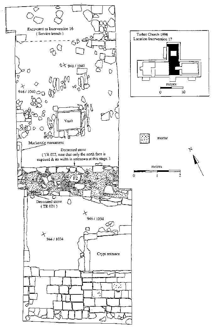
Figure 7: Excavations in the church, 1996, INT 17.
The area of the north aisle and the nave was cleared, the timber partition between them was removed, and the wooden floor of the nave was lifted over an area of about 4 x 4m adjacent to the crypt steps. Little in the way of a floor had survived in the north aisle, although a number of flat stones suggested that the area had once been flagged. Its long use as a garden shed and a park for coffin-carriers had created a rammed earth surface in which the stones of the central burial vault were beginning to wear through.
Underneath its wooden floor the nave was paved with stone flags, well preserved in places. They were most damaged in an area about 2.5 x 4m between the crypt entrance and the north aisle, and here they were lifted. After clearance of a considerable quantity of debris, including fragments of human bone, there appeared almost immediately a wall which ran across the mouth of the north aisle, F2. On the surface of this wall, just below floor level lay the incised grave-marker, TR21. The reduction of the debris on both sides of F2 exposed three courses of rubble, bonded with yellow and white mortars. Into the lowest of these courses, on the north side, was incorporated the carved stone, TR22, on which could be observed, upside down, the images in relief of a boar and a lion set in panels.
The wall F2 pre-dated the north aisle, as could be seen at its east end. But the wall itself appeared to derive from more than one period, since on its south face, the lower courses diverged from its line. The wall was therefore a survivor from the church before the north aisle was added (in about 1600), and possibly incorporated the remains of an earlier building than that. Whereas it was likely that the medieval church of St Colman underlay the present building and on a similar alignment, we were no nearer understanding the role of the crypt or its position in the sequence. The strata surrounding its upper courses were cut by innumerable burials, which continued unremittingly westwards into the nave.
At the upper levels within the nave, much of the skeletal material had been mixed and dumped, presumably by developers of the church in the 18-19th century. But it was soon apparent that below this there were many surviving articulated burials. Since burial within the church was not permitted after the Reformation, it was probable that the majority of these burials would be 16th century or earlier; they could offer an unusual opportunity to examine a northern Scottish medieval population.
There were signs that, at a lower level, some layers of stratification could be intact and readable in the vicinity of the crypt steps, but there could be no great optimism that Pictish period strata would have survived, in any legible form, the impact of later burial over the general area of the nave.
On the basis of these assessments, an excavation was planned which would examine an area 4 x 8m lying across the mouth of the crypt and the north aisle. This should place the crypt in the onstructional sequence, confirm the existence of one or more medieval churches, and contact any early strata which had survived. This programme has since been enlarged, at the behest of Tarbat Historic Trust, to include excavation of the nave and west end. The main archaeological justification for this, endorsed by Don Brothwell, was to sample the medieval population. However, it also seemed prudent to profit by an opportunity, hitherto rare in Scotland, to inspect the archaeology of a parish church on the broadest scale possible. Accordingly, a major intervention in the church was added to the project design.
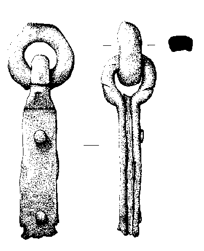
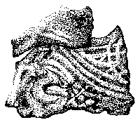
Figure 8: Early Medieval Finds from INT 14.
Discussion
The Tarbat settlement is now beginning to possess the elements of a geography. A curvilinear boundary ditch (head dyke), also functioning as a water-collector, defines an enclosure which contains the settlement. A main axial street runs E-W across the mouth of the enclosure and along the edge of the 25ft raised beach. To the north, the land fell in sand dunes towards the present beach, which afforded a prime landing-place to early travellers in the Dornoch Firth, and is now an attraction to holiday-makers. Off the street to the south are the buildings of the settlement and its church. This township endured in some form or other until the radical changes caused by the provision of Glebe Fields in the settlement area and the construction of the harbour on the rocky terrain at the east end of Portmahomack. The 18-19th century settlement continued to develop around the port with its two large girnals, and the territory in between the church and the port, even the sand dunes, has gradually been filled in with new houses in more recent times.
This dimly perceived plan bears a passing resemblance to the settlement at St Kilda, where a curvilinear ditch (the head dyke) encloses a settlement of houses ranged against a main axial street parallel to the sea. Beside or behind the houses (tigh dubh) are small drystone buildings used for storage (cleit); in front, beyond the street, are allotments for cultivation, and behind the houses, the allotments for grazing. In the allotments are found enclosures for animals (stell) and for raising cabbages and kail (planticrue) (Stell and Harman 1988).
The dating of the Portmahomack settlement implies that a planned arrangement of this kind may have begun as early as the late Iron Age (2-6th century AD) and continued until the 17th century. But the dating is at present largely circumstantial and a more precise sequence will depend on the science and fortune of the detailed excavations which are to follow.
NEXT: New Sculpture
BACK: Summary
Last updated 10 October, 2003.
Contact the Tarbat Discovery Programme


© 2003-2006 University of York
![]()
![]()
![]()