 Bulletin
2, 1996
Bulletin
2, 1996
Project Design Update
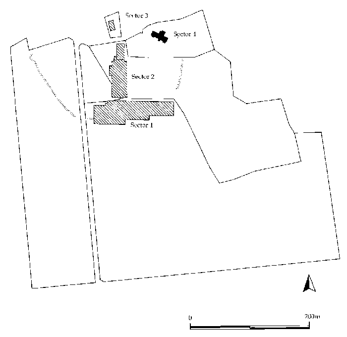
Figure 13: Revised Excavation design, 1996.
The principal aim of the research programme is to find, define, and try to understand the society, politics and economy of the northern Picts, in the context of the great formative changes of 5-8th century Europe (see Bulletin 1). The proposed method is to excavate the sequence at Tarbat, which appears to embrace the period in question, and compare it with other sites on Tarbat Ness and in the region of the Moray Firthland. However it is apparent that the Tarbat site has other periods, both earlier and later, to offer the researcher; and that these other periods (the late Iron Age and the Medieval) have much to contribute to our understanding of the Christian Picts. In practice, the definition and dating of the key cultural episodes requires the period of study to be lengthened. Although much will ultimately rely on radiocarbon dating, the depth of stratification on Int 14 (the Glebe Field site) does present an unusual opportunity to dig up an ordered sequence, several centuries in duration. Our hope and expectation is to define the material culture which signals the late Iron Age, early Medieval, Medieval and post-Medieval transitions in Easter Ross.
Accordingly, the project design has been restructured to provide a new archaeology programme effective from April 1997. This supercedes the programme published in Bulletin 1, 47-58.
PROJECT 1: INVESTIGATION AND RECORDING OF TARBAT OLD CHURCH
Rationale
The site of Tarbat Old Church is an important medieval building, and is also likely to contain evidence for the ecclesiastical centre of a probable Pictish monastery. Since the project includes the development of the church site as a Museum, the opportunity for archaeological investigation should be seized.
Interventions proposed
- Excavation of the crypt floor. Any strata remaining above the subsoil are to be recorded. There is a slight possibility that negative features (for example graves) might remain from the earliest periods.
- Excavation of the nave and part of the north aisle. Expected here are (a) a sample of medieval burials dating up to 1600 AD; and (b) elucidation of the sequence of construction for the earliest church(es), the crypt and the north aisle.
- Record of the upstanding fabric of the church, with especial attention to the sequence embodied in the west end. This will combine the work of the Royal Commission for Ancient and Historical Monuments of Scotland, of Fred Geddes (Architect) and new archaeological recording as necessary.
- Record of the trenches cut in the graveyard for building development work. At least one major trench is expected to be cut to introduce services to the church in connection with its development as a Display Centre. This will be dug and recorded archaeologically so as to profit by the opportunity to inspect the strata in the graveyard.
Timetable: the work should all be completed before the start of building, scheduled for early summer 1997.
PROJECT 2: SETTLEMENT EXCAVATION [SECTORS 1,2,3].
Fine adjustments have been made to the T-shaped transect reported in Bull 1, Fig 17 in order to improve comprehension of the medieval site discovered in the Glebe Field. The revised area is seen in Fig 16.
The sector in the Glebe Field holds at least 400mm of stratified deposit, which represent the most promising sequence yet contacted for the history of the middle ages in the region. It will need to be excavated at high precision (Level D/E) and is likely to take 2-4 full seasons.
PROJECT 3: SURVEY OF TARBAT NESS
The proposed survey of Portmahomack has been augmented to include the area of Tarbat Ness. Here the targets include sites and the environmental and agricultural sequence in all periods.
A Reconnaissance stage which includes plotting of SMR and RCAHMS information on a data-base will be followed by targeted evaluations on selected sites, for example:
- Port 'a Chait - possible harbour.
- Blar 'a Cath- battlefield placename.
- Wilkhaven - harbour.
- Bindal Muir - undated building.
- Hilton - "Roman" site.
- Bindal coast caves and landing places.
- Ballone Mill.
- Potmahomack Chapels.Balnabruach Chapel.
- Cnoc Tigh broch.
- Teampall-Earach chapel.
- Tarrel fort.
- Cadboll cropmarks.
- Cadboll Chapel.
- Hilton of Cadboll, Chapel and adjacent site.
- Balintore, burials.
- Inver, hydrology and landing places.
In parallel with the Tarbat project, a programme is being initiated which will explore the Moray Firth territory in the Early Historic period, and provide the Tarbat site with its context. This will include:
- Stage 1: Reconnaissance
- The collection and mapping of all aerial photographs generated by the Moray aerial survey (Jones, Keillar and Maude 1993) and elsewhere.
- Additional targeted flying, when conditions are right.
- Mapping from finds-spots, sculpture, place-names.
- Geological mapping to determine the changing configuration of the coastline and inland water.
- Stage 2: Evaluation
- A list of target areas for evaluation is in preparation; it is intended to include a number of sites in the area of the Moray, Cromarty and Dornoch Firths which are potentially of early medieval date.
- Stage 3: Strategy
- This can be put together on completion of all or some of the evaluation exercises. The strategy would be expected to include:
- A Research Programme, including major and minor excavation projects, study of sculpture and other materials. Many of these projects (like the small scale evaluations) could be achieved by student contributions at BA/BSc, MA/MSc and DPhil level.
- A Management programme, including recommended protection for sites, recommended surveys for management purposes and presentation/education proposals.
NEXT: Chronicle
BACK: New Sculpture
Last updated 10 October, 2003.
Contact the Tarbat Discovery Programme


© 2003-2006 University of York
![]()
![]()
![]()