 Bulletin
1, 1995
Bulletin
1, 1995
Research Programme
Archaeological Programme 1:
Investigation of the site and fabric of Tarbat Old Church [Fig. 18 below]
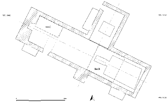
Figure 18: Proposed excavation areas in the church
Summary
The site of Tarbat Old Church features an important medieval building, and is also likely to contain evidence for a Pictish ecclesiastical centre. Since the project includes the development of the church site as a Museum, the opportunity for archaeological investigation should be taken.
The work is designed -
- to elucidate the structural story of the building, and
- to inspect the character of any surviving traces of the Dark Age settlement which preceded it.
Small-scale interventions are planned at the west end, at the east end and in the crypt [Fig. 18]. These excavations are intended to co-exist with the programme of development.
Assessment of the probable impact of refurbishment and development
Refurbishment: The roof is to be repaired and the exterior harling is to be replaced. The internal timber supports, pews and panels are to remain exactly as they are (according to the drawings). Since this work is to occasion no disturbance, it has no archaeological implications.
Development: The following works are likely to have the impact shown:
- Removal of the wooden panelling between the nave and the N aisle. This should allow the exposure of the wall fabric of both nave and N aisle; it can then be observed if they are different and this difference recorded before the walls are covered up again.
- Insertion of services in or on wall fabric behind wooden panels. The fabric concerned would require prior recording.
- Installation of wheelchair toilet at W end. This implies foundations and drains which would need to be archaeologically dug. The assumption is that the provision of a toilet will need (1) a hole 2.5 x 2.5 m and (2) a trench through the burial ground [below].
- Trench(es) through the churchyard. The Centre is expected to be connected to mains water, electricity and sewage. This will require one or more trenches to be dug through the churchyard.
In the authors' view, the development proposals do not represent an abuse of the monument, but are likely to afford added value and added protection. Furthermore such works as do impact on the archaeological assets provide opportunities which are rewarding to research.
Proposed Programme of Archaeological Investigation
Rationale: The work made necessary by development and the work desirable for research purposes are here combined. An understanding of the history of Tarbat Old Church is desirable for two reasons:
- Since there is to be a major study of the defended settlement in which the church stands, and since that settlement is thought to have an early monastic phase signalled by finds in the churchyard, it would be very sensible to take advantage of the opportunity afforded by the development of the church site to examine the use of the site before the church was built.
- Since the church is to become a visitor centre, concerned with presenting the past, it would be prudent to include in that presentation an account of the history of the building itself.
Constraints: Whereas the most comprehensive approach to the inquiry would be the total recording of the wall fabric and the total excavation of the interior, there are several constraints on such an approach.
- On a unique site of this kind, no more should be excavated (and therefore destroyed) than can be understood, for ethical reasons.
- Local support for the project as a whole is thought to depend on an early start to the refurbishment programme. Excavation and recording should not be on such a scale to demand excessive delays.
Research and Management Targets: The realisable research targets, in order of priority, are:
- The structural sequence
- The existence of pre-medieval or pre-church strata
- The use of the crypt, if it is demonstrably medieval or earlier than the present nave walls.
- A sample of medieval burials.
Presently excluded from the research targets, given the constraints detailed above, is a major excavation in the nave. If no earlier strata are contacted, such an excavation would not be justified. If early strata are contacted, a major excavation would be desirable but should be postponed until a context has been provided for it through the settlement excavation programme.
The management constraints associated with the investigation of the church are taken to be:
- The investigation should not delay the refurbishment programme.
- The investigation should be phased with the interior development programme
- Any excavations should as far as possible form part of the exhibit.
Proposed Archaeological Interventions: The targets itemised above can be addressed through the following archaeological works ('interventions'). They are given in order of priority:
Intervention A: Recording of the interior wall fabric, including inside the crypt.
- Aim: To ascertain if the church was medieval in origin.
- Method: The wooden panelling would be totally removed inside the nave and west end. Any wall-plaster encountered should be scrutinised for layering, frescos and other features and recorded. Rotten plaster should then be removed. The wall fabric should be then surveyed and recorded by rectified photography. Any features present in the wall fabric should be examined non-destructively and recorded. Some or all of these features, particularly if evidently medieval, should be left exposed to view if and when the panelling is reinstated. The walling at the west end would be repointed and left exposed, with a light fitted to illuminate the carved stone in the arch of the vault at the W end.
- Timing: During refurbishment, and probably not during the tourist season. The same occasion can be used to check that the walls are structurally sound.
- Time taken: 2-3 weeks
- Public access: none
- Output: Drawn elevations of all accessible wall-fabric, with detail of features.
Intervention B: Excavation of a small area at the E end.
- Aims:
- To establish relationship between crypt and nave
- To establish relationship between nave and N aisle
- To test for existence of pre-church or pre-medieval strata
- To record a sample of medieval and earlier burials
- Method: An area of the wooden floor 6m x 6m will need to be removed [Fig. 18]. The area extends E from a line joining the midpoint of the central porch to the midpoint of the opening to the N aisle. Its E limit is over the crypt. The S limit is the S wall of the nave and the N limit just inside the N aisle. This area will be cleaned, planned and photographed down to the first burial horizon. Graves will be defined and cleaned in order to provide 'free sections' through any intact stratigraphy, which will then be recorded. Further excavation would be undertaken sufficient to (a) expose the relationship between the crypt, the crypt access steps and the nave walls; and (b) expose the relationship between the nave and the N aisle in the E angle of their bond. Spoil would be removed by chute through the opening in the N wall of the nave. Following excavation, the area would be consolidated, except that the access steps would be restored to their original width. It might be suggested that any crucial relationships between the structural elements could also be preserved as part of the display.
- Timing: Before the installation of the design. Provisionally scheduled for July 1996.
- Time taken: 4 weeks
- Public access: A rail could be constructed across the church (N-S), allowing visitors to watch work in progress.
- Output: Full documentation, including a three-dimensional model of the structural sequence, a composite section along grave edges, a N-S section across the church and conserved masonry where it can be exposed to demonstrate the sequence.
Intervention C: An excavation 6m x 2m within the W end. The excavation would be on the N side of the accessible area. It will expose the foundations of the W wall(s) and the N wall.
- Aims:
- To confirm the relationship between the N wall of the nave and the west wall complex.
- To contact strata belonging to pre-church or pre-medieval phases.
- To determine the depth of deposit.
- Method: Advice on stability and the removal of redundant timbers would be taken from an engineer. The paving slabs would be recorded and removed and stacked for reinstatement. The surface would be defined by horizon until grave cuts are visible. These would be defined and excavated as far as possible. The trench would be shored and descend to the subsoil. It is assumed that this trench will contain all the area to be damaged by the installation of the toilet.
- Timing: Could probably be done at the same time as Int.B, ie during the 1996 tourist season.
- Time taken: 4 weeks
- Public access: Public viewing through railing or windows in panelling beside S entrance passage.
- Output: Full documentation, including a section E-W to natural subsoil, two sections N-S to subsoil, showing the foundation trench for the N wall, and a three-dimensional model of the relationship between the walls at foundation level.
Intervention D: The excavation of the service trench .
- Aim: To record the strata to be destroyed by the service trench.
- Method: The trench or trenches would be dug by hand by archaeologists who would record the strata as they went.
- Timing: To be determined by the development plan; preferably at a time of least public attention.
- Time taken: about 1 week for every 10 metres.
- Public access: None
- Output: Section along trench edge; to subsoil if possible.
Intervention E: Watching Brief. Archaeological surveillance would normally be required during refurbishment.
Intervention F: Excavation of the crypt floor. [The recording of the crypt wall fabric would be included in Int.A].
- Aim: To investigate the sequence of use.
- Method: This excavation would ONLY take place if the crypt is found by Int.B to be medieval or earlier. In this case, one half (N) of the strata would be excavated, along an E-W axis.
- Timing: Not before completion of the other works; 1997 at earliest.
- Time taken: 6 weeks
- Public access: Public viewing throughout. Can be phased in as an exhibit after the church has been fully opened to the public.
Summary of archaeological works:
- Int. A: Recording of internal fabric.
Not during tourist season, before or during refurbishment - Int. B-C: Excavations at E end and W end.
During tourist season, before refurbishment begins or after it is finished; before or during installation of display (but not after). - Int. D: Service trench. Not during tourist season, before installation of display.
- Int. E: Watching brief during all development work.
- Analysis and publication of this work.
- Int. F: Excavation of Crypt.
After the other works have been completed, and if justifiable on research grounds.
Timetable:
Mar 96: Acceptance of estimate by Tarbat Historic Trust
Jun 96: Recording of walls (Int. A)
July 96: [in parallel with excavation in fields] Excavations in nave and W end (Int. B-D)
Oct 96: Excavation of service trench (Int. D).
Archaeological Programme 2: Excavation of the Settlement (Sectors 1,2,3)
A T-shaped transect as shown on Fig. 19 meets most of the specifications of the research design. It includes a sizeable part of the easily mappable area next to the fortifications, likely to contain evidence for production and consumption; and it runs north between the churchyard and the spring system, thus connecting the likely ecological and ritual nodes. It extends up to the crest overlooking the beach (Sector 3). If this contains no evidence for maritime exchange, then a further extension on the down-slope towards the present beach may be desirable.
The greater part of this area (i.e. Sector 1) will be susceptible to the 'strip and map' technique which is essentially non-destructive. Normally only surface finds will be recovered. For features chosen for excavation, recovery level of D or E will normally apply (see Appendix 1).
In Sectors 2 and 3, deeper stratification is anticipated, up to 1.2m, of which 80cm is scrambled ploughsoil. At least two phases of excavation will be required in this sector, the first defining the medieval occupation beneath the ploughsoil and the second examining the Early Historic phases. In general the first of these operations will act as a high-level evaluation for the second.
In Sectors 1 and 2, damp or even waterlogged strata are anticipated in the valley bottom. Special equipment may be required, but not on a scale appropriate to deep urban anaerobic deposits.
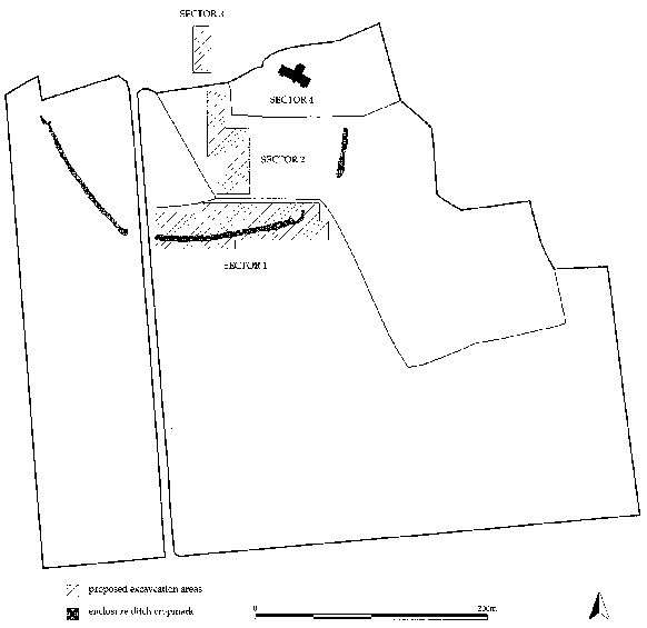
Figure 19: Proposed excavation areas in the enclosure
Programme for the Settlement Excavation [Fig. 19]
1996:
- Sector 2: North
- Sector 3
- Sector 1: West
1997:
- Sector 1: West
- Sector 2: North
1998:
- Sector 1: East
- Sector 2: Centre
1999:
- Sector 1: East
- Sector 2: Centre
2000:
- Sector 2: South
- Sector 4 (church) is investigated in 1996.
2001-3:
- Analysis and publication.
Archaeological Programme 3: Survey of Portmahomack
The zones to be explored are those marked on Fig. 3, and the principal methods to be used are:
- Geophysical survey in Zones D, E, H, J and K.
- Trial excavations (as opportunities permit) in the residential area of Zone J.
- Reviews of documents and local knowledge, particularly of the early 20th century and earlier.
It is hoped that the collection of this information will allow an appreciation of the archaeological potential of the whole of the Portmahomack area, and lead us to any sites where significant intervention is possible.
Resources: It is intended that, apart from incidental expenses to be borne by the rest of the archaeological programme, the bulk of the work will be carried out by students and friends of the project. No specific costings are therefore included.
Archaeological Programme 4: Regional Survey (Dornoch Firth)
In parallel with the Tarbat project, a programme is being initiated which will explore the Dornoch Firth territory in the Early Historic period, and provide the Tarbat site with its context. This will include:
Stage 1: Reconnaissance
- The collection and mapping of all aerial photographs generated by the Moray Aerial Survey (Keillar, Jones and Maude 1993)
- Additional targeted flying
- Mapping Early Historic sites from finds-spots, sculpture and place-names
- Geological mapping to determine the changing configuration of the coastline and inland water.
Stage 2: Evaluation
A list of target areas for evaluation is in preparation. It will probably include:
- Hilton of Cadboll
- Edderton
- Mid Fearn and Wester Fearn
- Golspie
- Dornoch
- Tarradale
- Cyderhall
Stage 3: Strategy
This can be compiled on completion of all or some of the evaluation exercises. The strategy would be expected to include:
A Research Programme, including major and minor excavation projects, study of sculpture and other materials. Many of these projects (like the small-scale evaluations) could be achieved by student contributions at BA/BSc, MA/MSc and DPhil level.
A Management Programme, including recommended protection for sites, recommended surveys for management purposes and presentation/education proposals.
The initial proposal is to carry out stages 1 to 3 of the survey in parallel with the investigation at the Tarbat site.
Timetable and Costings
1996:
- Preliminary discussions with Highland Region
1996-8:
- Aerial reconnaissance sorties (possibly B. Jones, Manchester)
- Student evaluation projects (supported by University of York)
1997:
- Professional evaluation of Hilton of Cadboll, Mid Fearn and other sites
1998:
- Strategy compiled and research proposals submitted for funding
NEXT: Archaeological Contributions
BACK: Project Design
Last updated 10 October, 2003.
Contact the Tarbat Discovery Programme


© 2003-2006 University of York
![]()
![]()
![]()