Mapping the World, 1100-1300
Overview
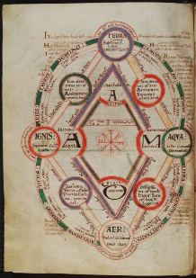
This module focuses on the way in which the medieval world is represented in visual form through maps and diagrams: images which have to this day remained crucial to the organisation, communication and transmission of knowledge. Through the analysis of key examples we will assess how the cosmos was imagined in its overall structure and its individual components (including phenomena such as the movement of the planets, and the relationship between the four elements), and how the known world was visualised in its geographical and historical dimensions. The twelfth and thirteenth centuries witnessed important developments in the way in which this type of knowledge was laid out and visualised, and we will thus begin in the early twelfth century with images in Lambert of Saint-Omer's important encyclopaedia Liber Floridus, and end around 1300 with the famous Hereford and Ebstorf world maps.
Aims
By the end of the module, students should have acquired:
- a good knowledge of key examples of medieval maps and diagrams of the period
- acquaintance with their intellectual and cultural contexts
- an understanding of the debates about and approaches to the subject
Preliminary reading
- Evelyn Edson, Mapping time and space: how medieval mapmakers viewed their world (London, 1997)
- Evelyn Edson and Emilie Savage-Smith, Medieval Views of the Cosmos: Picturing the Universe in the Christian and Islamic Middle Ages (Oxford, 2004)
- Michael Evans, 'The Geometry of the Mind', in Architectural Association Quarterly 12/4 (1980), pp. 32-55
- P. D. A. Harvey (ed.), The Hereford World Map: Medieval World Maps and their Context (London, 2006)
- Pippa Salonius and Andrea Worm (eds), The Tree: Symbol, Allegory, and Mnemonic Device in Medieval Art and Thought (Turnhout, 2014), pp. 1-12
- John E. Murdoch, Album of Science: Antiquity and the Middle Ages (New York, 1984)
- James Elkins, The Domain of Images (New York, 1999), pp. 3-12
Module information
- Module title
Mapping the World, 1100-1300- Module number
HOA00075M- Convenor
Hanna Vorholt
For postgraduates